 view gallery view gallery SW2.9 km SW2.9 km
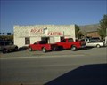
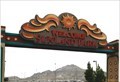
|   Rosa's Cantina - El Paso Rosa's Cantina - El Paso
in Immortalized in Lyrics Immortalized in the Marty Robbins' song "El Paso", this cantina is hidden in an out-of-the-way location so hopefully this will help others find it. posted by:  rilekyle rilekyle location: Texas date approved: 10/20/2006 last visited: 02/17/2018 |
 view gallery view gallery W3.4 km W3.4 km
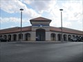
|  El Paso TX Post Office - Coronado Station - 79912 El Paso TX Post Office - Coronado Station - 79912
in U.S. Post Offices This post office is located a block off SR 20 at 7383 Remcon Circle in El Paso TX. posted by: VQ9JC location: Texas date approved: 08/25/2013 last visited: never |
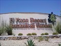 view gallery view galleryW3.5 km |  El Paso Desert Botanical Garden El Paso Desert Botanical Garden
in Botanical Gardens The Botanical Garden at Keystone is a project adopted by the Junior League of El Paso in the year 2000. In 2003, the Rotary Club of El Paso committed to building Phase Two of the garden. posted by: jackrock location: Texas date approved: 01/19/2010 last visited: never |
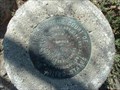 view gallery view gallerySW3.5 km |  BORDER MONUMENT 97 BORDER MONUMENT 97
in Border Crossings Border Monument 97 of Texas and New Mexico, TX-NM posted by:  GEO*Trailblazer 1 GEO*Trailblazer 1 location: Texas date approved: 11/28/2007 last visited: 11/28/2007 |
 view gallery view gallerySW3.9 km |  Sunland Park Racetrack & Casino - Sunland Park NM Sunland Park Racetrack & Casino - Sunland Park NM
in Casinos Sunland Park Racetrack & Casino is located at 1200 Futurity Drive, Sunland Park NM 88063. I was there on May 15, 2005. posted by: Don.Morfe location: New Mexico date approved: 01/20/2024 last visited: 01/20/2024 |
 view gallery view gallerySW3.9 km |  Sunland Park Racetrack & Casino - Sunland Park NM Sunland Park Racetrack & Casino - Sunland Park NM
in Wikipedia Entries Sunland Park Racetrack & Casino is located at 1200 Futurity Drive, Sunland Park NM 88063. I was there on May 15, 2005. posted by: Don.Morfe location: New Mexico date approved: 01/20/2024 last visited: 01/20/2024 |
 view gallery view gallery S4.5 km S4.5 km
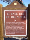
|  El Paso Del Rio Del Norte El Paso Del Rio Del Norte
in New Mexico Historical Markers Marker is near Sunland Park, New Mexico, in Dona Ana County. Marker is on McNutt Road 2.2 miles south of Racetrack Drive, on the left when traveling south. posted by: leadhiker location: New Mexico date approved: 06/18/2011 last visited: 12/29/2014 |
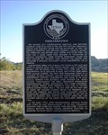
 view gallery view galleryS4.7 km |  The Pass of the North The Pass of the North
in Texas Historical Markers Roadside historical marker describing the northernmost Rocky Mountains pass that stays snow-free throughout the year. posted by: rilekyle location: Texas date approved: 10/21/2006 last visited: 12/29/2014 |
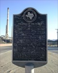
 view gallery view galleryS4.7 km | Smeltertown in Texas Historical Markers Historical marker describing the history of the smelting and refining operations in the area and the town that grew up around it. There is also a Spanish version of the historical marker here. posted by: rilekyle location: Texas date approved: 10/21/2006 last visited: 12/29/2014 |
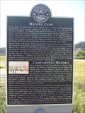 view gallery view galleryS4.7 km |  Madero Camp Madero Camp
in Signs of History Marker is about 500 feet southwest of the intersection of Executive Center Blvd. and West Paisano Dr. (US-85). posted by: leadhiker location: Texas date approved: 06/20/2011 last visited: 12/29/2014 |
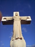 view gallery view galleryS4.8 km |  Mount Cristo Rey Mount Cristo Rey
in Christian Crosses Christ on the Cross atop a small peak near Sunland Park, New Mexico. posted by: dogue location: New Mexico date approved: 09/12/2008 last visited: 07/19/2008 |
 view gallery view gallery SE4.8 km SE4.8 km
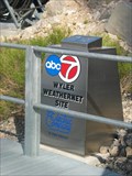
|  Wyler Weathernet Site Wyler Weathernet Site
in Weather Stations Local television automated weather station located at Ranger Peak in the Franklin Mountains of El Paso, TX. posted by: rilekyle location: Texas date approved: 07/04/2007 last visited: 02/15/2010 |
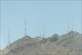 view gallery view gallerySE4.8 km |  Franklin Mountains Antenna farm -- El Paso TX USA Franklin Mountains Antenna farm -- El Paso TX USA
in Radio and Television Transmitter Towers The antenna farm for the El Paso/Las Cruces TV market is located on Comanche and Ranger Peaks in the Franklin Mountains, the highest point between the two cities that are on either side of the range. posted by: Benchmark Blasterz location: Texas date approved: 04/12/2017 last visited: 08/01/2018 |
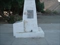
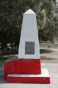 view gallery view galleryS5 km |  CE0655 BOUNDARY MON 1 MX US -- El Paso TX CE0655 BOUNDARY MON 1 MX US -- El Paso TX
in U.S. Benchmarks Border Monument No. 1 was set in 1855 and designated an official US Coast and Geodetic Survey benchmark in 1893. posted by: Benchmark Blasterz location: Texas date approved: 02/24/2017 last visited: 08/10/2010 |
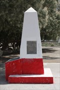 view gallery view galleryS5 km |  US/Mexico Boundary Marker 1 - Juarez, Chihuahua, MX US/Mexico Boundary Marker 1 - Juarez, Chihuahua, MX
in Latin American Benchmarks An International Boundary and Water Commission border monument that as of 2010 is INSIDE MEXICO -- see the long description for important information posted by: Benchmark Blasterz location: Chihuahua, Mexico date approved: 02/22/2017 last visited: 08/10/2010 |
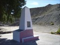 view gallery view galleryS5 km |  International Boundary Marker #1 International Boundary Marker #1
in U.S. Historic Survey Stones and Monuments This monument was placed on January 31, 1855 in accordance with the 1853 treaty. posted by: leadhiker location: New Mexico date approved: 06/18/2011 last visited: 12/29/2014 |
 view gallery view galleryS5 km | BOUNDARY MON 1 MX US in Border Crossings Boundary Monument 1 MX-US The Gadsen Purchase TX_MX
Waymarkers please note that this monument DOES NOT mark the current US border with Mexico posted by: GEO*Trailblazer 1 location: Texas date approved: 11/28/2007 last visited: 12/29/2014 |
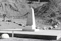 view gallery view galleryS5 km |  International Boundary Marker No. 1, El Paso, TX International Boundary Marker No. 1, El Paso, TX
in Engineering Landmarks Bordering Texas, New Mexico, and Mexico, this International Boundary Marker not only represents an international boundary but is also a monument to the professional skills of the American & Mexican surveyors who were called upon to locate it in 1855. posted by: Tygress location: Texas date approved: 05/07/2014 last visited: 08/10/2010 |
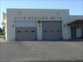 view gallery view galleryW5 km |  Fire Station No. 15 Fire Station No. 15
in Firehouses Located near the industrial portion of El Paso, this firehouse is adjacent to a city park and residential neighborhood. posted by: rilekyle location: Texas date approved: 10/22/2006 last visited: 10/21/2006 |
 view gallery view gallerySE5.1 km |  Wyler Aerial Tramway - Franklin Mountains State Park - El Paso, TX Wyler Aerial Tramway - Franklin Mountains State Park - El Paso, TX
in State/Provincial Parks Aerial tramway that takes visitors up to one of the southern peaks of the Franklin Mountains in El Paso, TX. posted by: rilekyle location: Texas date approved: 07/07/2007 last visited: 09/02/2017 |
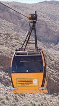 view gallery view gallerySE5.1 km |  Wyler Aerial Tramway - El Paso, TX Wyler Aerial Tramway - El Paso, TX
in Aerial Lifts This tramway is located in the Franklin Mountains overlooking West panning all the way to East El Paso. From the top you can see the Rio Grande River separating the US and Mexico. Keep in mind the Tramway is only opened Fri, Sat, and Sunday. posted by: vanaya2002 location: Texas date approved: 04/21/2013 last visited: 09/02/2017 |
 view gallery view gallerySE5.1 km |  Wyler Aerial Tramway Wyler Aerial Tramway
in Penny Smashers The Wyler Aerial Tramway features an aerial cable car situated on rugged mountain and rock formations posted by: schnookies location: Texas date approved: 03/01/2006 last visited: 03/16/2013 |
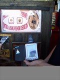
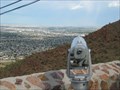 view gallery view gallerySE5.1 km |  Wyler Aerial Tramway - El Paso, TX - Lower Monocular Wyler Aerial Tramway - El Paso, TX - Lower Monocular
in Coin-Op Binoculars This monocular is located at the base of the Wyler Aerial Tramway in El Paso, TX. posted by: rilekyle location: Texas date approved: 07/05/2007 last visited: 03/16/2013 |
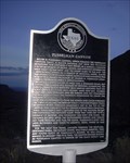 view gallery view gallery NE6.4 km NE6.4 km
| Fusselman Canyon in Texas Historical Markers The Fusselman Canyon marker is located in a roadside park area of the Franklin Mountains State Park off of Transmountain Drive. posted by: rilekyle location: Texas date approved: 08/13/2006 last visited: 01/29/2013 |
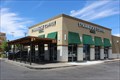 view gallery view gallerySE6.4 km |  Starbucks - Mesa & Kerbey - El Paso, TX Starbucks - Mesa & Kerbey - El Paso, TX
in Starbucks Stores Starbucks at 2300 N Mesa St, El Paso, TX. Phone is 915-577-0305. posted by: QuarrellaDeVil location: Texas date approved: 09/20/2017 last visited: 03/23/2018 |
|