 view gallery view gallery NW6.8 km NW6.8 km
|   Harris Neck Wildlife Refuge - Townsend, GA Harris Neck Wildlife Refuge - Townsend, GA
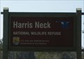
in National Wildlife Refuges Harris Neck NWR was established in 1962 by transfer of federal lands formerly managed by the Federal Aviation Administration as a WWII Army airfield. The refuge's 2,824 acres consist of saltwater marsh, grassland, mixed deciduous woods and cropland. posted by:  onfire4jesus onfire4jesus location: Georgia date approved: 04/07/2008 last visited: 05/26/2019 |
 view gallery view gallery N6.9 km N6.9 km
|  Thomas Landing - Harris Neck WIldlife Refuge Thomas Landing - Harris Neck WIldlife Refuge
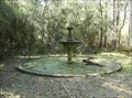
in Remains of Settlements This fountain and two decorative pools are all that remain of the 19th century plantation that existed here in the Harris Neck National Wildlife Refuge. posted by: onfire4jesus location: Georgia date approved: 01/11/2013 last visited: 05/26/2019 |
 view gallery view galleryN6.9 km |  Thomas Landing Fountain Thomas Landing Fountain
in Converted Fountains This fountain and two decorative pools are all that remain of the 19th century plantation that existed here in the Harris Neck National Wildlife Refuge. posted by: onfire4jesus location: Georgia date approved: 04/06/2008 last visited: 05/26/2019 |
 view gallery view galleryNW7.1 km |  Harris Neck National Wildlife Refuge - Townsend, GA Harris Neck National Wildlife Refuge - Townsend, GA
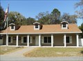
in National Public Lands Passport Locations Harris Neck National Wildlife Refuge is located in SE Georgia. This visitor's center has a cancellation stamp for Harris Neck as well as Blackbeard Island which can only be reached by boat. posted by: onfire4jesus location: Georgia date approved: 03/08/2013 last visited: 05/26/2019 |
 view gallery view galleryNW7.1 km |  Harris Neck National Wildlife Refuge - Townsend, GA Harris Neck National Wildlife Refuge - Townsend, GA
in Ranger Stations Harris Neck National Wildlife Refuge is located in SE Georgia. This Ranger's Station has literature about the refuge and the nearby Blackbeard Island, a small nature display and a small gift shop. posted by: onfire4jesus location: Georgia date approved: 05/07/2008 last visited: 05/26/2019 |
 view gallery view galleryNW7.7 km |  Harris Neck Army Airfield - Townsend, GA Harris Neck Army Airfield - Townsend, GA
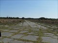
in World War II Sites At the start of World War II, the Army took over the existing airfield at Harris Neck for training pilots. After WWII, the Army gave the land to McIntosh County. Today it is part of the Harris Neck Wildlife Refuge. posted by: onfire4jesus location: Georgia date approved: 07/23/2008 last visited: 05/26/2019 |
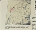 view gallery view galleryNW7.7 km |  Harris Neck Army Airfield - Townsend, GA Harris Neck Army Airfield - Townsend, GA
in 'You Are Here' Maps The Harris Neck Army Airfield was a World War II facility. All that remains now are the old runways. It is now part of the Harris Neck Wildlife Refuge. This 'You Are Here' map shows visitors where they are on the runways. posted by: onfire4jesus location: Georgia date approved: 04/12/2008 last visited: 05/26/2019 |
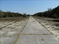 view gallery view galleryNW7.7 km |  Harris Neck Army Airfield - Townsend, GA Harris Neck Army Airfield - Townsend, GA
in Military Installations At the start of World War II, the Army took over the existing airfield at Harris Neck for training pilots. After WWII, the Army gave the land to McIntosh County. Today it is part of the Harris Neck Wildlife Refuge. posted by: onfire4jesus location: Georgia date approved: 04/13/2008 last visited: 05/26/2019 |
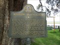
 view gallery view gallery W8.9 km W8.9 km
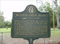
|  Sutherland’s Bluff Historical Marker Sutherland’s Bluff Historical Marker
in Georgia Historical Markers Sutherland’s Bluff Historical Marker on Sutherland Rd in Shellman Bluff, GA posted by: onfire4jesus location: Georgia date approved: 06/27/2007 last visited: 09/01/2001 |
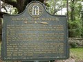
 view gallery view gallery SW13.4 km SW13.4 km
| Old Belleville or Troup Cemetery Historical Marker in Georgia Historical Markers Old Belleville or Troup Cemetery Historical Marker in Crescent, Ga, 0.5 mile left of road from Ga Hwy 99 to Pelican Point posted by: onfire4jesus location: Georgia date approved: 06/27/2007 last visited: 09/01/2001 |
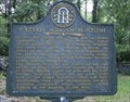
 view gallery view galleryW13.8 km | Mallow Plantation Historical Marker in Georgia Historical Markers Mallow Plantation Historical Marker at the end of Pine Harbor Rd in Pine Harbor, GA posted by: onfire4jesus location: Georgia date approved: 06/27/2007 last visited: 09/01/2001 |
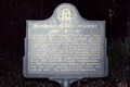
 view gallery view galleryW14 km | Colonel John McIntosh Historical Marker in Georgia Historical Markers Colonel John McIntosh Historical Marker in Cemetery on Fairhope Rd in Pine Harbor, GA posted by: onfire4jesus location: Georgia date approved: 06/27/2007 last visited: 09/01/2001 |
 view gallery view galleryW14 km | Captain William McIntosh Historical Marker in Georgia Historical Markers Captain William McIntosh Historical Marker in cemetery on Fairhope Rd in Pine Harbor, GA posted by: onfire4jesus location: Georgia date approved: 06/27/2007 last visited: 09/01/2001 |
 view gallery view gallerySW15 km | Baisden's Bluff Academy GHM 095-12 in Georgia Historical Markers Located on GA 99 at Donelly Rd in the community of Crescent. posted by:  Markerman62 Markerman62 location: Georgia date approved: 10/30/2015 last visited: 11/08/2015 |
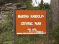 view gallery view galleryN15.1 km |  Martha Randolph Stephens Park - Halfmoon Landing, GA Martha Randolph Stephens Park - Halfmoon Landing, GA
in Municipal Parks and Plazas This small park is located in eastern Liberty County in Georgia. It is located on Colonel Island Rd in Halfmoon Landing, GA. posted by: onfire4jesus location: Georgia date approved: 03/23/2008 last visited: 03/14/2008 |
 view gallery view galleryW16.3 km |  McIntosh Family Cemetery - South Newport, GA McIntosh Family Cemetery - South Newport, GA
in Worldwide Cemeteries The McIntosh Family Cemetery is located on U.S. 17, 1.7 miles south of the South Newport River in South Newport, Georgia, USA. There are approximately 50 graves in this cemetery. posted by: Marine Biologist location: Georgia date approved: 06/30/2008 last visited: 05/15/2010 |
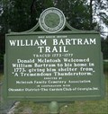 view gallery view galleryW16.3 km |  William Bartram Trail - South Newport, GA William Bartram Trail - South Newport, GA
in Bartram Trail Historical Markers William Bartram Trail Historical Marker on US 17/Ga 25 1.7 miles South of the South Newport River in South Newport, GA posted by: onfire4jesus location: Georgia date approved: 09/12/2007 last visited: 12/27/2018 |
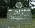 view gallery view galleryW16.3 km | William Bartram Trail Historical Marker in Georgia Historical Markers William Bartram Trail Historical Marker on US 17/Ga 25 1.7 miles South of the South Newport River in South Newport, GA posted by: onfire4jesus location: Georgia date approved: 06/27/2007 last visited: 12/27/2018 |
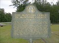 view gallery view galleryW16.3 km | The McIntosh Family of McIntosh County Historical Marker in Georgia Historical Markers The McIntosh Family of McIntosh County Historical Marker on US 17/Ga 25 1.7 miles South of the South Newport River in South Newport, GA posted by: onfire4jesus location: Georgia date approved: 06/27/2007 last visited: 09/01/2001 |
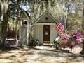 view gallery view galleryW16.4 km |  Christ's Chapel in Memory Park - South Newport, GA Christ's Chapel in Memory Park - South Newport, GA
in Waychapels Christ's Chapel in Memory Park is located on the north edge of South Newport. It was built in 1949 by Mrs. Agnes Harper. It is billed as "The Smallest Church in America". posted by: onfire4jesus location: Georgia date approved: 04/11/2008 last visited: 05/26/2019 |
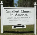 view gallery view galleryW16.4 km |  "Smallest Church in America" - South Newport, GA "Smallest Church in America" - South Newport, GA
in Roadside Attractions The Smallest Church in America was built in 1949 by Mrs. Agnes Harper and is "deeded to Jesus Christ." It is located on US 17 north of South Newport. posted by: onfire4jesus location: Georgia date approved: 04/11/2008 last visited: 05/26/2019 |
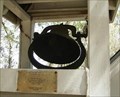 view gallery view galleryW16.4 km |  Praise Bell at the Smallest Church in America - South Newport, GA Praise Bell at the Smallest Church in America - South Newport, GA
in Bells This Bell was an offering to the Smallest Church in America by Wayne and Toni Moeller on Jan. 1, 1998. It is located on US 17 on the north edge of South Newport, GA. posted by: onfire4jesus location: Georgia date approved: 04/12/2008 last visited: 04/06/2011 |
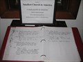 view gallery view galleryW16.4 km |  'Smallest Church in America' Guest Book - South Newport, GA 'Smallest Church in America' Guest Book - South Newport, GA
in Guest Books Located inside Christ's Chapel in Memory Park, visitors are encouraged to log their visit and donate if the need is felt. posted by: ChapterhouseInc location: Georgia date approved: 09/20/2010 last visited: 07/16/2014 |
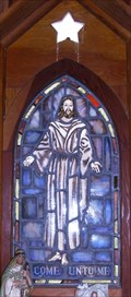 view gallery view galleryW16.4 km |  "Come unto me" - Smallest Church in America - South Newport, GA "Come unto me" - Smallest Church in America - South Newport, GA
in Stained Glass Windows This stained glass window adorns the Smallest Church in America in South Newport, GA. It shows Jesus and the words "Come unto me". posted by: onfire4jesus location: Georgia date approved: 04/11/2008 last visited: 07/16/2014 |
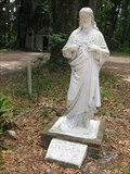 view gallery view galleryW16.4 km |  Jesus - South Newport, GA Jesus - South Newport, GA
in Statues of Religious Figures Located in front of the 'Smallest Church in America'. The statue dedicates the location to Christ. posted by: ChapterhouseInc location: Georgia date approved: 09/21/2010 last visited: 07/16/2014 |
|