 view gallery view gallery NE1 km NE1 km
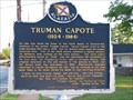
|   Truman Capote Truman Capote
in Alabama Historical Markers Monroeville home of Truman Capote. posted by:  Thorny1 Thorny1 location: Alabama date approved: 07/11/2008 last visited: 07/11/2010 |
 view gallery view gallery N1.3 km N1.3 km
|  Old Monroe County Courthouse - To Kill A Mockingbird Old Monroe County Courthouse - To Kill A Mockingbird
in Literary Sites Old Monroeville County Courthouse - the setting for the famous courtroom scene in "To Kill A Mockingbird" by Harper Lee. posted by: Thorny1 location: Alabama date approved: 07/22/2008 last visited: 07/11/2010 |
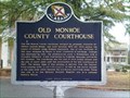 view gallery view galleryN1.3 km | Old Monroe County Courthouse - Monroeville, AL in Alabama Historical Markers Historical Marker commemorating the Old Monroe County Courthouse, made famous from the novel and movie, "To Kill A Mockingbird, posted by:  Six Little Spookies Six Little Spookies location: Alabama date approved: 02/02/2008 last visited: 04/12/2014 |
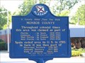 view gallery view galleryN1.3 km | A County Older Then The State - Monroe County in Alabama Historical Markers Monroe County, Alabama is older then the state itself - created in 1815, Alabama did not become a state until 1819. posted by: Thorny1 location: Alabama date approved: 07/11/2008 last visited: 07/31/2011 |
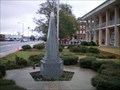 view gallery view galleryN1.3 km |  Monroeville, AL Eternal Flame Monroeville, AL Eternal Flame
in Eternal Flames Eternal Flame outside the Monroeville, Alabama, Courthouse. posted by: Six Little Spookies location: Alabama date approved: 01/27/2008 last visited: 01/21/2008 |
 view gallery view gallery S5.3 km S5.3 km
|  Lambert's - Foley, Alabama Lambert's - Foley, Alabama
in Independent Diners Lambert's - Home of the Thrown Rolls, Lambert's Foley, Alabama, location. posted by: gwtriker location: Alabama date approved: 06/03/2010 last visited: 03/06/2015 |
 view gallery view gallery W7.1 km W7.1 km
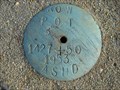
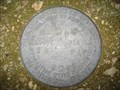
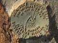
|  1427 + 50 1427 + 50
in U.S. Benchmarks Alabama State Highway Dept. ROW marker on AL 47 near Mexia, Alabama posted by: jkselby location: Alabama date approved: 12/15/2007 last visited: never |
 view gallery view gallery SW10.1 km SW10.1 km
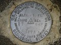
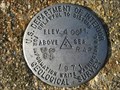
| US Geological Survey elevation marker 413 FT 27 RAP 1971 in U.S. Benchmarks USGS vertical control mark 1 mile NE of Frisco City, AL posted by: jkselby location: Alabama date approved: 12/21/2007 last visited: never |
 view gallery view gallery SE11.7 km SE11.7 km
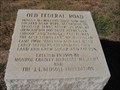
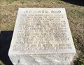
| Old Federal Road - Repton, Alabama in Alabama Historical Markers Marker indicating the location of a stage stop on Old Federal Road. It is located north of Repton, Alabama. posted by: xptwo location: Alabama date approved: 11/30/2011 last visited: 03/07/2015 |
 view gallery view gallery E13.2 km E13.2 km
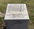
| Old Federal Road - Bermuda, AL in Alabama Historical Markers One of eight stone markers along the Alabama portion of the Federal road established as a postal route by President Jefferson. Located at the intersection of County Road 5 and County Road 20. posted by: hoteltwo location: Alabama date approved: 03/24/2015 last visited: never |
 view gallery view gallerySW14.5 km | US Geological Survey elevation marker 404 FT 86 RAP 1971 in U.S. Benchmarks USGS elevation mark 2 miles SW of Frisco City, Alabama posted by: jkselby location: Alabama date approved: 12/21/2007 last visited: never |
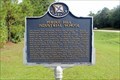
 view gallery view gallerySE14.6 km | Historic and Beautiful Repton - Repton, AL in Alabama Historical Markers Located on Alabama Highway 41 near McMillan Street, the marker describes the history of Repton, the beginning of railroads in the area and the withering economy and population of the town and its desire to grow again. posted by: hoteltwo location: Alabama date approved: 01/17/2017 last visited: 08/27/2019 |
 view gallery view galleryW15.9 km |  Perdue Hill, AL 36470 Perdue Hill, AL 36470
in U.S. Post Offices Located inside a gas station store this rural post office serves about 300 mailboxes in the area. posted by: hoteltwo location: Alabama date approved: 12/06/2013 last visited: never |
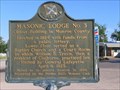 view gallery view galleryW16.1 km | Masonic Lodge #3 in Alabama Historical Markers Built in 1824 - oldest building in Monroe County. posted by: Thorny1 location: Alabama date approved: 07/11/2008 last visited: 08/27/2019 |
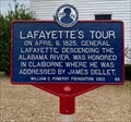 view gallery view galleryW16.1 km | Lafayette's Tour - Perdue Hill, AL in Alabama Historical Markers From July 1824 to September 1825, the Marquis de Lafayette, the last surviving French general of the American Revolutionary War, made a tour of the 24 states in the United States. posted by: hoteltwo location: Alabama date approved: 03/12/2024 last visited: never |
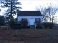 view gallery view galleryW16.1 km |  William Barret Travis Home - Perdue Hill, AL William Barret Travis Home - Perdue Hill, AL
in Relocated Structures Relocated home of the Texas hero and commander of the Alamo, William Travis. posted by: hoteltwo location: Alabama date approved: 12/10/2013 last visited: never |
 view gallery view gallerySW16.3 km | Ala. State Hwy. Dept. UE 13 1962 in U.S. Benchmarks An Ala. State Highway Dept. survey mark located on AL 21, north of Megargel, Alabama. posted by: jkselby location: Alabama date approved: 12/05/2007 last visited: never |
 view gallery view gallerySW16.3 km | USGS survey mark 1971, near Megargel, AL in U.S. Benchmarks A USGS vertical control mark, third order or better with tablet. posted by: jkselby location: Alabama date approved: 12/05/2007 last visited: never |
 view gallery view galleryE16.4 km | Old Federal Road - Burnt Corn, AL in Alabama Historical Markers One of eight stone markers along the Alabama portion of the Federal road established as a postal route by President Jefferson. Located at the intersection of County Road 5 and County Road 15. posted by: hoteltwo location: Alabama date approved: 03/24/2015 last visited: never |
 view gallery view galleryW16.6 km | Perdue Hill Industrial School in Alabama Historical Markers Located on US 84 just west of Dales Ferry Road in Perdue Hill. posted by: Markerman62 location: Alabama date approved: 09/09/2019 last visited: 08/27/2019 |
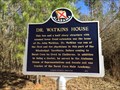 view gallery view galleryE17.4 km | Dr. Watkins House - Burnt Corn, AL in Alabama Historical Markers Located on Conecuh County Rd 5, about a mile north of CR-15, notes the house and life of a prominent doctor and politician, John Watkins. posted by: hoteltwo location: Alabama date approved: 03/22/2015 last visited: never |
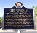 view gallery view galleryE17.7 km | First School in Conecuh County - Burnt Corn, AL in Alabama Historical Markers Located on Conecuh County Road 15, east of County Road 5 this marker notes the former location of the first school in this rural county. posted by: hoteltwo location: Alabama date approved: 03/22/2015 last visited: never |
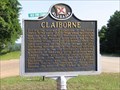 view gallery view galleryW17.9 km | Claiborne in Alabama Historical Markers Claiborne, AL also entertained LaFayette on his travels in 1825. posted by: Thorny1 location: Alabama date approved: 07/11/2008 last visited: 05/10/2024 |
 view gallery view galleryW17.9 km | Piache in Alabama Historical Markers Located on US 84 at Old Fort Claiborne Road posted by: Markerman62 location: Alabama date approved: 09/09/2019 last visited: 08/27/2019 |
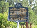 view gallery view galleryW17.9 km | Fort Claiborne - Monroe County, AL in Alabama Historical Markers Located in Monroe County, AL and built to support the settlers and defend against Creek Indian attacks. posted by: Thorny1 location: Alabama date approved: 07/11/2008 last visited: 08/27/2019 |
|