  W9.3 km W9.3 km
|   Camp Livingston Hickman Loop Multi-Use Trail Camp Livingston Hickman Loop Multi-Use Trail
in Mountain Bike Trailheads The Hickman Trail Loop is a moderately difficult trail that traverses through varying trail types but is predominately upland pine hills. Hiking/Bike/Horse/ATV posted by:  satmaster satmaster location: Louisiana date approved: 04/08/2006 last visited: 04/11/2008 |
 view gallery view gallery NW10 km NW10 km
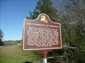
|  The Community of Fishville The Community of Fishville
in Louisiana Historical Markers Located at 2727 Highway 8, Pollock, LA posted by: kwashnak location: Louisiana date approved: 04/18/2012 last visited: never |
 SW11.1 km SW11.1 km
| Camp Livingston Clear Creek Loop Multi-Use Trail in Mountain Bike Trailheads The Clear Creek Loop Trail is an easy to moderate OHV trail that traverses across a wide variety of terrain. A number of creek crossings surrounded by a hardwood bottomland setting, to very dense hilly pine stretches will keep the rider alert and interested in what to expect next. Hiking/Bike/Horse/ATV posted by: satmaster location: Louisiana date approved: 04/08/2006 last visited: 04/11/2008 |
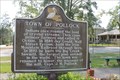 view gallery view galleryNW14 km | Town of Pollock in Louisiana Historical Markers Marker in the center of town celebrating town's history. Located in small park on Thornberg Street (LA 8) west of 165 near Stewart Street. posted by: kwashnak location: Louisiana date approved: 11/11/2013 last visited: never |
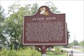 view gallery view galleryNW14.2 km | Oction House in Louisiana Historical Markers Marker near the center of town. Located on Thornberg Street (LA 8) west of 165 near Harvey Street. posted by: kwashnak location: Louisiana date approved: 11/11/2013 last visited: never |
 view gallery view galleryW14.3 km | Pollock School - Pollock, LA in Louisiana Historical Markers Marker gives history about this school in small central Louisiana town. posted by: scrambler390 location: Louisiana date approved: 08/30/2019 last visited: never |
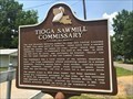 view gallery view gallerySW18 km | Tioga Sawmill Commissary - Tioga, LA in Louisiana Historical Markers Marker gives account of long gone swamill commissary that closed in 1981. posted by: scrambler390 location: Louisiana date approved: 08/29/2019 last visited: never |
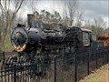 view gallery view gallerySW18 km |  Illinois Central #333 - Tioga, LA Illinois Central #333 - Tioga, LA
in Locomotives 1918 ALCO/Cooke 0-6-0 steam locomotive that performed switching duties for the Illinois Central RR for over 40 years. posted by:  hykesj hykesj location: Louisiana date approved: 02/14/2023 last visited: never |
 view gallery view gallerySW20.3 km |  Kisatchie National Forest Headquarters Smokey Bear - Pineville, LA Kisatchie National Forest Headquarters Smokey Bear - Pineville, LA
in Smokey Bear Sign Sightings Large Smokey, stands proud in front of the National Forest Headquarters. posted by: scrambler390 location: Louisiana date approved: 08/25/2019 last visited: never |
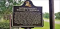 view gallery view gallerySW20.3 km | Superintendent William T. Sherman - Pineville, LA in Louisiana Historical Markers 2 sided marker gives account of when Sherman was Superintendent of Louisiana Seminary of Learning. posted by: scrambler390 location: Louisiana date approved: 08/30/2019 last visited: never |
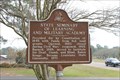 view gallery view gallerySW20.3 km | State Seminary of Learning and Military Academy in Louisiana Historical Markers Former site of the Louisiana State Seminary of Learning and Military Academy (later LSU). Park where the original buildings stood. Located at 2500 Shreveport Highway (US 71) in Pineville. posted by: kwashnak location: Louisiana date approved: 04/14/2013 last visited: never |
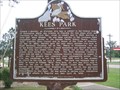 view gallery view gallerySW20.8 km | Kees Park in Louisiana Historical Markers On Hwy 28 East out straight off Hwy 167 north out of Alexandria and right into the parking lot where the park is located. posted by: briefnotion location: Louisiana date approved: 05/31/2008 last visited: 10/15/2011 |
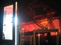 view gallery view gallerySW20.8 km |  The Oasis The Oasis
in Wi-Fi Hotspots Wi-Fi Hotspot for Paying Customers. Talk to the cashier with log on instructions. posted by: briefnotion location: Louisiana date approved: 05/27/2008 last visited: never |
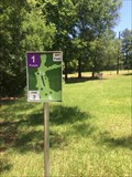 view gallery view gallerySW21.9 km |  Fort Buhlow Disc Golf Course (Purple) - Pineville, LA Fort Buhlow Disc Golf Course (Purple) - Pineville, LA
in Disc Golf Courses One of two 18-hole Disc Golf Courses at Buhlow Recreation Area in Pineville, Louisiana. This is the Purple woodland course. posted by: bonsaai location: Louisiana date approved: 05/16/2014 last visited: never |
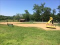 view gallery view gallerySW22 km |  Buhlow Recreation Area Playground - Pineville, LA Buhlow Recreation Area Playground - Pineville, LA
in Public Playgrounds Small playground area at Buhlow Recreation Area in Pineville, Louisiana. Open sunrise to sunset, no entrance fee. posted by: bonsaai location: Louisiana date approved: 05/16/2014 last visited: never |
 view gallery view gallerySW22 km | Cavanaugh Hall of Science - Pineville, LA in Louisiana Historical Markers Marker give history on the naming of this hall on the campus of Louisiana College. posted by: scrambler390 location: Louisiana date approved: 08/30/2019 last visited: never |
 view gallery view gallerySW22.2 km | Louisiana College in Louisiana Historical Markers On Campus in front of Alexandria Hall. posted by: kwashnak location: Louisiana date approved: 04/14/2013 last visited: never |
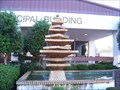 view gallery view gallerySW22.5 km |  Pineville Municipal Building Fountain Pineville Municipal Building Fountain
in Fountains Stone Fountain posted by: Sequoia_2 location: Louisiana date approved: 11/11/2007 last visited: 07/19/2011 |
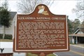 view gallery view gallerySW22.9 km | Alexandria National Cemetery in Louisiana Historical Markers Alexandria National Cemetery entrance, East Shamrock Street in Pineville, one block off of Main. posted by: kwashnak location: Louisiana date approved: 04/14/2013 last visited: never |
 view gallery view gallerySW22.9 km | City of Pineville in Louisiana Historical Markers City of Pineville marker, 731 Main Street (Main Street & East Shamrock Street) in front of Pineville Old Town Hall Museum. posted by: kwashnak location: Louisiana date approved: 04/14/2013 last visited: 04/25/2013 |
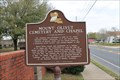 view gallery view gallerySW22.9 km | Mount Olivet Cemetery and Chapel in Louisiana Historical Markers Cemetery - 335 Main Street, Pineville posted by: kwashnak location: Louisiana date approved: 04/14/2013 last visited: never |
 view gallery view gallerySW23 km |  Red River Boat Launch Red River Boat Launch
in Boat Ramps Paved boat ramp with plenty of facilities nearby. There is no charge to access the rivers launch but the park is locked at night. posted by: briefnotion location: Louisiana date approved: 05/27/2008 last visited: never |
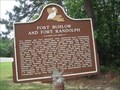 view gallery view gallerySW23.5 km | Fort Buhlow and Fort Randolph in Louisiana Historical Markers Located on Highway 71 North, on the left, just after crossing the Red River Bridge. posted by: briefnotion location: Louisiana date approved: 05/30/2008 last visited: never |
 view gallery view gallerySW23.5 km | Bailey's Dam in Louisiana Historical Markers Located on Highway 71 North, on the left, just after crossing the Red River Bridge. posted by: briefnotion location: Louisiana date approved: 05/30/2008 last visited: 01/05/2009 |
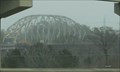 view gallery view gallerySW23.7 km |  O. K. Allen US 71 Bridge - Alexandria LA O. K. Allen US 71 Bridge - Alexandria LA
in Truss Bridges The O.K. Allen US 71 truss bridge over the Red River north of Alexandria LA is being replaced. This bridge's days are numbered, so check it out while you still can! posted by: Benchmark Blasterz location: Louisiana date approved: 02/27/2015 last visited: 01/01/2015 |
|