 view gallery view gallery W2.9 km W2.9 km
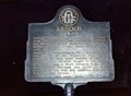
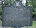
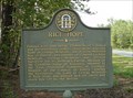
|   Ardoch GHM 095-16 Ardoch GHM 095-16
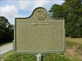
in Georgia Historical Markers Located on US 17 at Ardick Rd, north of Darien. posted by:  Markerman62 Markerman62 location: Georgia date approved: 10/30/2015 last visited: 11/08/2015 |
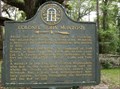
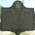 view gallery view galleryW3.5 km | Old Meeting House 095-22 - McIntosh County, GA in Georgia Historical Markers The "Old Meeting House 095-22" Historical Marker is located on US 17 a half mile south of County Road 21 between Eulonia and Ardick. posted by:  onfire4jesus onfire4jesus location: Georgia date approved: 04/12/2008 last visited: 09/01/2001 |
 view gallery view gallery NW4 km NW4 km
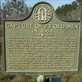
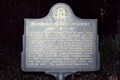
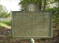
| Capture of 23 Old Men in 1864 095-33 - McIntosh County, GA in Georgia Historical Markers The "Capture of 23 Old Men in 1864" Historical Marker is located on US 17 near the corner of County Road 21 between Eulonia and Ardick. posted by: onfire4jesus location: Georgia date approved: 04/12/2008 last visited: 09/01/2001 |
 view gallery view gallery SE4.5 km SE4.5 km
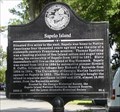
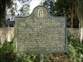
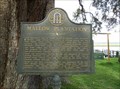
| Sapelo Island Historical Marker in Georgia Historical Markers Sapelo Island Historical Marker at the Sapelo Island Visitors Center off Ga Hwy 99 posted by: onfire4jesus location: Georgia date approved: 06/27/2007 last visited: 08/10/2013 |
 view gallery view gallery S4.8 km S4.8 km
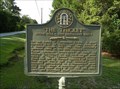
| “The Thicket” Sugar Mill – Rum Distillery Ruins Historical Marker in Georgia Historical Markers “The Thicket” Sugar Mill – Rum Distillery Ruins Historical Marker on Ga Hwy 99 5.4 miles east of US 17 near Ridgeville, Ga posted by: onfire4jesus location: Georgia date approved: 06/27/2007 last visited: 09/01/2001 |
 view gallery view galleryNW5.3 km |  Basketball Court at Shorter Chapel Park - Townsend, Georgia Basketball Court at Shorter Chapel Park - Townsend, Georgia
in Outdoor Basketball Courts The basketball court at Shorter Chapel Park is north of the Shorter Chapel AME Church in Townsend, Georgia. posted by: 401Photos location: Georgia date approved: 04/01/2023 last visited: never |
 view gallery view gallery NE5.8 km NE5.8 km
| Baisden's Bluff Academy GHM 095-12 in Georgia Historical Markers Located on GA 99 at Donelly Rd in the community of Crescent. posted by: Markerman62 location: Georgia date approved: 10/30/2015 last visited: 11/08/2015 |
 view gallery view gallery N6.4 km N6.4 km
|  Townsend, GA 31331 Townsend, GA 31331
in U.S. Post Offices Located near I95, a small post office in a small town. posted by: ChapterhouseInc location: South Carolina date approved: 09/14/2010 last visited: 05/15/2010 |
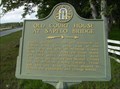 view gallery view galleryN7.2 km | Old Court House at Sapelo Bridge Historical Marker in Georgia Historical Markers Old Court House at Sapelo Bridge Historical Marker on US 17/Ga 25 0.8 mile North of Eulonia, GA posted by: onfire4jesus location: Georgia date approved: 06/27/2007 last visited: 09/01/2001 |
 view gallery view galleryNE8.2 km | Old Belleville or Troup Cemetery Historical Marker in Georgia Historical Markers Old Belleville or Troup Cemetery Historical Marker in Crescent, Ga, 0.5 mile left of road from Ga Hwy 99 to Pelican Point posted by: onfire4jesus location: Georgia date approved: 06/27/2007 last visited: 09/01/2001 |
 view gallery view galleryN8.7 km | Captain William McIntosh Historical Marker in Georgia Historical Markers Captain William McIntosh Historical Marker in cemetery on Fairhope Rd in Pine Harbor, GA posted by: onfire4jesus location: Georgia date approved: 06/27/2007 last visited: 09/01/2001 |
 view gallery view galleryN8.7 km | Colonel John McIntosh Historical Marker in Georgia Historical Markers Colonel John McIntosh Historical Marker in Cemetery on Fairhope Rd in Pine Harbor, GA posted by: onfire4jesus location: Georgia date approved: 06/27/2007 last visited: 09/01/2001 |
 view gallery view galleryN8.9 km | Mallow Plantation Historical Marker in Georgia Historical Markers Mallow Plantation Historical Marker at the end of Pine Harbor Rd in Pine Harbor, GA posted by: onfire4jesus location: Georgia date approved: 06/27/2007 last visited: 09/01/2001 |
 view gallery view galleryN9 km | John Houstoun McIntosh Historical Marker in Georgia Historical Markers John Houstoun McIntosh Historical Marker on US 17/Ga 25 2 miles North of Eulonia, Ga posted by: onfire4jesus location: Georgia date approved: 06/27/2007 last visited: 09/01/2001 |
 view gallery view galleryN9 km | Rice Hope Historical Marker in Georgia Historical Markers Rice Hope Historical Marker on US 17/Ga 25 2 miles North of Eulonia, GA posted by: onfire4jesus location: Georgia date approved: 06/27/2007 last visited: 09/01/2001 |
 view gallery view gallery SW9 km SW9 km
|  Hwy 251 KFC - Darien, GA Hwy 251 KFC - Darien, GA
in Kentucky Fried Chicken/KFC Restaurants KFC/Taco Bell/Pizza Hut just off I95. posted by: ChapterhouseInc location: Georgia date approved: 07/25/2009 last visited: 06/28/2009 |
 view gallery view gallerySW9 km |  Hwy 251 Taco Bell - Darien, GA Hwy 251 Taco Bell - Darien, GA
in Taco Bell Restaurants KFC/Taco Bell/Pizza Hut just off I95. posted by: ChapterhouseInc location: Georgia date approved: 07/25/2009 last visited: 06/28/2009 |
 view gallery view gallerySW9 km |  Hwy 251 Pizza Hut - Darien, GA Hwy 251 Pizza Hut - Darien, GA
in Pizza Hut Restaurants KFC/Taco Bell/Pizza Hut just off I95. posted by: ChapterhouseInc location: Georgia date approved: 07/25/2009 last visited: 06/28/2009 |
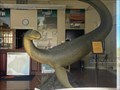 view gallery view gallerySW9.5 km |  Altamaha-ha - Darien, Georgia Altamaha-ha - Darien, Georgia
in Epic Beings and Creatures Altamaha-ha has been reported to live in the Altamaha River of southeastern Georgia for at least the past four centuries. A large statue of Altie is featured in the Darien Visitor Center. posted by: 401Photos location: Georgia date approved: 05/05/2021 last visited: never |
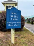 view gallery view gallerySW9.5 km |  7 MPH speed limit - Darien, Georgia 7 MPH speed limit - Darien, Georgia
in Unusual Speed Limits The posted limit of this Darien, Georgia, plaza is established to protect pedestrians -- seven miles per hour. posted by: 401Photos location: Georgia date approved: 06/15/2021 last visited: never |
 view gallery view galleryS9.8 km | Old River Road Historical Marker in Georgia Historical Markers Old River Road Historical Marker on US 17/GA 25 at Jct with Hwy 251 1 mile North of Darien, GA posted by: onfire4jesus location: Georgia date approved: 06/16/2007 last visited: 09/01/2001 |
 view gallery view galleryS9.8 km |  Old River Road - Darien, GA Old River Road - Darien, GA
in Wagon Roads and Trails This road began as a military road used by the Scottish highlanders to invade Spanish Florida. posted by: onfire4jesus location: Georgia date approved: 09/06/2007 last visited: 05/01/2009 |
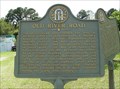
 view gallery view galleryS9.8 km | Fort Barrington Historical Marker in Georgia Historical Markers Fort Barrington Historical Marker on US 17/GA 25 at Jct with Hwy 251 1 mile north of Darien, GA posted by: onfire4jesus location: Georgia date approved: 06/16/2007 last visited: 09/01/2001 |
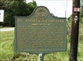 view gallery view galleryS10.5 km | St. Andrew’s Cemetery Historical Marker in Georgia Historical Markers St. Andrew’s Cemetery Historical Marker on Ga Hwy 99 1.4 miles East of US 17 in Darien, Ga posted by: onfire4jesus location: Georgia date approved: 06/27/2007 last visited: 09/01/2001 |
 view gallery view galleryS11.3 km | Birthplace of John McIntosh Kell Historical Marker in Georgia Historical Markers Birthplace of John McIntosh Kell Historical Marker on Ga Hwy 99 0.8 miles East of US 17 near Fort King George Historical Site in Darien, Ga posted by: onfire4jesus location: Georgia date approved: 06/27/2007 last visited: 09/01/2001 |
|