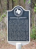
 view gallery view gallery NW5.3 km NW5.3 km
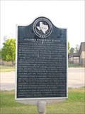
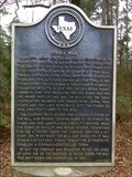
|   Hagerville Community Hagerville Community
in Texas Historical Markers A marker describing the history of a small town. posted by:  txoilgas txoilgas location: Texas date approved: 11/11/2010 last visited: 06/07/2015 |
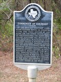 view gallery view galleryNW5.5 km | Community of Coltharp in Texas Historical Markers A marker describes what it took to build a community. posted by: txoilgas location: Texas date approved: 11/11/2010 last visited: 06/07/2015 |
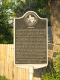 view gallery view galleryNW5.6 km | Kennard in Texas Historical Markers A marker about the city. posted by: txoilgas location: Texas date approved: 11/11/2010 last visited: 06/02/2015 |
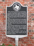 view gallery view galleryNW5.6 km | First Baptist Church of Kennard in Texas Historical Markers Locatednear the entrance to the church. posted by: txoilgas location: Texas date approved: 11/15/2010 last visited: 06/02/2015 |
 view gallery view galleryNW5.6 km | Former Rosenwald School in Texas Historical Markers A marker about the early funding of schools for Black students. posted by: txoilgas location: Texas date approved: 11/11/2010 last visited: 06/02/2015 |
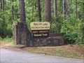 view gallery view galleryNW5.6 km |  Ratcliff Lake Recreation Area - Kennard, TX Ratcliff Lake Recreation Area - Kennard, TX
in Civilian Conservation Corps This is part of the Davy Crockett National Forest. The Living New Deal has it listed twice on their website. posted by:  WalksfarTX WalksfarTX location: Texas date approved: 07/27/2020 last visited: 12/21/2022 |
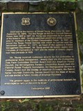 view gallery view galleryNW5.8 km |  Donald Young - Kennard, TX Donald Young - Kennard, TX
in Citizen Memorials Bronze plaque on rock pillar on the right side of road just past the park entrance gate and the stop to register kiosk. posted by: WalksfarTX location: Texas date approved: 07/27/2020 last visited: 12/21/2022 |
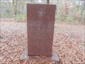 view gallery view galleryNW6 km | Steve Wester, Scott Stephens, Chris Philips - Ratcliff Lake Recreation Area, Kennard, TX USA in Citizen Memorials Sadly, this is a memorial of the three 13 year old Boy Scouts who died in 1973 when a huge pine tree unexpectedly fell over upon the tent these three young teens happened to be in at the time!! posted by: WayBetterFinder location: Texas date approved: 12/22/2022 last visited: 12/26/2022 |
 view gallery view gallery N6 km N6 km
| Four C Mill in Texas Historical Markers On Hwy 7 near Ratcliff, Texas and near Ratcliff Recreation area where the trailhead for one end of the 20 mile 4C National Hiking Trail may be found. posted by: jackrock location: Texas date approved: 01/19/2010 last visited: 05/30/2015 |
 view gallery view gallery S17.9 km S17.9 km
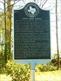
| Scrub Creek School in Texas Historical Markers There is a historical marker sign indicating the turn off Hwy 358 for this one. Go down a short ways and it will be on the left. posted by: jackrock location: Texas date approved: 01/24/2010 last visited: never |
 view gallery view gallery SW19.5 km SW19.5 km
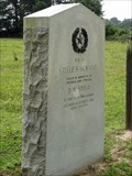
| Site of Steele's Academy in Texas Historical Markers Gray granite marker along F.M. 2781. posted by: WalksfarTX location: Texas date approved: 05/28/2017 last visited: 08/21/2015 |
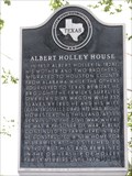 view gallery view gallerySW19.6 km | Albert Holley House in Texas Historical Markers This subject marker stands on the north side of US 287 S, northwest of Pennington, TX. posted by: QuesterMark location: Texas date approved: 01/30/2010 last visited: 06/10/2009 |
 view gallery view galleryNW21.1 km |  El Camino Real -- DAR Marker No. 26, SH 21 nr FM 1733, Houston Co. TX El Camino Real -- DAR Marker No. 26, SH 21 nr FM 1733, Houston Co. TX
in Wagon Roads and Trails No. 26 of 128 pink granite El Camino Real markers placed by the Daughters of the American Revolution in 1918 stands along the route of the Old San Antonio Road along the SH 21 near the FM 1733, in Houston Co. TX posted by: Benchmark Blasterz location: Texas date approved: 01/27/2018 last visited: 12/30/2017 |
 view gallery view galleryNW21.1 km |  El Camino Real -- DAR Marker No. 26, SH 21 nr FM 1733, Houston Co. TX El Camino Real -- DAR Marker No. 26, SH 21 nr FM 1733, Houston Co. TX
in Ancient Traces and Roads No. 26 of 128 pink granite El Camino Real markers placed by the Daughters of the American Revolution in 1918 stands along the route of the Old San Antonio Road along the SH 21 near the FM 1733, in Houston Co. TX posted by: Benchmark Blasterz location: Texas date approved: 01/27/2018 last visited: 12/30/2017 |
 view gallery view galleryNW21.1 km |  El Camino Real de los Tejas -- DAR Marker No. 26, SH 21 nr FM 1733, Houston Co. TX El Camino Real de los Tejas -- DAR Marker No. 26, SH 21 nr FM 1733, Houston Co. TX
in National Scenic Byways No. 26 of 128 pink granite El Camino Real markers placed by the Daughters of the American Revolution in 1918 stands along the route of the Old San Antonio Road along the SH 21 near the FM 1733, in Houston Co. TX posted by: Benchmark Blasterz location: Texas date approved: 01/27/2018 last visited: 12/30/2017 |
 view gallery view galleryNW21.1 km |  King's Highway DAR Marker #26 -- SH 21 near JCT with FM 1733, Houston Co., TX, USA King's Highway DAR Marker #26 -- SH 21 near JCT with FM 1733, Houston Co., TX, USA
in Daughters of the American Revolution No. 26 of 118 pink granite markers erected by the Texas Society of the Daughters of The American Revolution and the State of Texas along the route of the Old Spanish Road from the Louisiana border to the Mexican border posted by: Benchmark Blasterz location: Texas date approved: 05/05/2023 last visited: 05/06/2023 |
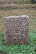 view gallery view galleryNW21.1 km | King's Highway in Texas Historical Markers No. 26 of 118 pink granite markers erected by the Daughters of The American Revolution and the State of Texas along the route of the Old Spanish Road posted by: Benchmark Blasterz location: Texas date approved: 01/28/2018 last visited: 12/30/2017 |
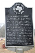 view gallery view galleryNW21.1 km | New Energy Cemetery in Texas Historical Markers New Energy Cemetery, along State Highway 21 in Houston Co. TX posted by: Benchmark Blasterz location: Texas date approved: 01/29/2018 last visited: never |
 view gallery view galleryNW21.1 km |  New Energy Cemetery -- Houston Co. TX New Energy Cemetery -- Houston Co. TX
in Worldwide Cemeteries New Energy Cemetery, along State Highway 21 in Houston Co. TX posted by: Benchmark Blasterz location: Texas date approved: 01/28/2018 last visited: 12/30/2017 |
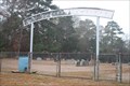
 view gallery view galleryNW21.1 km |  New Energy Cemetery Arch -- Houston Co. TX New Energy Cemetery Arch -- Houston Co. TX
in Freestanding Arches The freestanding arch for New Energy Cemetery, along State Highway 21 in Houston Co. TX posted by: Benchmark Blasterz location: Texas date approved: 01/28/2018 last visited: 12/30/2017 |
 view gallery view galleryNW21.6 km | Pine Springs Campground in Texas Historical Markers This marker is right off Hwy 21 (following El Camino Real) in the Davy Crockett National Forest. posted by: jackrock location: Texas date approved: 01/19/2010 last visited: 12/30/2017 |
 view gallery view galleryNW21.6 km | El Camino Real -- Pine Springs Campground, Cherokee Co. TX in Wagon Roads and Trails A well-known campground along the El Camino Real de los Tejas, known for its free-flowing springs posted by: Benchmark Blasterz location: Texas date approved: 01/26/2018 last visited: 12/30/2017 |
 view gallery view galleryNW21.6 km | El Camino Real de los Tejas -- Pine Springs Campground, Cherokee Co. TX in National Scenic Byways A well-known campground along the El Camino Real de los Tejas, known for its free-flowing springs posted by: Benchmark Blasterz location: Texas date approved: 01/27/2018 last visited: 12/30/2017 |
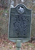 view gallery view galleryNW21.6 km | El Camino Real -- Pine Springs Campground, Cherokee Co. TX in Ancient Traces and Roads A well-known campground along the El Camino Real de los Tejas, known for its free-flowing springs posted by: Benchmark Blasterz location: Texas date approved: 01/27/2018 last visited: 12/30/2017 |
 view gallery view galleryNW22.2 km | King's Highway in Texas Historical Markers No. 25 of 118 pink granite markers erected by the Daughters of The American Revolution and the State of Texas along the route of the Old Spanish Road posted by: Benchmark Blasterz location: Texas date approved: 01/26/2018 last visited: 12/30/2017 |
|