 view gallery view gallery NE12.6 km NE12.6 km
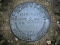
|   USGS survey mark 1971, near Megargel, AL USGS survey mark 1971, near Megargel, AL
in U.S. Benchmarks A USGS vertical control mark, third order or better with tablet. posted by:  jkselby jkselby location: Alabama date approved: 12/05/2007 last visited: never |
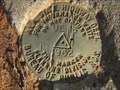 view gallery view galleryNE12.6 km | Ala. State Hwy. Dept. UE 13 1962 in U.S. Benchmarks An Ala. State Highway Dept. survey mark located on AL 21, north of Megargel, Alabama. posted by: jkselby location: Alabama date approved: 12/05/2007 last visited: never |
 view gallery view gallery N12.6 km N12.6 km
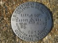
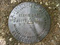
| U.S. Geological Survey elevation marker 301 FT 92 RAP 1971 in U.S. Benchmarks USGS vertical control mark at Pleasant Hill Church posted by: jkselby location: Alabama date approved: 12/02/2009 last visited: never |
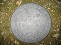
 view gallery view galleryN12.9 km | US Geological Survey elevation marker 184 FT 67 RAP 1971 in U.S. Benchmarks USGS elevation marker about 0.5 mile south of Shiloh Church posted by: jkselby location: Alabama date approved: 05/02/2008 last visited: never |
 view gallery view gallery NW13 km NW13 km
| US Geological Survey elevation marker 147 FT 107 RAP 1971 in U.S. Benchmarks USGS elevation marker at Morning Star Church posted by: jkselby location: Alabama date approved: 11/04/2009 last visited: never |
 view gallery view galleryN13.8 km | US Geological Survey elevation marker 180 FT 66 RAP 1971 in U.S. Benchmarks USGS elevation benchmark near Shiloh Church posted by: jkselby location: Alabama date approved: 04/01/2008 last visited: never |
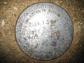
 view gallery view galleryN14 km | U.S. Geological Survey vertical control mark 93 RAP 1971 in U.S. Benchmarks USGS marker south of Manistee, Monroe County posted by: jkselby location: Alabama date approved: 08/14/2009 last visited: never |
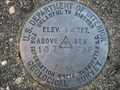
 view gallery view galleryNE14.3 km | US Geological Survey elevation marker 404 FT 86 RAP 1971 in U.S. Benchmarks USGS elevation mark 2 miles SW of Frisco City, Alabama posted by: jkselby location: Alabama date approved: 12/21/2007 last visited: never |
 view gallery view galleryNW15.6 km | US Geological Survey elevation marker 136 FT 105 RAP 1971 in U.S. Benchmarks USGS elevation marker on CR 1 near Eliska Church posted by: jkselby location: Alabama date approved: 11/04/2009 last visited: never |
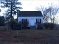
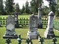
 view gallery view galleryNE17.4 km |  Shiloh Primitive Baptist Church Cemetery - Frisco City, AL Shiloh Primitive Baptist Church Cemetery - Frisco City, AL
in Alabama Historical Markers Describes the history of the cemetery on Shiloh Street and its still standing historic church that was restored in 2010 and is the oldest building in the city. posted by: hoteltwo location: Alabama date approved: 07/17/2024 last visited: never |
 view gallery view gallery W17.9 km W17.9 km
| Mt. Pleasant Methodist Church - near Uriah, AL in Alabama Historical Markers Notes the architecture and history of the building of this Methodist Church. It also describes the local industry that sprouted up in the community around this old church. posted by: hoteltwo location: Alabama date approved: 07/17/2024 last visited: never |
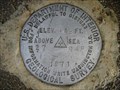 view gallery view galleryNE18.7 km | US Geological Survey elevation marker 413 FT 27 RAP 1971 in U.S. Benchmarks USGS vertical control mark 1 mile NE of Frisco City, AL posted by: jkselby location: Alabama date approved: 12/21/2007 last visited: never |
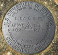 view gallery view galleryW19 km | U.S. Geological Survey elevation marker 62 FT 102 RAP 1971 in U.S. Benchmarks USGS elevation mark 2.8 miles north of Chrysler, Monroe County posted by: jkselby location: Alabama date approved: 11/24/2009 last visited: never |
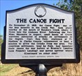 view gallery view galleryNW20.6 km | The Canoe Fight - Gainestown, AL in Alabama Historical Markers Marker located along Madison Road (County Road 33), east of Gainestown, describes the Creek War incident between Creek Indians and militiamen of the area forts. posted by: hoteltwo location: Alabama date approved: 03/02/2017 last visited: never |
 view gallery view galleryN23.5 km |  Perdue Hill, AL 36470 Perdue Hill, AL 36470
in U.S. Post Offices Located inside a gas station store this rural post office serves about 300 mailboxes in the area. posted by: hoteltwo location: Alabama date approved: 12/06/2013 last visited: never |
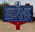 view gallery view galleryN23.5 km | Lafayette's Tour - Perdue Hill, AL in Alabama Historical Markers From July 1824 to September 1825, the Marquis de Lafayette, the last surviving French general of the American Revolutionary War, made a tour of the 24 states in the United States. posted by: hoteltwo location: Alabama date approved: 03/12/2024 last visited: never |
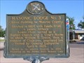 view gallery view galleryN23.5 km | Masonic Lodge #3 in Alabama Historical Markers Built in 1824 - oldest building in Monroe County. posted by: Thorny1 location: Alabama date approved: 07/11/2008 last visited: 08/27/2019 |
 view gallery view galleryN23.7 km |  William Barret Travis Home - Perdue Hill, AL William Barret Travis Home - Perdue Hill, AL
in Relocated Structures Relocated home of the Texas hero and commander of the Alamo, William Travis. posted by: hoteltwo location: Alabama date approved: 12/10/2013 last visited: never |
 view gallery view galleryNW23.7 km |  Gainestown Methodist Church and Cemetery - Gainestown, Alabama Gainestown Methodist Church and Cemetery - Gainestown, Alabama
in Wikipedia Entries Historic church and cemetery located near the small community of Gainestown, Alabama. posted by:  BruceS BruceS location: Alabama date approved: 09/24/2013 last visited: never |
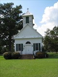 view gallery view galleryNW23.7 km |  Gainestown Methodist Church and Cemetery - Gainestown, Alabama Gainestown Methodist Church and Cemetery - Gainestown, Alabama
in U.S. National Register of Historic Places Historic church and cemetery located near the small community of Gainestown, Alabama. posted by: BruceS location: Alabama date approved: 10/31/2009 last visited: never |
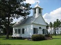 view gallery view galleryNW23.7 km |  Gainestown United Methodist Church - Gainestown, Alabama Gainestown United Methodist Church - Gainestown, Alabama
in Methodist Churches Historic Methodist church located near the small community of Gainestown, Alabama. posted by: BruceS location: Alabama date approved: 10/31/2009 last visited: never |
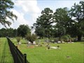 view gallery view galleryNW23.8 km |  Gainestown Methodist Church and Cemetery - Gainestown, Alabama Gainestown Methodist Church and Cemetery - Gainestown, Alabama
in Churchyard Cemeteries Historic church and cemetery located near the small community of Gainestown, Alabama. posted by: BruceS location: Alabama date approved: 11/01/2009 last visited: never |
 view gallery view galleryNW23.8 km |  Gainestown Methodist Church Cemetery - Gainestown, Alabama Gainestown Methodist Church Cemetery - Gainestown, Alabama
in Worldwide Cemeteries Historic cemetery located near the small community of Gainestown, Alabama. posted by: BruceS location: Alabama date approved: 11/04/2009 last visited: never |
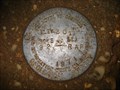
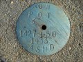 view gallery view galleryNE23.8 km | 1427 + 50 in U.S. Benchmarks Alabama State Highway Dept. ROW marker on AL 47 near Mexia, Alabama posted by: jkselby location: Alabama date approved: 12/15/2007 last visited: never |
 view gallery view galleryNE23.8 km |  Lambert's - Foley, Alabama Lambert's - Foley, Alabama
in Independent Diners Lambert's - Home of the Thrown Rolls, Lambert's Foley, Alabama, location. posted by: gwtriker location: Alabama date approved: 06/03/2010 last visited: 03/06/2015 |
|