 view gallery view gallery SW3.9 km SW3.9 km
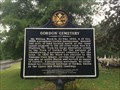
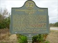
|   Gordon Cemetery / Early Gordon Leaders - Gordon, AL Gordon Cemetery / Early Gordon Leaders - Gordon, AL
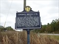
in Alabama Historical Markers Marker north of Gordon, on Alabama 95, notes the early leaders of the town and establishment of the cemetery. posted by:  hoteltwo hoteltwo location: Alabama date approved: 05/04/2014 last visited: 08/05/2014 |
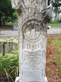 view gallery view gallerySW3.9 km |  Daniel Smith - Gordon Cemetery - Gordon, AL Daniel Smith - Gordon Cemetery - Gordon, AL
in Woodmen of the World Grave Markers/Monuments Located in a rural cemetery, north of Gordon, on Alabama Route 95 this is a standard WOW tree stone. posted by: hoteltwo location: Alabama date approved: 05/10/2014 last visited: never |
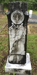 view gallery view gallerySW4 km | WJ Poole - Gordon Cemetery - Gordon, AL in Woodmen of the World Grave Markers/Monuments Located in a rural cemetery, north of Gordon, on Alabama Route 95 this is a smaller WOW tree stone for W.J. Pool. posted by: hoteltwo location: Alabama date approved: 05/10/2014 last visited: never |
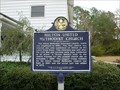
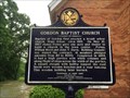 view gallery view gallerySW4.5 km | Gordon Baptist Church - Gordon, AL in Alabama Historical Markers Marker located in front of this rural town's Baptist Church on Leslie Street just off Alabama Route 95 describes the history of the church. posted by: hoteltwo location: Alabama date approved: 05/04/2014 last visited: 08/05/2014 |
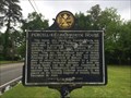
 view gallery view gallery S6.3 km S6.3 km
|  GA/AL on US 84 near Gordon, Alabama GA/AL on US 84 near Gordon, Alabama
in Border Crossings U.S. Highway 84 runs east-west when it crosses the border between Georgia and Alabama. The actual border is located just west of the Chattahoochee River where the bridge ends. posted by:  xptwo xptwo location: Alabama date approved: 03/12/2012 last visited: never |
 view gallery view gallery NW6.8 km NW6.8 km
|  Joseph M. Farley Nuclear Plant Joseph M. Farley Nuclear Plant
in Nuclear Power Plants Working nuclear plant. posted by: mitzi_c location: Alabama date approved: 01/08/2023 last visited: 01/08/2023 |
 view gallery view gallery SE8.4 km SE8.4 km
|  Confederate Navy Yard, Saffold-GHM 049-9-Early Co Confederate Navy Yard, Saffold-GHM 049-9-Early Co
in Georgia Historical Markers US 84 about 3.5 miles west of Jakin at the river posted by: Sprinterman location: Georgia date approved: 01/23/2011 last visited: 09/08/2023 |
 view gallery view gallery W10.1 km W10.1 km
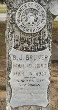
| B J Bruner - Liberty Cemetery - Pansey, AL in Woodmen of the World Grave Markers/Monuments Located in a rural cemetery, west of Pansey, at the intersection of Liberty and Dillard Roads, this is a standard WOW tree stone for BJ Bruner. posted by: hoteltwo location: Alabama date approved: 05/10/2014 last visited: never |
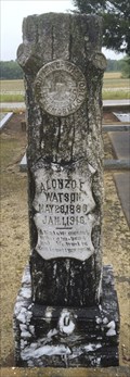 view gallery view galleryW10.1 km | Alonzo E Watson - Liberty Cemetery - Pansey, AL in Woodmen of the World Grave Markers/Monuments Located in a rural cemetery, west of Pansey, at the intersection of Liberty and Dillard Roads, this is a standard WOW tree stone for Alonzo Watson. posted by: hoteltwo location: Alabama date approved: 05/10/2014 last visited: never |
 view gallery view galleryW10.1 km | Liberty Baptist Church - Pansey, AL in Alabama Historical Markers This marker is located in front of the Liberty Baptist church at the intersection of Liberty & Dillard Road. A large cemetery is located to the rear of the church. posted by: hoteltwo location: Alabama date approved: 05/04/2014 last visited: 05/14/2021 |
 view gallery view gallery N12.2 km N12.2 km
| Covered Bridge 2 Miles-HCC-Early County in Georgia Historical Markers Ga 62 at Old River Road at Hilton posted by: Sprinterman location: Georgia date approved: 01/24/2011 last visited: 08/05/2014 |
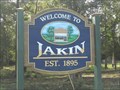 view gallery view gallerySE12.9 km |  Jakin, Georgia Jakin, Georgia
in Artistic Welcome Signs This welcome sign for the city of Jakin, which is located in Early County Georgia, USA, is located on the west end of the city on Highway 84. posted by: Marine Biologist location: Georgia date approved: 10/07/2012 last visited: never |
 view gallery view galleryN12.9 km | Hilton United Methodist Church-HCC-Early Co in Georgia Historical Markers At church in Hilton on road to Coheelee Park posted by: Sprinterman location: Georgia date approved: 01/27/2011 last visited: 08/05/2014 |
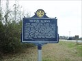 view gallery view galleryN13 km | Hilton School-HCC-Early Co in Georgia Historical Markers Ga 62 at Hilton posted by: Sprinterman location: Georgia date approved: 01/27/2011 last visited: 08/05/2014 |
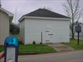 view gallery view galleryN13 km |  Old Columbia Jail Old Columbia Jail
in Retired Prisons This old jail is located in Columbia, Alabama. posted by: driver8 location: Alabama date approved: 08/31/2006 last visited: 08/05/2014 |
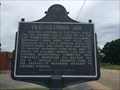 view gallery view galleryN13 km | Old Columbia Jail / Columbia - Columbia, AL in Alabama Historical Markers Marker with two sides, one about the City of Columbia, and the other about one of the oldest wooden jails still around in Alabama. Located just south of State Route 52 near the public library. posted by: hoteltwo location: Alabama date approved: 05/06/2014 last visited: 08/05/2014 |
 view gallery view galleryN13.2 km | Columbia Methodist Episcopal Church, South - Columbia, AL in Alabama Historical Markers Located at the corner of Church Street and South Davis Street this marker describes the early beginnings of this Methodist Episcopal Church. posted by: hoteltwo location: Alabama date approved: 05/06/2014 last visited: 08/05/2014 |
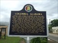 view gallery view galleryN13.2 km | Columbia, Alabama in Alabama Historical Markers Marker placed as part of the Great Alabama Homecoming of 2010 honoring small cities and towns, it notes the early history of Columbia, Alabama. posted by: hoteltwo location: Alabama date approved: 05/06/2014 last visited: 08/05/2014 |
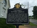 view gallery view galleryN13.4 km | Columbia Baptist Church in Alabama Historical Markers Located on Main St., just above Church St., the church serves a community that once was a thriving trade center. posted by: hoteltwo location: Alabama date approved: 05/06/2014 last visited: 08/05/2014 |
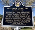 view gallery view galleryN13.4 km | Columbia Cemetery - Columbia, Alabama in Alabama Historical Markers Marker is located within the cemetery, this double-sided marker on West Church Street notes how the land was acquired for the cemetery and the history of some of those interred. posted by: hoteltwo location: Alabama date approved: 04/10/2018 last visited: never |
 view gallery view gallery NE13.5 km NE13.5 km
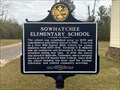
| Sowhatchee Elementary School in Georgia Historical Markers Located at Still Road and Zion Church Road, outside of Blakely. posted by: Markerman62 location: Georgia date approved: 03/21/2022 last visited: never |
 view gallery view galleryN13.7 km | Purcell - Killingsworth House - Columbia, AL in Alabama Historical Markers Now the Garden Path Inn bed & breakfast, this historic residence in Columbia is located on North Main Street just north of State Route 52. posted by: hoteltwo location: Alabama date approved: 05/06/2014 last visited: 08/05/2014 |
 view gallery view galleryN14.2 km | Historic Marker, Fannie Askew Williams Park, Early County,GA in Georgia Historical Markers Another reason to visit the Coheelee Covered Bridge. posted by: BackPak location: Georgia date approved: 09/04/2006 last visited: 08/05/2014 |
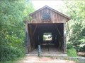 view gallery view galleryN14.2 km |  Coheelee Creek Covered Bridge Coheelee Creek Covered Bridge
in Covered Bridges The southernmost covered bridge in the United States. posted by: driver8 location: Georgia date approved: 04/15/2006 last visited: 02/25/2017 |
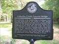 view gallery view galleryN14.2 km | Coheelee Creek Covered Bridge - GHS 49-1 - Early County in Georgia Historical Markers Well worth the trip take a picnic lunch and stay awhile. posted by: BackPak location: Georgia date approved: 09/03/2006 last visited: 02/25/2017 |
|