 view gallery view gallery N9.7 km N9.7 km
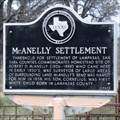
|   McAnelly Settlement McAnelly Settlement
in Texas Historical Markers This little old marker stands in Lometa on FM 580 where County Road 355 and County Road 1720 intersect it. posted by:  QuesterMark QuesterMark location: Texas date approved: 11/27/2016 last visited: 11/25/2016 |
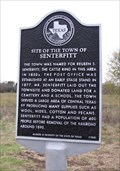 view gallery view galleryN18.2 km | Site of the Town of Senterfitt in Texas Historical Markers This post-mounted subject marker stands at the intersection of County Road 1436 and FM 581 a little over 3 miles southwest of Lometa. posted by: QuesterMark location: Texas date approved: 10/26/2020 last visited: never |
 view gallery view galleryN18.7 km | Senterfitt Cemetery in Texas Historical Markers This subject marker is mounted on a frame next to a map of the cemetery, underneath a roof, within the cemetery, off FM 581 a few miles southwest of Lometa. posted by: QuesterMark location: Texas date approved: 11/01/2020 last visited: never |
 view gallery view galleryN20.6 km | Phantom Hill Road in Texas Historical Markers State historic marker located west of Lometa on the US 190 posted by: Benchmark Blasterz location: Texas date approved: 10/21/2015 last visited: 06/12/2021 |
 view gallery view galleryN20.6 km |  FIRST -- Road in Lamapas County, US190 W of Lometa TX FIRST -- Road in Lamapas County, US190 W of Lometa TX
in First of its Kind A state historic marker located west of Lometa TX on the US 190 preserves the history of an important early Texas frontier road, and the first road in what became Lamapasas County. posted by: Benchmark Blasterz location: Texas date approved: 10/14/2015 last visited: 06/12/2021 |
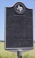 view gallery view galleryN20.6 km |  Fort Phantom Hill Road -- US 190 W of Lometa TX Fort Phantom Hill Road -- US 190 W of Lometa TX
in Ancient Traces and Roads A state historic marker located west of Lometa on the US 190 preserves the history of an important early Texas frontier road. posted by: Benchmark Blasterz location: Texas date approved: 10/13/2015 last visited: 06/12/2021 |
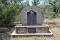
 view gallery view gallery NE20.8 km NE20.8 km
| C.S.A. Salt Works in Texas Historical Markers This historic marker stands near the site of a Confederate salt works near the town of Lometa posted by: Benchmark Blasterz location: Texas date approved: 10/21/2015 last visited: 07/25/2015 |
 view gallery view galleryNE20.8 km | Pleasant Valley Farmers' Alliance No. 1 in Texas Historical Markers This marker tells of the formation of a farmers' union that also influenced a political party in the 1890s. posted by: WayBetterFinder location: Texas date approved: 09/23/2015 last visited: 07/24/2015 |
 view gallery view galleryNE20.8 km | FIRST -- Farmer's Alliance chapter in Texas, US 183 W of Lampasas TX in First of its Kind The first Farmer's Alliance chapter in Texas sparked a short-lived populist political movement posted by: Benchmark Blasterz location: Texas date approved: 10/13/2015 last visited: 07/25/2015 |
 view gallery view galleryN21.2 km |  Chadwick TX Chadwick TX
in Ghost Towns A state historic marker affixed to the millstone from the former site of Chadwick's Mill on the US 190 at the Colorado River is almost all the remains of what used to be a thriving community. posted by: Benchmark Blasterz location: Texas date approved: 10/14/2015 last visited: 04/14/2018 |
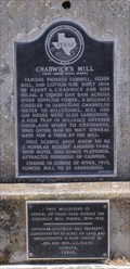 view gallery view galleryN21.2 km | Chadwick's Mill in Texas Historical Markers A state historic marker at the former site of Chadwick's Mill on the US 190 at the Colorado River posted by: Benchmark Blasterz location: Texas date approved: 10/21/2015 last visited: 04/14/2018 |
 view gallery view galleryN21.2 km |  Chadwick's Millstone -- US 190 at Colorado River, Lampasas Co. TX Chadwick's Millstone -- US 190 at Colorado River, Lampasas Co. TX
in Millstones A state historic marker affixed to the millstone from the former site of Chadwick's Mill on the US 190 at the Colorado River posted by: Benchmark Blasterz location: Texas date approved: 10/13/2015 last visited: 04/14/2018 |
 view gallery view galleryN21.2 km |  US 190 Colorado River Bridge -- US 190 at Lampasas/San Saba County Line, TX US 190 Colorado River Bridge -- US 190 at Lampasas/San Saba County Line, TX
in U.S. National Register of Historic Places The US 190 Colorado River bridge is listed on the US National Register of Historic Places. posted by: Benchmark Blasterz location: Texas date approved: 10/14/2015 last visited: 04/14/2018 |
 view gallery view galleryN21.2 km |  US 190 Bridge at the Colorado River -- Lometa, TX US 190 Bridge at the Colorado River -- Lometa, TX
in WPA Projects A 1940 cantilevered Warren through truss bridge carried US 190 over the Colorado River between San Saba and Lampasas counties in TX. This bridge was built by the Federal Works Agency, and is listed on the US National Register of Historic Places. posted by: Benchmark Blasterz location: Texas date approved: 04/17/2018 last visited: 07/24/2015 |
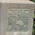 view gallery view galleryN21.2 km |  Colorado River Bridge - 1940 - Lometa, TX Colorado River Bridge - 1940 - Lometa, TX
in Bridge Date Stones and Plaques A cantilevered Warren through truss bridge over the Colorado River between San Saba and Lampasas counties in TX, built in 1940. This bridge is listed on the US National Register of Historic Places. posted by: Benchmark Blasterz location: Texas date approved: 10/14/2015 last visited: 06/12/2021 |
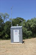 view gallery view galleryN21.2 km |  LCRA/USGS Colorado River Gauge -- US 190 at Lampasas/San Saba County Line, TX LCRA/USGS Colorado River Gauge -- US 190 at Lampasas/San Saba County Line, TX
in River Gauges A river gauge for the Colorado River at the US 190 highway bridge posted by: Benchmark Blasterz location: Texas date approved: 10/13/2015 last visited: 07/25/2015 |
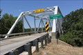 view gallery view galleryN21.2 km |  Colorado River Bridge -- US 190 at Lampasas/San Saba County Line, TX Colorado River Bridge -- US 190 at Lampasas/San Saba County Line, TX
in Truss Bridges Cantilevered Warren through truss bridge over the Colorado River between San Saba and Lampasas counties in TX posted by: Benchmark Blasterz location: Texas date approved: 10/13/2015 last visited: 04/14/2018 |
 view gallery view galleryNE21.7 km |  AT&SF Depot - Lometa, TX AT&SF Depot - Lometa, TX
in Train Stations/Depots Wood combination depot circa 1909 badly in need of restoration. It is being used by TDOT as a storage building. posted by:  WalksfarTX WalksfarTX location: Texas date approved: 04/18/2018 last visited: 06/12/2021 |
 view gallery view galleryNE21.9 km | Lometa School - Lometa, TX in WPA Projects The curved entrance with columns was added to the building in 1986 to hold the school bell from 1886. posted by: WalksfarTX location: Texas date approved: 06/14/2021 last visited: never |
 view gallery view galleryNE21.9 km |  Lometa School Bell - Lometa, TX Lometa School Bell - Lometa, TX
in Bell Towers The curved entrance with columns was added to the building in 1986 to hold the school bell from 1886. posted by: WalksfarTX location: Texas date approved: 06/12/2021 last visited: never |
 view gallery view gallery W22.4 km W22.4 km
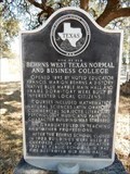
| Site of Old Behrns West Texas Normal and Business College in Texas Historical Markers A TX historical marker is in front of the former Cherokee Elementary School property that is now used as the High School. The address is 305 S. Indian Ave., Cherokee, TX 76832. posted by: WayBetterFinder location: Texas date approved: 12/18/2020 last visited: 12/18/2020 |
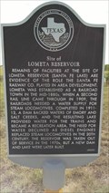 view gallery view galleryN22.7 km | Site of Lometa Reservoir in Texas Historical Markers A reservoir built as a water supply for steam locomotives, this is now used as a recreational area. posted by: WayBetterFinder location: Texas date approved: 09/22/2015 last visited: 09/27/2015 |
 view gallery view gallery NW23.7 km NW23.7 km
| Indian Signaling Grounds in Texas Historical Markers A state historic marker located at the US 190 rest area east of San Saba preserves the location of important Indian signaling ground posted by: Benchmark Blasterz location: Texas date approved: 01/16/2017 last visited: 06/12/2021 |
 view gallery view gallery SW23.7 km SW23.7 km
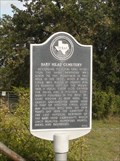
| Baby Head Cemetery in Texas Historical Markers The name "Babyhead" was given to the mountain in this area in the 1850s, when a small child was killed by Indians and its remains left on the mountain. A town and the cemetery were established in the vicinity in the 1870s. posted by: SoloSeekers ヅ location: Texas date approved: 10/27/2013 last visited: 02/07/2017 |
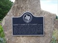 view gallery view galleryNW24.6 km | Barnett-Hamrick Settlement in Texas Historical Markers At Elevation 1,204.2 posted by: HotTater location: Texas date approved: 06/08/2009 last visited: 06/12/2021 |
|