 view gallery view gallery NE0.3 km NE0.3 km
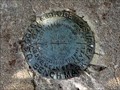
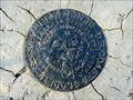
|   BN0042 - "M 119" bench mark disk - Kingsland, TX BN0042 - "M 119" bench mark disk - Kingsland, TX
in U.S. Benchmarks This benchmark is located by a railroad line near the old "Victorian House at the Antlers Hotel" establishment in Kingsland, Texas. posted by:  Raven Raven location: Texas date approved: 04/22/2015 last visited: 08/15/2014 |
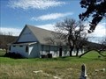
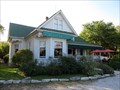 view gallery view galleryNE0.3 km |  Victorian House at The Antlers Hotel - Kingsland, Texas Victorian House at The Antlers Hotel - Kingsland, Texas
in Relocated Structures Originally built in 1909, this house was a residence in Round Rock, TX. It was used as a movie set for "The Texas Chainsaw Massacre", then ultimately relocated 50 miles west to Kingsland, TX to be converted into a café adjoining a resort area. posted by: Raven location: Texas date approved: 02/10/2015 last visited: 05/23/2020 |
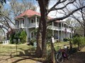 view gallery view galleryNE0.5 km |  Antlers Hotel - Austin and Northwestern Railroad Historic District--Fairland to Llano - Kingsland, TX Antlers Hotel - Austin and Northwestern Railroad Historic District--Fairland to Llano - Kingsland, TX
in NRHP Historic Districts - Contributing Buildings The boundaries extend beyond the right of way in Kingsland to include the Antlers Hotel and its associated buildings and structures built by the Southern Pacific Railroad in 1901. posted by:  WalksfarTX WalksfarTX location: Texas date approved: 03/13/2018 last visited: 06/18/2021 |
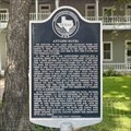 view gallery view galleryNE0.5 km |  Antlers Hotel Antlers Hotel
in Texas Historical Markers This post-mounted subject marker stands in front of the hotel itself, outside the fence, to the right of the gate on King Court Road in Kingsland. posted by: QuesterMark location: Texas date approved: 06/20/2021 last visited: 03/12/2018 |
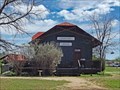 view gallery view galleryNE0.5 km |  San Antonio and Aransas Pass Depot - Kingsland, TX San Antonio and Aransas Pass Depot - Kingsland, TX
in Train Stations/Depots Muldoon (Fayette County) Depot circa 1890s relocated to Kingsland. It is now a gift shop/antique shop in Antler's Hotel Complex. It sits next to inactive tracks. posted by: WalksfarTX location: Texas date approved: 03/13/2018 last visited: never |
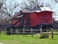 view gallery view galleryNE0.5 km |  McKinney Coach - Kingsland, TX McKinney Coach - Kingsland, TX
in Static Train Cars Parked next to the old RR depot. Part of the Antler's Inn complex, it has been remodeled into a place to stay. posted by: WalksfarTX location: Texas date approved: 03/12/2018 last visited: never |
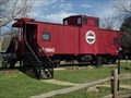
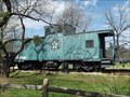 view gallery view galleryNE0.5 km |  Houston & Texas Central Caboose - Kingsland, TX Houston & Texas Central Caboose - Kingsland, TX
in Train Cabooses Green caboose with Houston & Texas Central logo on the side. NW 518693 is the number on the side. posted by: WalksfarTX location: Texas date approved: 03/15/2018 last visited: never |
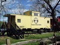 view gallery view galleryNE0.5 km | Southern Pacific & Texas and New Orleans Caboose - Kingsland, TX in Train Cabooses Yellow caboose with Southern Pacific Logo and the words Texas and New Orleans below it. NW 555097 is also on the caboose. posted by: WalksfarTX location: Texas date approved: 03/15/2018 last visited: never |
 view gallery view galleryNE0.5 km | Austin and Northwestern Caboose - Kingsland, TX in Train Cabooses Faded red caboose with Austin and Northwestern Railroad logo on the side. NW 518543 is the number on the side. posted by: WalksfarTX location: Texas date approved: 03/15/2018 last visited: never |
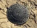
 view gallery view gallery E1 km E1 km
| BN0038 - "L 119" bench mark disk - Kingsland, TX in U.S. Benchmarks This benchmark is located at the northwest side of a railroad bridge crossing the Colorado river in Kingsland, Texas. posted by: Raven location: Texas date approved: 02/10/2015 last visited: 08/15/2014 |
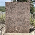 view gallery view gallery SE2.7 km SE2.7 km
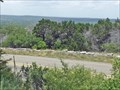
| Fisher - Miller Grant in Texas Historical Markers This granite block, set in concrete, is behind a fence at the overlook rest stop on Lookout Mountain on FM-1431 about a mile out of Kingsland. posted by: QuesterMark location: Texas date approved: 07/24/2021 last visited: 07/23/2021 |
 view gallery view gallerySE3.2 km | BN0037 - "K 119" bench mark disk - Kingsland, TX in U.S. Benchmarks This benchmark is located on a rock outcrop near FM 1431 and Caldwell Blvd (CR-127) about 2 miles southwest of Kingsland, Texas. posted by: Raven location: Texas date approved: 04/22/2015 last visited: 08/15/2014 |
 view gallery view galleryNE7.6 km |  Hoovers Valley Cemetery - Buchanan Dam, TX Hoovers Valley Cemetery - Buchanan Dam, TX
in Worldwide Cemeteries Settlement of the area began in the early 1850s. The community was named for the Hoover family, who bought a 640-acre homestead there in 1854. posted by: WalksfarTX location: Texas date approved: 03/11/2018 last visited: 09/06/2019 |
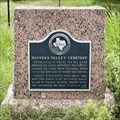 view gallery view galleryNE7.7 km | Hoover's Valley Cemetery in Texas Historical Markers This little subject marker is affixed to a short pink granite monument next to Park Road 4 where County Road 119 ends. The cemetery it commemorates is on the opposite side of PR 4 in Burnet. posted by: QuesterMark location: Texas date approved: 08/11/2021 last visited: 11/12/2021 |
 view gallery view galleryNE7.7 km |  Park Road 4 - Burnet, TX Park Road 4 - Burnet, TX
in Civilian Conservation Corps Civilian Conservation Corps Company No. 854 built this park road with overlook. posted by: WalksfarTX location: Texas date approved: 05/26/2020 last visited: never |
 view gallery view gallery N8.9 km N8.9 km
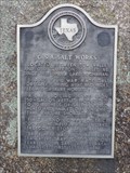
| C.S.A. Salt Works in Texas Historical Markers Texas Historical Marker commemorating the salt works that was once nearby -- now under Lake Buchanan -- and its use by Texas and the Confederacy during the Civil War. Located in a roadside park at the intersection of TX 29 and TX 261. posted by: QuarrellaDeVil location: Texas date approved: 04/28/2013 last visited: 05/17/2013 |
 view gallery view galleryE8.9 km |  Observation Tower - Longhorn Cavern State Park, TX Observation Tower - Longhorn Cavern State Park, TX
in Look-Out Towers This observation tower, built it 1935 by the Civilian Conservation Corps ("CCC"), offers a 360-degree view of the Texas Hill Country. posted by: Raven location: Texas date approved: 09/13/2014 last visited: 12/13/2021 |
 view gallery view galleryE8.9 km | Observation/Water Tower - Longhorn Cavern State Park, TX in Civilian Conservation Corps Built by CCC Company 854 in 1935, this observation/water tower was one of several improvement projects conducted within the Longhorn Cavern State Park in Texas during 1934-1940. posted by: Raven location: Texas date approved: 09/15/2014 last visited: 12/13/2021 |
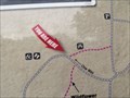 view gallery view galleryE8.9 km |  You are Here - Longhorn Cavern State Park - Burnet, TX You are Here - Longhorn Cavern State Park - Burnet, TX
in 'You Are Here' Maps Located along the Wildflower Trail. posted by: WalksfarTX location: Texas date approved: 12/13/2021 last visited: never |
 view gallery view gallery W9 km W9 km
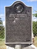
| Early Explorers in Llano County in Texas Historical Markers This post-mounted subject marker stands defiantly between two boulders in a little pull-out on SH71 15 miles east of Llano. posted by: QuesterMark location: Texas date approved: 10/25/2015 last visited: 10/10/2020 |
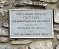 view gallery view galleryE9 km |  Longhorn Cavern State Park Administration Building - 1967 - Burnet, TX Longhorn Cavern State Park Administration Building - 1967 - Burnet, TX
in Dated Architectural Structures Multifarious Metal plaque on the building. posted by: WalksfarTX location: Texas date approved: 12/13/2021 last visited: never |
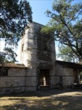
 view gallery view galleryE9 km |  Longhorn Cavern National Natural Landmark - Burnet, Texas Longhorn Cavern National Natural Landmark - Burnet, Texas
in U.S. National Natural Landmarks Longhorn Cavern State Park, 11 miles southwest of Burnet in Burnet County. posted by: txoilgas location: Texas date approved: 03/09/2009 last visited: 12/13/2021 |
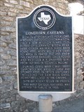 view gallery view galleryE9 km | Longhorn Caverns in Texas Historical Markers The entrance of a very intersting cavern. posted by: txoilgas location: Texas date approved: 02/22/2009 last visited: 12/13/2021 |
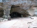 view gallery view galleryE9 km | Longhorn Cavern - Burnet, Texas in Civilian Conservation Corps The Civilian Conservation Corps (CCC) began work at Longhorn Cavern in the 1930s, many of the cavern's chambers were filled with dozens of feet of silt and debris. posted by: txoilgas location: Texas date approved: 02/01/2009 last visited: 03/27/2019 |
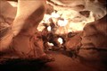 view gallery view galleryE9 km |  Longhorn Cavern State Park - Burnet, Texas Longhorn Cavern State Park - Burnet, Texas
in State/Provincial Parks Our earliest records indicate that the Comanche Indians were the first to use the cavern. They came in about 400 years or so before anyone else did.
posted by: txoilgas location: Texas date approved: 01/30/2009 last visited: 12/13/2021 |
|