 view gallery view gallery NW6.6 km NW6.6 km
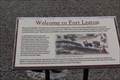
|   Chihuahua San-Antonio Road -- Fort Leaton SHS, Presidio County TX Chihuahua San-Antonio Road -- Fort Leaton SHS, Presidio County TX
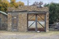
in Wagon Roads and Trails The Fort Leaton State Historic Site is located along the Chihuahua-San Antonio Road, a branch of the Chihuahua Trail, an important trade route between the US and Mexico posted by:  Benchmark Blasterz Benchmark Blasterz location: Texas date approved: 02/04/2017 last visited: 12/23/2016 |
 view gallery view gallery SE9 km SE9 km
|  Hacienda Gate No1 - Redford, Texas. Hacienda Gate No1 - Redford, Texas.
in Gates of Distinction The gate is located on Texas Highway 170 about 15-miles south of Presidio, Texas. posted by:  misfitt misfitt location: Texas date approved: 12/08/2008 last visited: 11/06/2011 |
 view gallery view gallerySE9 km | Hacienda Gate No 2 - Redford, Texas. in Gates of Distinction The gate is located on Texas Highway 170 about 15-miles south of Presidio, Texas. posted by: misfitt location: Texas date approved: 12/08/2008 last visited: 11/06/2011 |
 view gallery view galleryNW11.6 km |  LONGEST -- Enemy Occupation in Confederate Texas, Presidio TX LONGEST -- Enemy Occupation in Confederate Texas, Presidio TX
in Superlatives The occupation of the Davis Mountains by Federal troops during the Civil War was the longest occupation by enemy troops in Texas history posted by: Benchmark Blasterz location: Texas date approved: 01/24/2017 last visited: 12/23/2016 |
 view gallery view galleryNW11.6 km |  FIRST -- Mail Service from San Antonio to El Paso, Presidio TX FIRST -- Mail Service from San Antonio to El Paso, Presidio TX
in First of its Kind The state historic marker for Captain Henry Skillman at St Francis Plaza in downtown Presidio TX details how he opened mail service between San Antonio and El Paso in 1851 posted by: Benchmark Blasterz location: Texas date approved: 01/28/2017 last visited: 12/24/2016 |
 view gallery view galleryNW11.6 km | FIRST -- Butterfield Overland Mail Coach from Horsehead Crossing to El Paso, Presidio TX in First of its Kind The state historic marker for Captain Henry Skillman at St Francis Plaza in downtown Presidio TX details how he blazed as new trail for the Butterfield Overland Mail through Comanche territory in 1858 posted by: Benchmark Blasterz location: Texas date approved: 01/28/2017 last visited: 12/24/2016 |
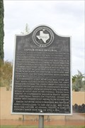 view gallery view galleryNW11.6 km |  Captain Henry Skillman, C.S.A. Captain Henry Skillman, C.S.A.
in Texas Historical Markers The state historic marker for Captain Henry Skillman at St Francis Plaza in downtown Presidio TX posted by: Benchmark Blasterz location: Texas date approved: 01/24/2017 last visited: 12/23/2016 |
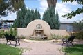 view gallery view galleryNW11.6 km |  St Francis Plaza Fountains - Presidio, Texas. St Francis Plaza Fountains - Presidio, Texas.
in Fountains These fountains are located in the small St Francis Plaza on O’Reilly St\ US-67 at Tremont St. in Presidio, Texas. posted by: misfitt location: Texas date approved: 08/23/2008 last visited: 12/23/2016 |
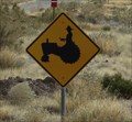 view gallery view galleryNW11.6 km |  Tractor Crossing -- Presidio TX Tractor Crossing -- Presidio TX
in Uncommon Crossing Signs Burro Crossing we expected. TRACTOR? No so much! posted by: Benchmark Blasterz location: Texas date approved: 01/24/2017 last visited: 12/23/2016 |
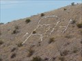 view gallery view galleryNW13 km |  SR 13 -- US 67 N of Presidio TX SR 13 -- US 67 N of Presidio TX
in Letters on Hills A group of people have placed letters on a small rise outside of Presidio to say SR 13 posted by: Benchmark Blasterz location: Texas date approved: 01/24/2017 last visited: 12/23/2016 |
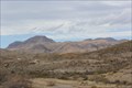
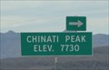 view gallery view gallery N30.7 km N30.7 km
|  Elev. 7730 - Chinati Peak - US 67 N of Presidio Elev. 7730 - Chinati Peak - US 67 N of Presidio
in Elevation Signs The elevation sign for Chinati Preak, a landmark along the US 67 north of Presidio posted by: Benchmark Blasterz location: Texas date approved: 01/24/2017 last visited: 12/23/2016 |
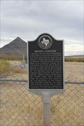 view gallery view galleryN33.5 km | Brooks Cemetery in Texas Historical Markers The historic marker or Brooks Cemetery in the ghost town of Shafter TX posted by: Benchmark Blasterz location: Texas date approved: 01/28/2017 last visited: 12/23/2016 |
 view gallery view galleryN33.5 km |  Brooks Cemetery -- Shafter TX Brooks Cemetery -- Shafter TX
in Worldwide Cemeteries The Brooks Cemetery in the ghost towm of Shafter Texas posted by: Benchmark Blasterz location: Texas date approved: 01/24/2017 last visited: 12/23/2016 |
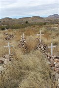 view gallery view galleryN33.5 km | Concordia Cemetery -- Shafter TX in Worldwide Cemeteries Concordia Cemetery in Shafter -- West Texas is often segregated in life and in death, but this time not as you might first suspect posted by: Benchmark Blasterz location: Texas date approved: 01/24/2017 last visited: 12/23/2016 |
 view gallery view gallerySE33.6 km |  Panther Canyon Abode Big Bend Ranch State Park - Texas Panther Canyon Abode Big Bend Ranch State Park - Texas
in Remote Backcountry Shelters The shelter is located along the Rancherias Trail about 6 miles from the East Rancherias trailhead which is 1n the Big Bend Ranch State Park. posted by: txoilgas location: Texas date approved: 01/27/2009 last visited: 10/14/2009 |
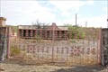
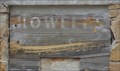 view gallery view galleryN34 km |  Howell's General Store -- Shafter TX Howell's General Store -- Shafter TX
in Ghost Signs The ghost sign is all that remains of Howell's General Store in the silver mining ghost town of Shafter posted by: Benchmark Blasterz location: Texas date approved: 02/04/2017 last visited: 12/23/2016 |
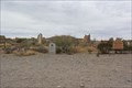
 view gallery view galleryN34 km |  Shafter TX Shafter TX
in Ghost Towns Shafter Texas got its start with silver mining, but died after the mines struggled and military bases in nearby Marfa closed posted by: Benchmark Blasterz location: Texas date approved: 02/08/2017 last visited: 12/27/2016 |
 view gallery view galleryN34 km |  Shafter - Shafter TX Shafter - Shafter TX
in American Guide Series In 1940, Shafter was a busy mining town. Ten years after the WPA visited, it was a ghost. posted by: Benchmark Blasterz location: Texas date approved: 02/12/2017 last visited: 12/27/2016 |
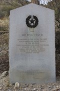
 view gallery view galleryN34 km | Milton Faver in Texas Historical Markers The grey granite 1936 Centennial marker for Milton Faver at Shafter Texas posted by: Benchmark Blasterz location: Texas date approved: 01/27/2017 last visited: 12/23/2016 |
 view gallery view galleryN34 km | FIRST -- Anglo-American Ranch in the Big Bend, Shafter TX in First of its Kind When Milton Faver established his ranch in Shafter in the 1850s, it was the first Anglo ranch in the Big Bend area of Texas posted by: Benchmark Blasterz location: Texas date approved: 01/26/2017 last visited: 12/23/2016 |
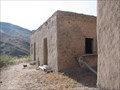
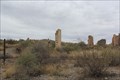
 view gallery view galleryN34 km |  Shafter Historic Mining District -- Shafter TX Shafter Historic Mining District -- Shafter TX
in U.S. National Register of Historic Places The silver-mining ghost town of Shafter is listed in the US National Register of Historic Places as the Shafter Historic Mining District posted by: Benchmark Blasterz location: Texas date approved: 01/30/2017 last visited: 12/25/2016 |
 view gallery view galleryN34 km |  American Metal Company Mines -- Shafter TX American Metal Company Mines -- Shafter TX
in Mines Silver ore was discovered in Shafter in 1880, but the mines were never able to operate consistenty or profitably posted by: Benchmark Blasterz location: Texas date approved: 01/25/2017 last visited: 12/23/2016 |
 view gallery view galleryN34.1 km |  Sagrado Corazon de Jesus (Sacred Heart) Catholic Church -- Shafter TX Sagrado Corazon de Jesus (Sacred Heart) Catholic Church -- Shafter TX
in Roadside Attractions he 1970 Sci Fi classic Andromeda Strain was filmed outside this historic church in Shafter posted by: Benchmark Blasterz location: Texas date approved: 01/26/2017 last visited: 12/23/2016 |
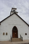 view gallery view galleryN34.1 km |  Sagrado Corazon de Jesus (Sacred Heart) Catholic Church - Shafter Mining Historic District -- Shafter TX Sagrado Corazon de Jesus (Sacred Heart) Catholic Church - Shafter Mining Historic District -- Shafter TX
in NRHP Historic Districts - Contributing Buildings Sagrado Corazon de Jesus (Sacred Heart) Catholic Church is a contributing builing to the US National Register Shafter Mining Historic District in Shafter TX posted by: Benchmark Blasterz location: Texas date approved: 01/24/2017 last visited: 12/23/2016 |
 view gallery view galleryN34.1 km |  Sagrado Corazon de Jesus (Sacred Heart) Catholic Mission Church -- Shafter TX Sagrado Corazon de Jesus (Sacred Heart) Catholic Mission Church -- Shafter TX
in Roman Catholic Churches Sagrado Corazon de Jesus (Sacred Heart) Catholic Church has served the Catholic faithful in this desolate and rugged area since 1890 posted by: Benchmark Blasterz location: Texas date approved: 01/25/2017 last visited: 12/23/2016 |
|