 view gallery view gallery E0.3 km E0.3 km
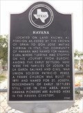
|   Havana Havana
in Texas Historical Markers This Texas Historical Marker is at the Havana Cemetery on Hwy 83, 550 feet east of Patricio Perez Road in the community of Havana, Texas. posted by:  PeterNoG PeterNoG location: Texas date approved: 03/04/2014 last visited: 07/18/2015 |
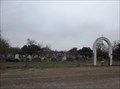
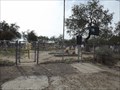 view gallery view galleryE0.3 km |  Havana Cemetery - Havana TX Havana Cemetery - Havana TX
in Worldwide Cemeteries This Cemetery is on the south side of US Hwy 83, 550 feet east of Patricia Perez Road in the community of Havana in Hidalgo County, Texas. posted by: PeterNoG location: Texas date approved: 02/22/2014 last visited: 07/18/2015 |
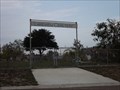
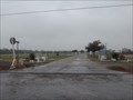
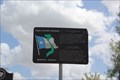 view gallery view galleryE0.3 km |  Vietnam War Memorial -- US 83 at Havana Cemetery, Havana TX USA Vietnam War Memorial -- US 83 at Havana Cemetery, Havana TX USA
in Vietnam War Memorials One of many markers of this type along US 83, which has been designated the Texas Vietnam War Memorial Highway. posted by: Benchmark Blasterz location: Texas date approved: 08/19/2015 last visited: 08/20/2015 |
 view gallery view gallery NW1.9 km NW1.9 km
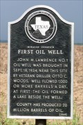
| Hidalgo County's First Oil Well in Texas Historical Markers Near this site was Hidalgo County's first oil well. posted by:  JimmyEv JimmyEv location: Texas date approved: 11/30/2007 last visited: 07/18/2015 |
 view gallery view galleryE2.9 km | Lakeview Cemetery - La Joya TX in Worldwide Cemeteries This Cemetery is on West 6th Street, 400 feet west of King Street in La Joya, Texas. posted by: PeterNoG location: Texas date approved: 04/04/2014 last visited: 01/12/2014 |
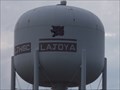
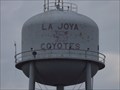 view gallery view galleryE2.9 km |  Coyotes Water Tower - La Joya TX Coyotes Water Tower - La Joya TX
in Water Towers This Water Tower is 400 feet north of US Hwy 83 Expressway just west of the Nellie Schunior Elementary School in La Joya, Texas. posted by: PeterNoG location: Texas date approved: 05/06/2014 last visited: 07/18/2015 |
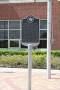 view gallery view galleryE3.1 km |  FIRST -- Superintendent of Chapin Schools, La Joya TX FIRST -- Superintendent of Chapin Schools, La Joya TX
in First of its Kind Nellie L. Schunior was named the first superintendent of Chapin school. Chapin was later renamed Edinburg. posted by: Benchmark Blasterz location: Texas date approved: 08/19/2015 last visited: 07/18/2015 |
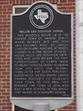 view gallery view galleryE3.1 km | Nellie Leo Schunior School in Texas Historical Markers This Texas Historical Marker is in front of the Nellie Leo Schunior School (now La Joya Independent School District offices) on US 83 Expressway just west of FM 2521 (Leo Avenue) in La Joya, Texas. posted by: PeterNoG location: Texas date approved: 03/04/2014 last visited: 07/18/2015 |
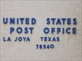 view gallery view galleryE3.2 km |  La Joya TX 78560 La Joya TX 78560
in U.S. Post Offices This Post Office is on FM 3521, 300 feet north of US Hwy 83 in La Joya, Texas. posted by: PeterNoG location: Texas date approved: 05/04/2014 last visited: 01/12/2014 |
 view gallery view galleryE4 km |  Rancho El Charco Rancho El Charco
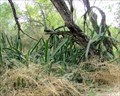
in Nature Centers This 150 acre wildlife park, with a bordering 75 acre lake, is one of the last patches of brush country remaining in the lower Rio Grande Valley in southern Texas. posted by: capbat location: Texas date approved: 02/13/2007 last visited: 02/06/2014 |
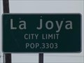 view gallery view galleryE5 km |  La Joya TX - Pop. 3,303 La Joya TX - Pop. 3,303
in Population Signs This Population Sign is on US 83 Expressway, 1500 feet east of North Tabsco Road, near the water tower on the east side of La Joya, Texas. posted by: PeterNoG location: Texas date approved: 03/05/2014 last visited: 07/18/2015 |
 view gallery view galleryE5 km | Water Tower - La Joya TX in Water Towers This Water Tower is 400 feet north of US Hwy 83 Expessway about 1/4 mile east of North Tabasco Road on the east side of La Joya, Texas. posted by: PeterNoG location: Texas date approved: 05/06/2014 last visited: 07/18/2015 |
 view gallery view gallery W5.3 km W5.3 km
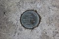
|  IBWC-CIDLA benchmark disk -- Los Ebanos TX IBWC-CIDLA benchmark disk -- Los Ebanos TX
in U.S. Benchmarks A joint US International Boundary and Water Commission - MX Comision Internacional des Limites Y Aguas benchmark disk on a concrete pad with a historic marker near the Los Ebanos ferry crossing to Mexico posted by: Benchmark Blasterz location: Texas date approved: 08/19/2015 last visited: 08/20/2015 |
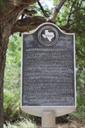
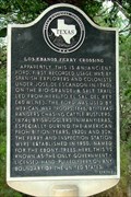 view gallery view galleryW5.3 km | Los Ebanos Ferry Crossing in Texas Historical Markers This ferry crossing has been used to ford the Rio Grande since ancient times. Today you can take the hand-pulled ferry across the river. posted by: JimmyEv location: Texas date approved: 11/29/2007 last visited: 07/18/2015 |
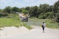 view gallery view galleryW5.5 km |  Los Ebanos Ferry -- Los Ebanos TX - Ciudad Gustavo Diaz Ordaz, Tamps., MX Los Ebanos Ferry -- Los Ebanos TX - Ciudad Gustavo Diaz Ordaz, Tamps., MX
in Ferries and Ferry Landings The border crossing between Los Ebanos and Cd. Ordaz is made by means of a hand-pulled ferry posted by: Benchmark Blasterz location: Texas date approved: 08/20/2015 last visited: 07/18/2015 |
 view gallery view galleryW5.5 km |  Los Ebanos TX - Ciudad Gustavo Diaz Ordaz, Tamps., MX Los Ebanos TX - Ciudad Gustavo Diaz Ordaz, Tamps., MX
in Border Crossings The border crossing between Los Ebanos and Cd. Ordaz is made by means of a hand-pulled ferry posted by: Benchmark Blasterz location: Texas date approved: 08/19/2015 last visited: 08/20/2015 |
 view gallery view galleryW5.5 km |  ONLY -- Hand Pulled International Ferry in US -- Los Ebanos TX-Cd. Diaz Ordaz MX ONLY -- Hand Pulled International Ferry in US -- Los Ebanos TX-Cd. Diaz Ordaz MX
in Superlatives The international ferry between Los Ebanos TX and Cd. Diaz Ordaz MX is the only hand-pulled ferry of its kind in the United States posted by: Benchmark Blasterz location: Texas date approved: 08/20/2015 last visited: 07/18/2015 |
 view gallery view galleryW5.5 km |  LAST -- Hand Pulled International Ferry in US -- Los Ebanos TX-Cd. Diaz Ordaz MX LAST -- Hand Pulled International Ferry in US -- Los Ebanos TX-Cd. Diaz Ordaz MX
in Last of its Kind The international ferry between Los Ebanos TX and Cd. Diaz Ordaz MX is the last (and only) hand-pulled ferry of its kind in the United States posted by: Benchmark Blasterz location: Texas date approved: 08/19/2015 last visited: 07/18/2015 |
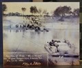 view gallery view galleryW5.5 km |  1950 & 2015 -- Los Ebanos Ferry, Los Ebanos TX - Ciudad Gustavo Diaz Ordaz, Tamps., MX 1950 & 2015 -- Los Ebanos Ferry, Los Ebanos TX - Ciudad Gustavo Diaz Ordaz, Tamps., MX
in Photos Then and Now The natural ford over the Rio Grande here has been used for centuries. A hand-pulled ferry began operation in 1950, and is still carrying cars and passengers today (2015) posted by: Benchmark Blasterz location: Texas date approved: 08/20/2015 last visited: 07/18/2015 |
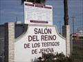 view gallery view galleryE6.6 km |  Salón del Reino de Los Testigos de Jehová - Penitas TX Salón del Reino de Los Testigos de Jehová - Penitas TX
in Kingdom Halls of Jehovah's Witnesses This Salón del Reino de Los Testigos de Jehová (Kingdom Hall of Jehovah's Witnesses) is on Tom Gull Road at Diamond Avenue, about 1/4 north of the US 83 Expressway in Penitas, Texas. posted by: PeterNoG location: Texas date approved: 02/26/2014 last visited: 12/24/2013 |
 view gallery view galleryE7.1 km | Penitas Cemetery - Penitas TX in Worldwide Cemeteries This Cemetery is on an un-named laneway on the north side of the Military Road (FM 1427), 140 feet east of Zamora Road in Penitas, Texas. posted by: PeterNoG location: Texas date approved: 04/18/2014 last visited: 02/06/2014 |
 view gallery view gallery SE11.3 km SE11.3 km
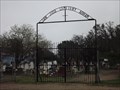
| San Jose Cemetery - Abram TX in Worldwide Cemeteries This Cemetery is on Cemetery Road, 1000 feet north of West Military Road in the community of Abram in Hidalgo County, Texas. posted by: PeterNoG location: Texas date approved: 04/18/2014 last visited: 02/06/2014 |
 view gallery view gallerySE11.6 km | Garden of Angels Cemetery - Abram TX in Worldwide Cemeteries This Cemetery is on Abram Road (FM 1427), 1.5 miles south of US Business 83 in Abram, Texas. posted by: PeterNoG location: Texas date approved: 04/21/2014 last visited: 02/06/2014 |
 view gallery view galleryE14.3 km |  Mission, Texas - Guatemala City, Guatemala, site 1 Mission, Texas - Guatemala City, Guatemala, site 1
in International Space Station Sightings Hardyp3 and ElCaballero sighted the ISS during one pass on the evening of October 30, 2013 in Mission Texas, and Guatemala City, Guatemala respectively. posted by: DrHayJude location: Texas date approved: 10/31/2013 last visited: never |
 view gallery view gallerySE14.6 km |  Bentsen-Rio Grande Valley State Park - Mission, Texas Bentsen-Rio Grande Valley State Park - Mission, Texas
in State/Provincial Parks In the chapparal along the banks of the Rio Grande River is one of only two state parks in the Valley. It used to be crowded with families, but now caters almost exclusively to birders and hikers. posted by: JimmyEv location: Texas date approved: 05/05/2008 last visited: 02/08/2018 |
|