 view gallery view gallery W6.6 km W6.6 km
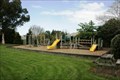
|   Stirling Playground — Balclutha, New Zealand Stirling Playground — Balclutha, New Zealand
in Public Playgrounds This quiet neighbourhood playground is worth travelling the 2.4 km from SH 1 to visit. posted by:  Dunbar Loop Dunbar Loop location: South Island, New Zealand date approved: 11/06/2009 last visited: 08/06/2012 |
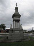 view gallery view galleryW9.8 km |  Balclutha Combined War Memorial - Balclutha, New Zealand Balclutha Combined War Memorial - Balclutha, New Zealand
in World War I Memorials and Monuments War memorial initially placed to honor fallen of the Great War with the fallen of World War II added later located in Balclutha, New Zealand. posted by:  BruceS BruceS location: South Island, New Zealand date approved: 02/01/2013 last visited: 12/13/2014 |
 view gallery view galleryW9.8 km |  Carnegie Library — Balclutha, New Zealand Carnegie Library — Balclutha, New Zealand
in Carnegie Library Buildings Built in 1913 the Carnegie Library, today the Balclutha Branch of the Clutha District Library System, is one of two original Carnegie Libraries that operate as borrowing libraries today. posted by: Dunbar Loop location: South Island, New Zealand date approved: 11/06/2009 last visited: 08/08/2013 |
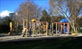 view gallery view galleryW10.5 km | Naith Park Playground — Balclutha, New Zealand in Public Playgrounds A nice playground in a quiet park. posted by: Dunbar Loop location: South Island, New Zealand date approved: 08/24/2009 last visited: 07/15/2012 |
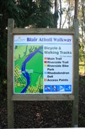 view gallery view galleryW10.6 km |  Blair Atholl Walkway — Naith Park access point Blair Atholl Walkway — Naith Park access point
in Hiking and walking trailheads The Blair Atholl Walkway runs along the stopbanks of the Clutha River at Balclutha. posted by: Dunbar Loop location: South Island, New Zealand date approved: 08/23/2009 last visited: never |
 view gallery view galleryW11.6 km |  Balclutha Otago. New Zealand. Balclutha Otago. New Zealand.
in Welcome Signs Welcome to Balclutha - "Big River Town". posted by:  Punga and Paua Punga and Paua location: South Island, New Zealand date approved: 12/20/2009 last visited: 06/25/2012 |
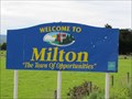 view gallery view gallery NE14.5 km NE14.5 km
| Milton, New Zealand in Welcome Signs Welcome sign of the town of Milton "The Town of Opportunities" in south east of the South Island, New Zealand. posted by: BruceS location: South Island, New Zealand date approved: 02/02/2013 last visited: never |
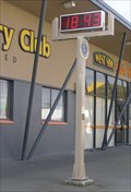 view gallery view galleryNE15.9 km |  Milton Time and Temp Sign. Milton. New Zealand. Milton Time and Temp Sign. Milton. New Zealand.
in Time and Temperature Signs A Time and Temperature Sign in the main street of the South Island town of Milton. posted by: Punga and Paua location: South Island, New Zealand date approved: 12/02/2009 last visited: 08/07/2013 |
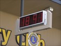 view gallery view galleryNE15.9 km |  Lions Club Clock - Milton. South Is. New Zealand. Lions Club Clock - Milton. South Is. New Zealand.
in Lions Clubs International Markers A Lions Club Marker above an electronic clock/temperature which has been gifted to the Milton District by the Lions Club of Milton. There is a brass plaque as well as the usual LIONS L INTERNATIONAL marker sign. posted by: Punga and Paua location: North Island, New Zealand date approved: 11/15/2010 last visited: 01/07/2013 |
 view gallery view galleryNE16.3 km | Bruce Fallen Soldier Memorial - Milton, New Zealand in World War I Memorials and Monuments War memorial placed in the former Bruce district in Milton to honor the fallen of World War I, additional inscriptions were added for World War II. posted by: BruceS location: South Island, New Zealand date approved: 02/02/2013 last visited: 12/13/2014 |
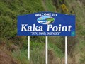 view gallery view gallery SW17.1 km SW17.1 km
| Kaka Point - New Zealand in Welcome Signs Welcome sign for the small community of Kaka Point, South Island, New Zealand. posted by: BruceS location: South Island, New Zealand date approved: 01/30/2013 last visited: 08/08/2013 |
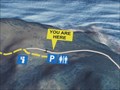 view gallery view gallery S22.2 km S22.2 km
|  Nugget Point Car Park You Are Here Map - New Zealand Nugget Point Car Park You Are Here Map - New Zealand
in 'You Are Here' Maps You area here map located at the car park for Nugget Point. posted by: BruceS location: South Island, New Zealand date approved: 01/29/2013 last visited: 11/27/2016 |
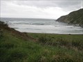 view gallery view galleryS22.2 km |  Roaring Bay - New Zealand Roaring Bay - New Zealand
in Wavy Places Bay located along the southeast coast of the South Island, New Zealand with large waves. posted by: BruceS location: South Island, New Zealand date approved: 01/29/2013 last visited: 11/27/2016 |
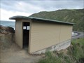 view gallery view galleryS22.2 km |  Roaring Bay Yellow Penguin Eyed View Blind - New Zealand Roaring Bay Yellow Penguin Eyed View Blind - New Zealand
in Birdwatching Locations Blind located along road to Nugget Point on the southeast coast of the South Island, New Zealand. posted by: BruceS location: South Island, New Zealand date approved: 02/02/2013 last visited: 11/27/2016 |
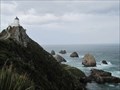 view gallery view galleryS22.4 km |  Nugget Point - South Island, New Zealand Nugget Point - South Island, New Zealand
in Wikipedia Entries Picturesque landform along the Otago coast on the South Island of New Zealand. posted by: BruceS location: South Island, New Zealand date approved: 12/22/2012 last visited: 11/27/2016 |
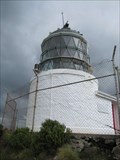
 view gallery view galleryS22.4 km |  Nugget Point Lighthouse - New Zealand Nugget Point Lighthouse - New Zealand
in Coastal Lighthouses Historic lighthouse in the Otago region on the South Island in New Zealand. posted by: BruceS location: South Island, New Zealand date approved: 12/23/2012 last visited: 11/27/2016 |
 view gallery view galleryS22.4 km | Nugget Point Lighthouse - New Zealand in Wikipedia Entries Historic lighthouse in the Otago region on the South Island in New Zealand. posted by: BruceS location: South Island, New Zealand date approved: 12/21/2012 last visited: 11/27/2016 |
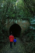 view gallery view gallerySW22.9 km |  Tunnel Hill — Owaka, New Zealand Tunnel Hill — Owaka, New Zealand
in Abandoned Train Tunnels Often claimed to be the southernmost railway tunnel in the world. posted by: Dunbar Loop location: South Island, New Zealand date approved: 08/23/2009 last visited: never |
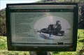 view gallery view gallerySW23 km |  Tunnel Hill — Owaka, New Zealand Tunnel Hill — Owaka, New Zealand
in Signs of History A series of signs explaining the significance and history of the tunnel on the Catlins River Branch of the NZ Railway network. posted by: Dunbar Loop location: South Island, New Zealand date approved: 08/24/2009 last visited: 06/24/2012 |
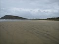 view gallery view galleryS25.4 km |  Cannibal Bay Beach - Owaka, New Zealand Cannibal Bay Beach - Owaka, New Zealand
in Beaches Beach located east of Owaka, New Zealand. posted by: BruceS location: South Island, New Zealand date approved: 01/30/2013 last visited: never |
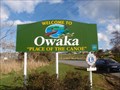 view gallery view gallerySW27 km | Owaka — Place of the Canoe in Welcome Signs Owaka — Place of the Canoe posted by: Dunbar Loop location: South Island, New Zealand date approved: 08/23/2009 last visited: 12/10/2014 |
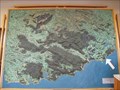 view gallery view gallerySW27.2 km |  Catlins Locality Map - Owaka Museum - Owaka, New Zealand Catlins Locality Map - Owaka Museum - Owaka, New Zealand
in 3D Map Models of Our World and Beyond 3d map of the Catlins area of southeast New Zealand at the Owaka Museum. posted by: BruceS location: South Island, New Zealand date approved: 01/29/2013 last visited: never |
 view gallery view gallerySW27.2 km |  Owaka Branch — Clutha District Libraries Owaka Branch — Clutha District Libraries
in Libraries A small rural library branch that also is in the same building as the local museum and tourist centre. posted by: Dunbar Loop location: South Island, New Zealand date approved: 08/23/2009 last visited: 04/18/2015 |
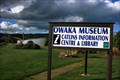 view gallery view gallerySW27.2 km |  Owaka Museum | Wahi Kahuika - The Meeting Place Owaka Museum | Wahi Kahuika - The Meeting Place
in History Museums Covering 200 years of history in the Catlins, this museum has a wide range of topics starting from the days Maori-European contact. posted by: Dunbar Loop location: South Island, New Zealand date approved: 08/23/2009 last visited: 04/18/2015 |
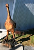 view gallery view gallerySW27.2 km |  Moa — Owaka, New Zealand Moa — Owaka, New Zealand
in Outside Wooden Display Carvings This moa is outside of the Owaka Museum. posted by: Dunbar Loop location: South Island, New Zealand date approved: 08/24/2009 last visited: 04/18/2015 |
|