 view gallery view gallery E15.9 km E15.9 km
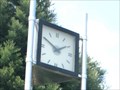
|   Centennial Clock — Palmerston, New Zealand Centennial Clock — Palmerston, New Zealand
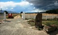
in Town Clocks Erected in 1982 to commemorate the 100th anniversary of Waihemo County, this clock is at the main junction of state highways 1 & 85. posted by:  Dunbar Loop Dunbar Loop location: South Island, New Zealand date approved: 11/22/2009 last visited: never |
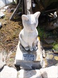 view gallery view galleryE15.9 km |  Chippie the Town Cat — Palmerston, New Zealand Chippie the Town Cat — Palmerston, New Zealand
in Animal Memorials Chippie was Palmerston's town cat from 1985 until 2000. posted by: Dunbar Loop location: South Island, New Zealand date approved: 11/24/2009 last visited: never |
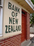
 view gallery view galleryE15.9 km |  Bank of New Zealand — Palmerston, New Zealand Bank of New Zealand — Palmerston, New Zealand
in Converted Bank Buildings The Bank of New Zealand has been converted into a designer fashion clothing shop. posted by: Dunbar Loop location: South Island, New Zealand date approved: 03/09/2010 last visited: 11/22/2012 |
 view gallery view galleryE15.9 km |  "Puketapu Radio Caroline AM 756" — Palmerston, New Zealand "Puketapu Radio Caroline AM 756" — Palmerston, New Zealand
in A.M./F.M. Radio Broadcasting Stations Puketapu Radio Caroline AM 756 has been on air since 1999 gradually increasing its wattage to 1000 watts. It can be heard throughout East Otago featuring country and easy listen music styles. Tune in on the Internet as well! posted by: Dunbar Loop location: South Island, New Zealand date approved: 11/26/2009 last visited: never |
 view gallery view galleryE15.9 km | Waihemo Pharmacy Clock — Palmerston, New Zealand in Town Clocks Located on the main highway of the South Island, this clock no longer works but still looks down at the passing traffic. posted by: Dunbar Loop location: South Island, New Zealand date approved: 11/22/2009 last visited: 11/22/2012 |
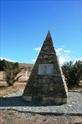
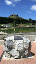 view gallery view galleryE16.1 km |  Sir John McKenzie — Palmerston, New Zealand Sir John McKenzie — Palmerston, New Zealand
in Citizen Memorials To make the McKenzie Cairn more accessible to people unwilling to climb the steep hillside the business community in Palmerston created this memorial to Sir John McKenzie and placed in the centre of town. posted by: Dunbar Loop location: South Island, New Zealand date approved: 03/09/2010 last visited: 11/22/2012 |
 view gallery view gallery SE20.1 km SE20.1 km
|  Wooden Horse Mailbox. Waikouaiti. Otago. New Zealand. Wooden Horse Mailbox. Waikouaiti. Otago. New Zealand.
in Themed Homemade Mailboxes A brown and white wooden horse greets the mailman in Beach Road, Waikouaiti. The mailbox has been cleverly handcrafted into a horse. posted by:  Punga and Paua Punga and Paua location: South Island, New Zealand date approved: 12/03/2009 last visited: 04/28/2013 |
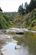
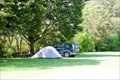 view gallery view galleryE21.2 km |  Trotters Gorge Scenic Reserve — Otago, New Zealand Trotters Gorge Scenic Reserve — Otago, New Zealand
in Campgrounds A scenic location with easy walking tracks for camping. Worth even stopping for a break on the journey between Christchurch and Dunedin. It is only 5 km off of State Highway 1. posted by: Dunbar Loop location: South Island, New Zealand date approved: 11/25/2009 last visited: 11/15/2010 |
 view gallery view gallery NW24.3 km NW24.3 km
|  Hyde Railway Disaster — Hyde, New Zealand Hyde Railway Disaster — Hyde, New Zealand
in Railway Disaster Sites "It is safe to say that no previous railway accident in this country has resulted in such a mass of distorted and wrecked rolling stock." -- Board of Inquiry. posted by: Dunbar Loop location: South Island, New Zealand date approved: 04/08/2010 last visited: never |
 view gallery view galleryNW24.5 km |  Hyde Railway Disaster — Hyde, New Zealand Hyde Railway Disaster — Hyde, New Zealand
in Disaster Memorials On June 4th, 1943 a train coming downhill from Hyde derailed killing 21 people and injuring 47. The accident was due to the engineer being intoxicated. posted by: Dunbar Loop location: South Island, New Zealand date approved: 03/28/2010 last visited: 11/16/2014 |
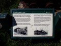
 view gallery view galleryE24.6 km |  Shag Point Coal Mine — Shag Point, New Zealand Shag Point Coal Mine — Shag Point, New Zealand
in Mines The Shag Point Coal Mine began operation in 1863 when D. Hutchinson started commercial extractions. It continued operating until the 1970s producing some 400,000 tonnes of coal. posted by: Dunbar Loop location: South Island, New Zealand date approved: 03/11/2010 last visited: never |
 view gallery view galleryE24.6 km |  Undersea Coal — Shag Point, New Zealand Undersea Coal — Shag Point, New Zealand
in Signs of History The coal seams at Shag Point produced a coal mining industry that operated for over 100 years and yielded some 400,000 tonnes of coal. posted by: Dunbar Loop location: South Island, New Zealand date approved: 03/09/2010 last visited: never |
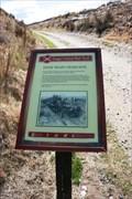
 view gallery view galleryE24.6 km |  Shag Point/Matakaea - near Palmerston, New Zealand Shag Point/Matakaea - near Palmerston, New Zealand
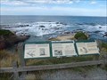
in Maori Historic Sites Shag Point/Matakaea is located about 9 km north of Palmerston. The site has significant cultural significance for Ngai Tahu. The posted coordinates are for the information signs. posted by: Marine Biologist location: South Island, New Zealand date approved: 03/04/2020 last visited: 03/19/2021 |
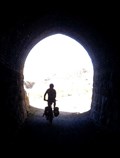 view gallery view galleryNW26.4 km |  No. 11 Tunnel — Otago Central Branch Line, New Zealand No. 11 Tunnel — Otago Central Branch Line, New Zealand
in Abandoned Train Tunnels No. 11 Tunnel is also known as Prices Creek, Hyde, Tiroiti, and Capburn. posted by: Dunbar Loop location: South Island, New Zealand date approved: 03/28/2010 last visited: never |
 view gallery view gallery S26.4 km S26.4 km
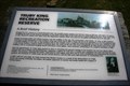
| Truby King Recreation Reserve — Seacliff, New Zealand in Signs of History A history of the Seacliff Lunatic Asylum and Sir Truby King's involvement posted by: Dunbar Loop location: New Zealand date approved: 12/05/2009 last visited: never |
 view gallery view gallery NE26.9 km NE26.9 km
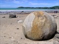
|  Moeraki Boulders. Otago. New Zealand. Moeraki Boulders. Otago. New Zealand.
in Places of Geologic Significance Scattered along the beach at Moeraki, south of Hampden, some 40 kilometers south of Oamaru, these giant boulders are a popular visitor attraction. posted by: Punga and Paua location: South Island, New Zealand date approved: 12/03/2009 last visited: 12/13/2022 |
 view gallery view galleryNE27.8 km |  Hampden Skate Park — Hampden, New Zealand Hampden Skate Park — Hampden, New Zealand
in Skateparks A simple plywood half pipe in a stunning setting in an oceanfront park. posted by: Dunbar Loop location: South Island, New Zealand date approved: 11/25/2009 last visited: never |
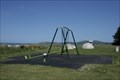 view gallery view galleryNE27.8 km |  Hampden Beach Reserve — Hampden, New Zealand Hampden Beach Reserve — Hampden, New Zealand
in Public Playgrounds A simple playground about 1 km off State Highway 1 between Dunedin and Oamaru offers a good break for young children when travelling. posted by: Dunbar Loop location: South Island, New Zealand date approved: 11/25/2009 last visited: never |
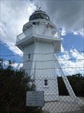 view gallery view galleryE28 km |  Katiki Point Lighthouse - Katiki Point, New Zealand Katiki Point Lighthouse - Katiki Point, New Zealand
in Coastal Lighthouses The Katiki Point Lighthouse is also known as Moeraki Lighthouse. posted by: Marine Biologist location: South Island, New Zealand date approved: 09/30/2020 last visited: never |
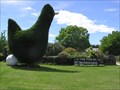 view gallery view galleryNE29.9 km |  The Green Hen. Waianakarua. New Zealand The Green Hen. Waianakarua. New Zealand
in Topiaries A large green hen stands beside the main south highway at Waianakarua, with her freshly layed white egg. posted by: Punga and Paua location: South Island, New Zealand date approved: 04/04/2010 last visited: 04/03/2013 |
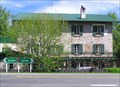 view gallery view galleryNE30.7 km |  Historic Flour Mill. Waianakarua, North Otago. New Zealand. Historic Flour Mill. Waianakarua, North Otago. New Zealand.
in Mills and Gins An old historic Flour Mill at Waianakarua, North Otago has now been converted to a restaurant and guest house. posted by: Punga and Paua location: South Island, New Zealand date approved: 03/12/2011 last visited: 04/03/2013 |
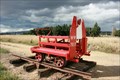 view gallery view gallery W31.1 km W31.1 km
|  ex-NZR WW7517 — Middlemarch, New Zealand ex-NZR WW7517 — Middlemarch, New Zealand
in Railroad Maintenance-Of-Way Equipment Former New Zealand Railways WW7517 is a gangers car that was used to move work gang crews from different locations along the rails. posted by: Dunbar Loop location: South Island, New Zealand date approved: 03/31/2010 last visited: 11/16/2014 |
 view gallery view galleryW31.1 km |  Otago Central Rail Trail — Middlemarch Trailhead Otago Central Rail Trail — Middlemarch Trailhead
in Rails to Trails The 152 kilometre Otago Central Rail Trail is New Zealand's longest and most popular rail trail. The stunning scenery, the historic communities, and the welcoming people bring back people to bike or hike the trail several times. posted by: Dunbar Loop location: South Island, New Zealand date approved: 03/26/2010 last visited: 11/16/2014 |
 view gallery view galleryNE31.1 km | Glencoe Scenic Reserve — Herbert, New Zealand in Campgrounds A beautiful camping location nestled in a small valley near the Waianakarua River's north branch. Only 2 km off of State Highway 1 between Christchurch and Dunedin, this site is very quiet and well worth an overnight's stay. posted by: Dunbar Loop location: South Island, New Zealand date approved: 11/25/2009 last visited: never |
 view gallery view galleryW31.4 km | Bank of New Zealand — Middlemarch, New Zealand in Converted Bank Buildings A simple brick-and-roughcast design Bank of New Zealand once served this agricultural community. posted by: Dunbar Loop location: South Island, New Zealand date approved: 03/28/2010 last visited: 11/16/2014 |
|