 view gallery view gallery S4.7 km S4.7 km
|   Milford Track - New Zealand Milford Track - New Zealand
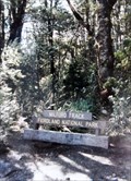
in Wikipedia Entries The Milford Track is a famous 53.5 km (33.2 mi) hiking track near the beautiful Milford Sound on the South Island. posted by:  Metro2 Metro2 location: South Island, New Zealand date approved: 12/03/2013 last visited: 09/01/1986 |
 view gallery view galleryS4.7 km |  A Walk Through New Zealand’s Watery Wild - Milford Track, New Zealand A Walk Through New Zealand’s Watery Wild - Milford Track, New Zealand
in News Article Locations The Milford Track is a famous 53.5 km (33.2 mi) hiking track near the beautiful Milford Sound on the South Island. posted by: Metro2 location: South Island, New Zealand date approved: 02/12/2014 last visited: 09/01/1986 |
 view gallery view galleryS4.7 km |  Milford Track - South Island, New Zealand Milford Track - South Island, New Zealand
in Maori Historic Sites The trail now known as the Milford Track was long-used by the Maori to collect and transport greenstone. posted by: Metro2 location: South Island, New Zealand date approved: 01/24/2014 last visited: 09/01/1986 |
 view gallery view galleryS4.7 km |  Milford Track - New Zealand Milford Track - New Zealand
in There's a Book About It The Milford Track is a famous 53.5 km (33.2 mi) hiking track near the beautiful Milford Sound on the South Island. posted by: Metro2 location: South Island, New Zealand date approved: 12/23/2013 last visited: 09/01/1986 |
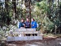
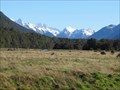
 view gallery view galleryS4.8 km |  Milford Track Milford Track
in Long Distance Hiking Trails One of New Zealand’s four “Great Walks” is located in Fiordland National Park on the South Island, and is part of the Te Wahipounamu – South West New Zealand World Heritage Area. posted by:  Zorkin Queen & The Fox Zorkin Queen & The Fox location: South Island, New Zealand date approved: 01/03/2008 last visited: 09/01/1986 |
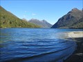
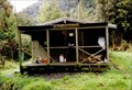
 view gallery view gallery SW10.3 km SW10.3 km
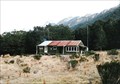
|  Worsley Hut Worsley Hut
in Remote Backcountry Shelters Worsley Hut is situated near the mouth of the Worsley River as it enters Lake TeAnau in the Fiordland National Park. posted by: StagsRoar location: South Island, New Zealand date approved: 12/21/2005 last visited: never |
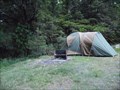 view gallery view gallery E11.3 km E11.3 km
|  Cascade Creek Cascade Creek
in Campgrounds Located on the Milford Highway at Lake Gunn, Fiordland National Park, New Zealand.
Grid reference: NZTM2000, E1211142-N5016992. posted by: StagsRoar location: South Island, New Zealand date approved: 06/03/2012 last visited: 12/28/2022 |
 view gallery view galleryE13.5 km | Lake Gunn - South Island, New Zealand in Wikipedia Entries Small glacial lake along the Milford Sound Highway on the South Island, New Zealand. posted by:  BruceS BruceS location: South Island, New Zealand date approved: 01/09/2013 last visited: 01/26/2019 |
 view gallery view galleryE13.5 km |  Lake Gunn - South Island, New Zealand Lake Gunn - South Island, New Zealand
in Natural Lakes Small glacial lake along the Milford Sound Highway on the South Island, New Zealand. posted by: BruceS location: South Island, New Zealand date approved: 01/09/2013 last visited: 12/28/2022 |
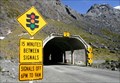 view gallery view gallery N14 km N14 km
|  SH94 Milford Road. Fiordland. New Zealand. SH94 Milford Road. Fiordland. New Zealand.
in National Scenic Byways Milford Road on SH94 provides the only road access to one of New Zealand’s major tourist attractions – Milford Sound. It is also one of the highest highways in New Zealand, with the highest point of the road reaching 940 metres above sea level. posted by: Punga and Paua location: South Island, New Zealand date approved: 05/07/2009 last visited: 03/18/2024 |
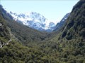
 view gallery view gallery NE15.6 km NE15.6 km
|  Lake Marion Lake Marion
in Scenic Hikes Lake Marion is sited in the Hollyford Valley region of Fiordland, New Zealand. posted by: StagsRoar location: South Island, New Zealand date approved: 06/20/2006 last visited: 12/09/2005 |
 view gallery view galleryNE15.9 km |  Pop's View Look Out - Milford Sound Highway - New Zealand Pop's View Look Out - Milford Sound Highway - New Zealand
in Scenic Roadside Look-Outs Look out on the Milford Sound Highway on South Island, New Zealand. posted by: BruceS location: South Island, New Zealand date approved: 01/09/2013 last visited: 12/28/2022 |
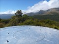
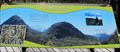 view gallery view galleryNE15.9 km |  Pop's View Orientation Table - Milford Sound Highway - New Pop's View Orientation Table - Milford Sound Highway - New
in Orientation Tables Orientation at look out on the Milford Sound Highway on South Island, New Zealand. posted by: BruceS location: South Island, New Zealand date approved: 01/09/2013 last visited: 12/28/2022 |
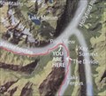 view gallery view galleryNE15.9 km |  Pop's View You Are Here Map - Milford Sound Highway - New Zealand Pop's View You Are Here Map - Milford Sound Highway - New Zealand
in 'You Are Here' Maps A you are here map at look out on Milford Sound Highway on South Island, New Zealand. posted by: BruceS location: South Island, New Zealand date approved: 01/09/2013 last visited: 01/26/2019 |
 view gallery view galleryNE16.1 km | Te Anau -Milford Highway Look Out - New Zealand in Scenic Roadside Look-Outs Look out along the Te Anau -Milford Highway with view of valley below and the surrounding mountains. posted by: BruceS location: South Island, New Zealand date approved: 01/08/2013 last visited: 02/06/2013 |
 view gallery view galleryE16.7 km | McKellar Hut in Remote Backcountry Shelters McKellar Hut is part of the Greenstone Valley walk on Mainland, New Zealand.
Grid reference: Topo50 map sheet CB09, E1216513, N5019822 posted by: StagsRoar location: South Island, New Zealand date approved: 04/21/2006 last visited: never |
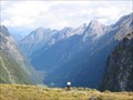
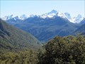
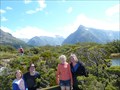 view gallery view galleryNE17.2 km | Key Summit - Fiordland, New Zealand in Scenic Overlooks Key Summit isn't the highest in Fiordland, but getting to the top is recognized as one of the best day walks in this part of New Zealand. And the 360 degree panoramic view from here is fantastic! posted by: Trail Blaisers location: South Island, New Zealand date approved: 01/04/2014 last visited: never |
 view gallery view galleryNE17.2 km | Orientation Table - Key Summit, Fiordland, New Zealand in Orientation Tables This orientation table is located on Key Summit in NZ's beautiful Fiordland District. It takes about a 1.5 hour walk along the Routeburn Track and Key Summit Track to get here from the carpark, but it's worth the effort. posted by: Trail Blaisers location: South Island, New Zealand date approved: 01/05/2014 last visited: never |
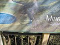
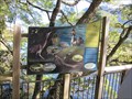 view gallery view galleryS17.2 km |  What's Out There - Mirror Lakes - New Zealand What's Out There - Mirror Lakes - New Zealand
in Flora and Fauna Information Signs Sign about the animals found at Mirror Lakes along the Milford Sound Highway on the South Island, New Zealand. posted by: BruceS location: South Island, New Zealand date approved: 01/15/2013 last visited: 03/18/2024 |
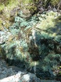 view gallery view galleryNE17.2 km |  Water Spring along Routeburn Track - Fiordland, New Zealand Water Spring along Routeburn Track - Fiordland, New Zealand
in Natural Springs I'm not sure about the potability of this water, but you can splash it on your face to cool down as you climb the path towards Key Summit. posted by: Trail Blaisers location: South Island, New Zealand date approved: 01/04/2014 last visited: never |
 view gallery view galleryS17.2 km | Mirror Lakes You Are Here - Milford Sound Highway - New Zealand in 'You Are Here' Maps You are here map located at observation deck at Mirror Lakes along the Milford Sound Highway on South Island, New Zealand. posted by: BruceS location: South Island, New Zealand date approved: 01/09/2013 last visited: 03/18/2024 |
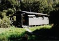
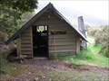
 view gallery view galleryNE17.5 km | Howden Hut in Remote Backcountry Shelters Howden Hut is located on the shores of Lake Howden in the Greenstone Valley posted by: StagsRoar location: South Island, New Zealand date approved: 12/22/2005 last visited: 12/09/2005 |
 view gallery view gallerySW22.5 km | Glaisnock Valley Hut in Remote Backcountry Shelters Glaisnock Hut is sited in the Glaisnock Wilderness Area of Fiordland, New Zealand and is surrounded by pristine Forest & Mountains. posted by: StagsRoar location: South Island, New Zealand date approved: 12/22/2005 last visited: never |
 view gallery view galleryE22.5 km | Steele Creek Hut in Remote Backcountry Shelters Steele Creek Hut is sited in a valley of the same name branching off the Greenstone Valley in the Wakatipu Conservation Area.
Grid reference: Topo50 map sheet CB09, E1222335, N5014107 posted by: StagsRoar location: South Island, New Zealand date approved: 12/27/2005 last visited: never |
 view gallery view galleryS22.7 km | Eglinton River Lookout - Te Anau -Milford Highway - New Zealand in Scenic Roadside Look-Outs Roadside lookout along the Milford Sound Highway affording a view of flats of the Eglinton River and surrounding mountains on the South Island, New Zealand. posted by: BruceS location: South Island, New Zealand date approved: 01/08/2013 last visited: 03/18/2024 |
|