 view gallery view gallery W21.7 km W21.7 km
|   Omarama Merinos — Omarama, New Zealand Omarama Merinos — Omarama, New Zealand
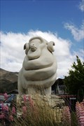
in Figurative Public Sculpture The Omarama Merinos is a tribute to this breed of sheep that thrives in the area. posted by:  Dunbar Loop Dunbar Loop location: South Island, New Zealand date approved: 03/18/2010 last visited: 06/07/2012 |
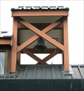 view gallery view galleryW22 km |  St Thomas Anglican Church — Omarama, New Zealand St Thomas Anglican Church — Omarama, New Zealand
in Bell Towers This modern church incorporates very traditional features including a bell tower. posted by: Dunbar Loop location: South Island, New Zealand date approved: 02/01/2010 last visited: 01/17/2015 |
 view gallery view gallery N25.9 km N25.9 km
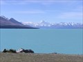
|  Lake Pukaki. South Is. New Zealand. Lake Pukaki. South Is. New Zealand.
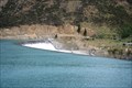
in Natural Lakes Lake Pukaki, a glacial lake in the Mackenzie District has a stunning view across turquoise waters to Mt Cook rising at the northern end of the lake. posted by:  Punga and Paua Punga and Paua location: South Island, New Zealand date approved: 02/20/2012 last visited: 12/27/2022 |
 view gallery view gallery S30.6 km S30.6 km
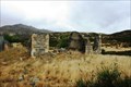
|  Wharekuri, New Zealand Wharekuri, New Zealand
in Ghost Towns This ghost town features the remains of a hotel dating back to 1865. posted by: Dunbar Loop location: South Island, New Zealand date approved: 02/27/2010 last visited: 09/19/2011 |
 view gallery view gallery SE34.6 km SE34.6 km
|  Waitaki Dam — New Zealand Waitaki Dam — New Zealand
in Water Dams The Waitaki Dam was the last dam to built by pick and shovel in New Zealand. Built during the late 1920s and early 1930s it was the first dam to built in the Waitaki reservoir system. posted by: Dunbar Loop location: South Island, New Zealand date approved: 02/25/2010 last visited: 02/25/2010 |
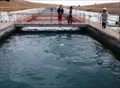 view gallery view galleryN35.4 km |  HIGHEST — Salmon Farm in the World — Mackenzie District, New Zealand HIGHEST — Salmon Farm in the World — Mackenzie District, New Zealand
in Superlatives Located on the Tekapo Canal you will find the highest salmon farm in the world. posted by: Dunbar Loop location: South Island, New Zealand date approved: 04/30/2010 last visited: 11/08/2009 |
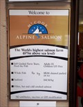 view gallery view galleryN35.4 km |  677 Metres — Mackenzie District, New Zealand 677 Metres — Mackenzie District, New Zealand
in Elevation Signs At 677 metres above sea level you will find the world's highest salmon farm. posted by: Dunbar Loop location: South Island, New Zealand date approved: 04/13/2010 last visited: never |
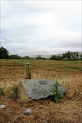
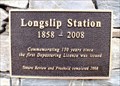 view gallery view galleryW38.3 km |  FIRST — Depasturing License was Issued — Longslip Station, New Zealand FIRST — Depasturing License was Issued — Longslip Station, New Zealand
in First of its Kind At the front gate of Longslip Station this plaque honours the first depasturing license issued to the sheep station in 1858. posted by: Dunbar Loop location: South Island, New Zealand date approved: 02/22/2010 last visited: never |
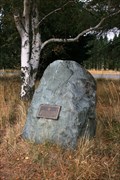
 view gallery view gallerySE40.4 km |  Ron Hill — Kurow, New Zealand Ron Hill — Kurow, New Zealand
in Citizen Memorials Ron Hill remembrance is a metal plaque on a rock on an island in the middle of the Waitaki River. posted by: Dunbar Loop location: South Island, New Zealand date approved: 02/04/2010 last visited: never |
 view gallery view gallerySE40.6 km |  Kurow Hotel — Kurow, New Zealand Kurow Hotel — Kurow, New Zealand
in Antique Hotels Built in 1880 the Kurow Hotel has been serving the Waitaki Valley since then. It is a typical small town hotel offering some rooms, a pub, and some food service that dot this part of New Zealand. posted by: Dunbar Loop location: South Island, New Zealand date approved: 12/07/2009 last visited: 01/18/2015 |
 view gallery view gallery NE44.9 km NE44.9 km
|  Dog Kennel Corner Memorial — Burkes Pass, New Zealand Dog Kennel Corner Memorial — Burkes Pass, New Zealand
in New Zealand Historic Places This New Zealand Historic Places Trust plaque reminds passersby of the importance of sheep dogs especially prior to the fencing of the high country. posted by: Dunbar Loop location: South Island, New Zealand date approved: 04/09/2010 last visited: 02/20/2011 |
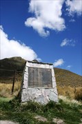 view gallery view gallery SW49.6 km SW49.6 km
| FIRST — Liberation of Red Deer in Otago — Lindis Pass, New Zealand in First of its Kind On the 100th anniversary of the first liberation of red deer in Otago, the New Zealand Deerstalkers Association erected this monument. It is reminder that most mammals in New Zealand are introduced species. posted by: Dunbar Loop location: South Island, New Zealand date approved: 11/23/2009 last visited: 02/21/2015 |
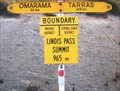 view gallery view gallerySW49.7 km |  Waitaki / Central Otago. New Zealand. Waitaki / Central Otago. New Zealand.
in Border Crossings This sign at Lindis Pass shows the boundary between the South Island districts of Waitaki and Central Otago. posted by: Punga and Paua location: South Island, New Zealand date approved: 05/13/2009 last visited: 05/13/2009 |
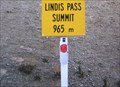 view gallery view gallerySW49.7 km | Lindis Pass - 965 metres. South Island, New Zealand. in Elevation Signs Lindis Pass, elevation 965 metres, lies between the towns of Cromwell and Omarama in Otago, on the main inland route to the Mackenzie Basin in Canterbury. posted by: Punga and Paua location: South Island, New Zealand date approved: 05/07/2009 last visited: 11/16/2009 |
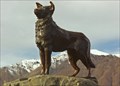 view gallery view galleryNE50.4 km |  Mackenzie Sheep Dog - South Island, New Zealand Mackenzie Sheep Dog - South Island, New Zealand
in Dog Statues The bronze statue of the dog on the shores of Lake Tekapo is dedicated to the working collie dogs of the Mackenzie Country and was commissioned on the 7th of March, 1968. posted by: Punga and Paua location: South Island, New Zealand date approved: 06/20/2008 last visited: 04/05/2013 |
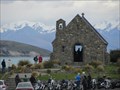 view gallery view galleryNE50.4 km |  Good Shepherd Waychapel, Tekapo, New Zealand Good Shepherd Waychapel, Tekapo, New Zealand
in Waychapels The Chapel of the Good Shepherd at Lake Tekapo is a favourite place to visit and photograph posted by: arby101ca location: South Island, New Zealand date approved: 12/16/2012 last visited: 12/27/2022 |
 view gallery view galleryN51.5 km |  6702 MT JOHN — Lake Tekapo, New Zealand 6702 MT JOHN — Lake Tekapo, New Zealand
in Australia/NZ Benchmarks At the top of Mt. John amongst the observatory buildings you can find this trig site. posted by: Dunbar Loop location: South Island, New Zealand date approved: 04/13/2010 last visited: 12/27/2022 |
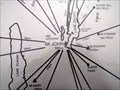 view gallery view galleryN51.7 km | 1031 metres — Lake Tekapo, New Zealand in Elevation Signs At the centre of the Mount John Orientation Table is this elevation marker saying 1031 metres. posted by: Dunbar Loop location: South Island, New Zealand date approved: 04/13/2010 last visited: never |
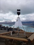
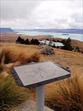 view gallery view galleryN51.7 km |  Mt John Orientation Table — Lake Tekapo, New Zealand Mt John Orientation Table — Lake Tekapo, New Zealand
in Orientation Tables Near the Astro Cafe atop of Mt John is this orientation table. posted by: Dunbar Loop location: South Island, New Zealand date approved: 04/13/2010 last visited: never |
 view gallery view galleryN51.7 km |  Mt John University Observatory. Tekapo. New Zealand. Mt John University Observatory. Tekapo. New Zealand.
in Astronomical Observatories Mt John Observatory is a high-tech research observatory, founded in 1965 as a joint project between the universities of Pennsylvania and Canterbury. It is at Lake Tekapo, in the centre of New Zealand’s South Island. posted by: Punga and Paua location: South Island, New Zealand date approved: 07/15/2009 last visited: 12/27/2022 |
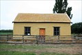 view gallery view gallerySE55.7 km | Paterson's Cottage — Hakataramea, New Zealand in New Zealand Historic Places A restored cob cottage just off of SH 82 near Hakataramea is occasionally open to the public to see what life was like in the 1880s posted by: Dunbar Loop location: South Island, New Zealand date approved: 03/03/2010 last visited: never |
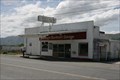 view gallery view gallerySE61 km |  Duntroon Garage — Duntroon, New Zealand Duntroon Garage — Duntroon, New Zealand
in Vintage Gas Stations A garage in a town of about 120 people. Today it no longer pumps petrol but is still in use a post office box location and a repair for vehicles. posted by: Dunbar Loop location: South Island, New Zealand date approved: 11/23/2009 last visited: 11/08/2009 |
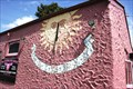 view gallery view gallerySE61 km |  Sundial at The Flying Pig — Duntroon, New Zealand Sundial at The Flying Pig — Duntroon, New Zealand
in Sundials A vertical sundial on the wall of a cafe. posted by: Dunbar Loop location: South Island, New Zealand date approved: 12/02/2009 last visited: 11/08/2009 |
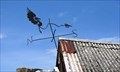 view gallery view gallerySE61 km |  Modern-day stork on the Nicol's Forge — Duntroon, New Zealand Modern-day stork on the Nicol's Forge — Duntroon, New Zealand
in Unique Weathervanes This definitely a one-of-a-kind weathervane on top of Nicol's Forge in Duntroon. A modern-day stork is about the only way to describe it. posted by: Dunbar Loop location: South Island, New Zealand date approved: 12/04/2009 last visited: 11/08/2009 |
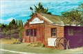 view gallery view gallerySE61 km |  Nichol’s Forge. Duntroon. Otago. New Zealand. Nichol’s Forge. Duntroon. Otago. New Zealand.
in Blacksmith Shops Nichol’s Blacksmith Shop was founded in the 1890s, catering to the needs of horses and horse-drawn vehicles as well as making tools and equipment for farmers. Today it is very much in its original condition. posted by: Punga and Paua location: South Island, New Zealand date approved: 10/01/2009 last visited: 11/19/2009 |
|