 view gallery view gallery E48.6 km E48.6 km
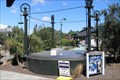
|   The Hanmer Springs Gasometer, The Hanmer Springs Gasometer,
in Gasometers This gasometer was commisioned in 1898 and supplied gas to the sanitorium. It was decommisioned in 1940 when the town was connected to the national grid. posted by:  greysman greysman location: South Island, New Zealand date approved: 03/27/2011 last visited: 03/07/2013 |
  NE68.2 km NE68.2 km
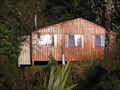
|  John Tait Hut - Travers Valley _ Nelson Lakes National Park John Tait Hut - Travers Valley _ Nelson Lakes National Park
in Remote Backcountry Shelters A serviced DoC Hut in the Travers Valley posted by: madiecacher location: South Island, New Zealand date approved: 07/28/2008 last visited: never |
 view gallery view galleryNE68.9 km | D'urville Hut in Remote Backcountry Shelters Sited at the head of Lake Rotoroa in the Nelson Lakes Park posted by:  StagsRoar StagsRoar location: South Island, New Zealand date approved: 12/28/2005 last visited: never |
 view gallery view gallery SW70 km SW70 km
|  Otira, New Zealand Otira, New Zealand
in Train Stations/Depots Otira train station is a part of the Tranz Alpine track and is 'Otira' railway tunnel. posted by: superstein location: South Island, New Zealand date approved: 03/16/2015 last visited: never |
 view gallery view gallerySW70 km |  Otira, New Zealand, 1239 feet Otira, New Zealand, 1239 feet
in Elevation Signs A elevation sign on Otira railwaystation. posted by: superstein location: South Island, New Zealand date approved: 03/15/2015 last visited: never |
 view gallery view gallery N72.3 km N72.3 km
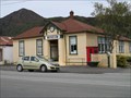
|  Murchison Museum - Murchison, New Zealand Murchison Museum - Murchison, New Zealand
in History Museums This small museum is located on Fairfax Street in Murchison. It opened on 15th December 1989. posted by: denben location: South Island, New Zealand date approved: 01/20/2015 last visited: never |
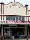 view gallery view galleryN72.4 km |  Hodgson's Store and Stables - Murchison, New Zealand Hodgson's Store and Stables - Murchison, New Zealand
in New Zealand Historic Places Hodgson's Store is located on Fairfax Street in Murchison, South Island. The stables are directly behind the store and are accessible via a driveway immediately south of the store. posted by: denben location: South Island, New Zealand date approved: 01/21/2015 last visited: 01/23/2015 |
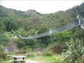 view gallery view galleryN74.7 km |  Buller Gorge Swing Bridge Buller Gorge Swing Bridge
in Pedestrian Suspension Bridges Buller Gorge Swing Bridge, New Zealand's longest foot bridge. posted by: thebigchip location: New Zealand date approved: 05/04/2009 last visited: 03/13/2024 |
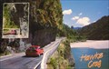 view gallery view gallery NW75.3 km NW75.3 km
|  Hawks Crag, Buller Gorge. New Zealand. Hawks Crag, Buller Gorge. New Zealand.
in Picture Perfect Postcards Postcard showing the road through the forbidding Buller Gorge. At Hawks Crag the road has been hacked out of solid rock – you’ll drive under a dramatic overhang. posted by: Punga and Paua location: North Island, New Zealand date approved: 10/08/2009 last visited: 03/15/2024 |
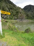 view gallery view galleryNW75.5 km |  Kilkenny Lookout - Lower Buller, West Coast, New Zealand Kilkenny Lookout - Lower Buller, West Coast, New Zealand
in Scenic Roadside Look-Outs Kilkenny Lookout is located on Lower Buller Gorge Road (State Highway 6) near Westport. posted by: denben location: South Island, New Zealand date approved: 01/20/2015 last visited: 03/15/2024 |
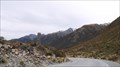 view gallery view gallerySW75.8 km |  Arthur Dudley Dobson - Arthers Pass - New Sealand Arthur Dudley Dobson - Arthers Pass - New Sealand
in Obelisks obelisks in memory of Athhur Dudley Dobson. posted by: superstein location: South Island, New Zealand date approved: 02/28/2021 last visited: never |
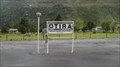
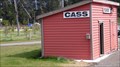 view gallery view gallerySW76.4 km | Cass - New Zealand in Train Stations/Depots Small railwaystation on the trackline Christchurch - Graymouth. posted by: superstein location: South Island, New Zealand date approved: 03/28/2015 last visited: 09/06/2015 |
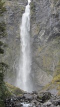 view gallery view gallerySW77.4 km |  devil's punchbowl waterfall, New zealand devil's punchbowl waterfall, New zealand
in Waterfalls One of the most impressive waterfalls in New Zealand, Devils Punchbowl Falls is located in the heart of Arthur's Pass National Park posted by: superstein location: South Island, New Zealand date approved: 01/12/2015 last visited: 11/20/2016 |
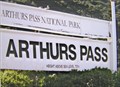
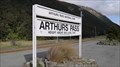 view gallery view gallerySW78.2 km | Arthur's Pass - New Zealand in Train Stations/Depots Arthur's Pass railway station is a part of the 'TranzAlpine' track between Christchurch and Greymouth posted by: superstein location: South Island, New Zealand date approved: 05/07/2015 last visited: 11/19/2016 |
 view gallery view gallerySW78.2 km | Arthurs Pass Station - 737metres. New Zealand. in Elevation Signs An elevation sign at the Arthurs Pass Railway Station platform, 737 metres above sealevel. posted by: Punga and Paua location: South Island, New Zealand date approved: 05/07/2009 last visited: 11/19/2016 |
 view gallery view galleryNE79.7 km | Lake Head Hut - Travers Valley in Remote Backcountry Shelters Located at the head of Lake Rotoiti at the outlet of the Travers River posted by: StagsRoar location: South Island, New Zealand date approved: 12/27/2005 last visited: never |
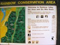 view gallery view galleryNE81.6 km |  You Are Here at Rainbow Conservation Area. South Is. New Zealand. You Are Here at Rainbow Conservation Area. South Is. New Zealand.
in 'You Are Here' Maps "You Are Here" at the base of the Rainbow Ski Field Road in the Six Mile Basin at Rainbow Conservation Area. posted by: Punga and Paua location: South Island, New Zealand date approved: 04/30/2009 last visited: 04/30/2009 |
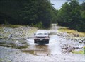 view gallery view galleryNE81.8 km |  Six Mile Creek. Rainbow Valley. South Is. New Zealand. Six Mile Creek. Rainbow Valley. South Is. New Zealand.
in Bridgeless Water Crossings Six Mile Creek crosses the wilderness Rainbow Road linking St Arnaud and Hanmer Springs. There is a rough ford where the road crosses the stream just past the Rainbow Ski Area turn-off, 26 km from the Wairau Valley road end. posted by: Punga and Paua location: South Island, New Zealand date approved: 04/30/2009 last visited: 09/05/2009 |
NE82.7 km | Relax Shelter - Mount Robert_Nelson Lakes National Park_NZ in Remote Backcountry Shelters A DoC shelter on Mount Robert, Nelson Lakes National Park posted by: madiecacher location: South Island, New Zealand date approved: 08/03/2008 last visited: 01/23/2010 |
NE83 km | Bushedge Shelter - Mount Robert_Nelson Lakes National Park NZ in Remote Backcountry Shelters A DoC shelter on the "Pinchgut" track up Mount Robert posted by: madiecacher location: South Island, New Zealand date approved: 08/03/2008 last visited: 01/23/2010 |
NE83.2 km | Bushline Hut - Mount Robert_Nelson Lakes National Park_NZ in Remote Backcountry Shelters A serviced DoC hut in Nelson Lakes National Park posted by: madiecacher location: South Island, New Zealand date approved: 08/03/2008 last visited: 01/08/2011 |
 view gallery view galleryNW83.7 km |  Punakaiki Resort - Punakaiki, New Zealand Punakaiki Resort - Punakaiki, New Zealand
in Recommended Accommodation Punakaiki Resort is located on New Zealand's wild West Coast at about 350m south of the famous Pancakes Rocks and Blowholes. posted by: denben location: South Island, New Zealand date approved: 01/21/2015 last visited: 01/23/2015 |
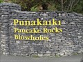 view gallery view galleryNW83.8 km |  Pancake Rocks & Blowholes - Dolomite Point - Punakaiki, New Zealand Pancake Rocks & Blowholes - Dolomite Point - Punakaiki, New Zealand
in Official Local Tourism Attractions The entrance to Pancake Rocks & Blowholes is located opposite the Paparoa National Park Visitors Centre at Dolomite Point, Punakaiki, West Coast. posted by: denben location: South Island, New Zealand date approved: 01/20/2015 last visited: 11/19/2016 |
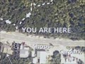 view gallery view galleryNW83.8 km | You Are Here - Pancake Rocks & Blowholes - Punakaiki, New Zealand in 'You Are Here' Maps Map at the entrance to Pancake Rocks & Blowholes located opposite the Paparoa National Park Visitors Centre at Dolomite Point, Punakaiki, West Coast. posted by: denben location: South Island, New Zealand date approved: 01/21/2015 last visited: 03/15/2024 |
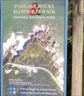 view gallery view galleryNW83.8 km |  Pancake Rocks & Blowholes Walk - Paparoa National Park - Punakaiki, New Zealand Pancake Rocks & Blowholes Walk - Paparoa National Park - Punakaiki, New Zealand
in Hiking and walking trailheads The Pancake Rocks & Blowholes Trailhead is located at the entrance to Pancake Rocks & Blowholes opposite the Paparoa National Park Visitors Centre at Dolomite Point, Punakaiki, West Coast. posted by: denben location: South Island, New Zealand date approved: 01/21/2015 last visited: 11/19/2016 |
|