 view gallery view gallery NE71.1 km NE71.1 km
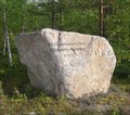
|   Road Completion Marker, VT21 Torniontie, Muonio, Finland Road Completion Marker, VT21 Torniontie, Muonio, Finland
in Milestones A roadside marker commemorating the completion of surfacing of the road from Kemi to Kilpisjärvi in 1971. posted by:  Team Sieni Team Sieni location: Finland date approved: 04/05/2012 last visited: 09/01/2022 |
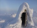 view gallery view galleryNE83 km |  Särkitunturi, Lappi, Finland Särkitunturi, Lappi, Finland
in Outhouses Part of the facilities provided by Metsähallitus on the top of Särkitunturi. There used to be a kota nearby, but it is no longer standing. posted by: Team Sieni location: Finland date approved: 02/22/2013 last visited: 08/26/2020 |
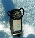 view gallery view galleryNE85.8 km |  Särkijärven koira Särkijärven koira
in GPS Tracklog Art We drew this dog on the frozen Särkijärvi lake wearing snowshoes. posted by: Team Sieni location: Finland date approved: 03/06/2011 last visited: never |
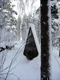 view gallery view galleryNE94.6 km | Vuontisjärvi Metsähallitus facility in Outhouses Part of the facilities provided by Metsähallitus on the Western shore of Vuontisjärvi in the Pallas-Yllästunturi National Park. posted by: Team Sieni location: Finland date approved: 03/05/2011 last visited: never |
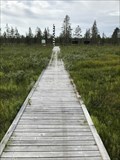 view gallery view gallery SW100.1 km SW100.1 km
|  Arctic Circle Boardwalk - Nattavaara, Sweden Arctic Circle Boardwalk - Nattavaara, Sweden
in Non-Coastal Boardwalks Boardwalk leading into the Arctic Circle Monument and the Ore Road. posted by:  Walking Boots Walking Boots location: Norrbotten, Sweden date approved: 01/16/2022 last visited: never |
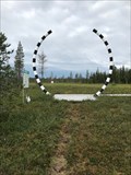 view gallery view gallerySW100.1 km |  Arctic Circle - The Magic Circle - Nattavaara, Sweden Arctic Circle - The Magic Circle - Nattavaara, Sweden
in Great Lines of Earth After a couple of hours driving on gravel roads in Swedish Lapland, you pass the Arctic Circle, which here is marked with a monument, The Magic Circle posted by: Walking Boots location: Norrbotten, Sweden date approved: 08/17/2021 last visited: never |
 view gallery view gallerySW100.1 km |  Malmens väg - Nattavaara, Sweden Malmens väg - Nattavaara, Sweden
in Offroad Trails The Ore Road is a historic road from 1745 where you can only ride a snowmobile or ATV posted by: Walking Boots location: Norrbotten, Sweden date approved: 01/13/2022 last visited: never |
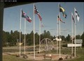
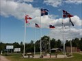 view gallery view gallery SE101.5 km SE101.5 km
|  Polar Circle Monument in Juoksengi - Övertorneå, Norrbottens Län, Sweden Polar Circle Monument in Juoksengi - Övertorneå, Norrbottens Län, Sweden
in Flags of the World Flags of the eight countries that touch the Arctic Circle in Juoksengi. posted by: FamilieFrohne location: Norrbotten, Sweden date approved: 01/09/2021 last visited: never |
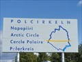 view gallery view gallerySE101.5 km | Arctic Circle Monument Juoksengi - Övertorneå. Norrbottens Län, Sweden. in Great Lines of Earth Arctic Circle Monument in Juoksengi in Övertoneå County (Norrbottens Län, Sweden). posted by: FamilieFrohne location: Norrbotten, Sweden date approved: 01/09/2021 last visited: never |
 view gallery view gallerySE101.5 km |  WebCam - Juoksengi , Sweden. WebCam - Juoksengi , Sweden.
in Web Cameras Polcirklen - Juoksengi , Sweden. posted by: dvddragon location: Norrbotten, Sweden date approved: 07/14/2021 last visited: never |
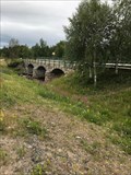 view gallery view gallery N111 km N111 km
|  Idivioma Arch Bridge - Idivioma - Sweden Idivioma Arch Bridge - Idivioma - Sweden
in Arch Bridges From Europaväg 45 you can see this stone bridge with three arches posted by: Walking Boots location: Norrbotten, Sweden date approved: 09/20/2021 last visited: never |
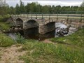 view gallery view galleryN111 km |  Idivioma Arch Bridge - Idivioma - Sweden Idivioma Arch Bridge - Idivioma - Sweden
in Stone Bridges From Europaväg 45 you can see this stone bridge with three arches posted by: Walking Boots location: Norrbotten, Sweden date approved: 09/19/2021 last visited: never |
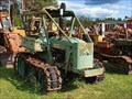 view gallery view gallery S117.6 km S117.6 km
|  ÖSA BMB 230 "Bamse" - Överkalix, Norrbottens Län, Sweden ÖSA BMB 230 "Bamse" - Överkalix, Norrbottens Län, Sweden
in Old Tractors There are lots of tractors in "Holgers Traktormuseum" in Överkalix, mainly from the 1920ies to the 1970ies. posted by: FamilieFrohne location: Norrbotten, Sweden date approved: 07/27/2023 last visited: never |
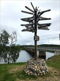 view gallery view galleryN123.3 km |  Direction Arrows - Swedish/Finnish border - Karesuando, Sweden Direction Arrows - Swedish/Finnish border - Karesuando, Sweden
in Direction and Distance Arrows At the Swedish / Finnish border you can see these direction and distance arrows posted by: Walking Boots location: Norrbotten, Sweden date approved: 09/30/2021 last visited: 07/18/2023 |
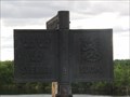
 view gallery view galleryN123.3 km |  68.27.N 22.29.E - Swedish/Finnish border - Karesuando, Sweden 68.27.N 22.29.E - Swedish/Finnish border - Karesuando, Sweden
in Permanent Geographic Coordinates At the Swedish / Finnish border there is this sign where you can read the coordinate 68.27.N 22.29.E posted by: Walking Boots location: Norrbotten, Sweden date approved: 09/25/2021 last visited: 07/17/2023 |
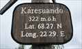
 view gallery view galleryN123.3 km |  322 meter - Swedish/Finnish border - Karesuando, Sweden 322 meter - Swedish/Finnish border - Karesuando, Sweden
in Elevation Signs Elevation sign which is close to the Swedish-Finnish border posted by: Walking Boots location: Norrbotten, Sweden date approved: 09/18/2021 last visited: 07/18/2023 |
 view gallery view galleryN123.4 km |  The Northenmost Border crossing between Finland and Sweden The Northenmost Border crossing between Finland and Sweden
in Border Crossings The northen border crossing between Finland and Sweden. posted by: Mirtilli location: Finland date approved: 07/13/2010 last visited: 07/18/2023 |
 view gallery view galleryN126.8 km |  Jyppyrä Fell, Hetta, Finland Jyppyrä Fell, Hetta, Finland
in Orientation Tables Jyppyrä Hill overlooking Hetta in Finnish Lapland posted by: Team Sieni location: Finland date approved: 09/13/2008 last visited: 09/24/2023 |
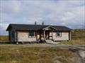 view gallery view galleryN160.1 km |  Pöyrisjärvi tupa, Finland Pöyrisjärvi tupa, Finland
in Remote Backcountry Shelters Metsähallitus maintained hut on the shore of Pöyrisjärvi posted by: Team Sieni location: Finland date approved: 09/04/2011 last visited: never |
|