 view gallery view gallery N17.7 km N17.7 km
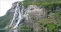
|   Seven Sisters Waterfall, Stranda, Møre og Romsdal, Norway Seven Sisters Waterfall, Stranda, Møre og Romsdal, Norway
in Waterfalls The beautiful waterfall with a nice legend. posted by:  g300td g300td location: Møre og Romsdal, Norway date approved: 01/06/2013 last visited: 06/29/2023 |
 view gallery view gallery NE17.7 km NE17.7 km
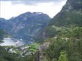
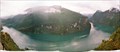
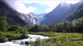
|  West Norwegian Fjords Geirangerfjord and Nærøyfjord - Norway West Norwegian Fjords Geirangerfjord and Nærøyfjord - Norway
in World Heritage Sites The Geiranger fjord (Geirangerfjorden) is a fjord in the Sunnmøre region, located in the southernmost part of the county Møre og Romsdal in Norway. It is a 15 km long branch of the Storfjord (Great Fjord). At the head in the fjord lies the small village of Geiranger. posted by: haxepaxe location: Møre og Romsdal, Norway date approved: 08/12/2009 last visited: 06/29/2023 |
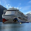 view gallery view galleryN18.7 km |  Cruise Terminal, Geiranger, Norway Cruise Terminal, Geiranger, Norway
in Cruise Ship Ports Geiranger (Norway) Cruise Terminal posted by: Hatti75 location: Møre og Romsdal, Norway date approved: 05/17/2023 last visited: 06/29/2023 |
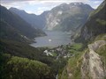 view gallery view galleryN18.7 km |  Geirangerfjord - Geiranger, Norway Geirangerfjord - Geiranger, Norway
in 1000 Places to See Before You Die If you are enamored of mountains, coastlines and waterfalls then Geirangerfjord, arguably, offers the most spectacular scenery on the planet. posted by:  neoc1 neoc1 location: Møre og Romsdal, Norway date approved: 06/21/2011 last visited: 06/29/2023 |
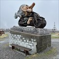
 view gallery view galleryN18.7 km |  Troll - Geiranger, Norway Troll - Geiranger, Norway
in Epic Beings and Creatures Trolls are everywhere in Norway. When you reach the dock at Geiranger you cannot miss seeing this one. posted by: neoc1 location: Møre og Romsdal, Norway date approved: 06/26/2011 last visited: 06/29/2023 |
 view gallery view galleryN19.5 km | West Norwegian Fjords - Geirangerfjord Area in World Heritage Sites In August/September 2004 I was in Norway travelling the famous Coastal Express "Hurtigruten". The travel began in Bergen and followed the coast until the Norwegian/Russian borderline. During this journey I visited 2 UNESCO sites: Bryggen and the Geirangerfjord. posted by:  Stream_Green Stream_Green location: Møre og Romsdal, Norway date approved: 05/25/2006 last visited: 06/29/2023 |
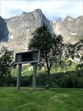
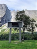
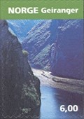 view gallery view galleryN20.4 km |  Geiranger Fjord and the Seven Sisters Waterfalls from the Eagle's Road View Point - Geiranger, Norway Geiranger Fjord and the Seven Sisters Waterfalls from the Eagle's Road View Point - Geiranger, Norway
in Philatelic Photographs Geiranger Fjord and the Seven Sisters Waterfalls from the Eagle's Road viewing point. posted by: neoc1 location: Møre og Romsdal, Norway date approved: 08/06/2011 last visited: 06/29/2023 |
 view gallery view gallery S28 km S28 km
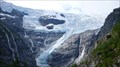
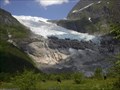
|  Jostedalsbreen, Sogn og Fjordane, Norway Jostedalsbreen, Sogn og Fjordane, Norway
in Glaciers The largest glacier in continental Europe posted by: g300td location: Vestland, Norway date approved: 03/07/2013 last visited: 06/28/2023 |
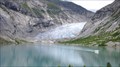 view gallery view galleryS29.8 km | Nigardsbreen, Luster, Norway in Glaciers A breathtaking landscape posted by: g300td location: Vestland, Norway date approved: 03/07/2013 last visited: 07/23/2012 |
 view gallery view galleryS33.5 km | Briksdalsbreen, Stryn, Sogn og Fjordane, Norway in Glaciers Glaciologists speculate that the size of the glacier was at its smallest since the 13th century. posted by: g300td location: Vestland, Norway date approved: 03/07/2013 last visited: 09/06/2018 |
 view gallery view galleryS53.9 km | Bøyabreen Glacier - Fjærland, Norway in Glaciers Bøyabreen Glacier - Fjærland, Norway posted by: neoc1 location: Rogaland, Norway date approved: 10/26/2011 last visited: 06/28/2023 |
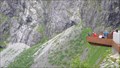 view gallery view galleryNE64.2 km |  Trollstigen - Overlook, Rauma Municipality, Møre og Romsdal, Norway Trollstigen - Overlook, Rauma Municipality, Møre og Romsdal, Norway
in Scenic Overlooks A breathtaking view from the platform. posted by: g300td location: Møre og Romsdal, Norway date approved: 10/21/2014 last visited: 06/29/2023 |
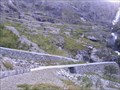 view gallery view galleryNE64.7 km |  Troll's Path (Trollstigen) - Åndalsnes - Norway Troll's Path (Trollstigen) - Åndalsnes - Norway
in National Scenic Byways The Troll's Path is a mountain road in Møre og Romsdal, Norway, part of Norwegian National Road 63 connecting Åndalsnes in Rauma and Valldal in Norddal. posted by: Megrim1888 location: Møre og Romsdal, Norway date approved: 02/06/2012 last visited: 06/29/2023 |
 view gallery view galleryNE68.9 km | Troll - Andalsnes, Norway in Epic Beings and Creatures This troll is standing with his motorbike on the access road to the Trollstigen. posted by: Hatti75 location: Møre og Romsdal, Norway date approved: 05/20/2023 last visited: 07/01/2023 |
 view gallery view galleryNE70 km |  Troll Wall - Åndalsnes, Norway Troll Wall - Åndalsnes, Norway
in Wikipedia Entries The Troll wall (Troldveggen) and the surrounding mountains in Romsdalen is a well-known area for climbing. posted by: Walking Boots location: Møre og Romsdal, Norway date approved: 09/29/2021 last visited: 06/29/2023 |
 view gallery view galleryNE70 km |  Troll Wall - Åndalsnes, Norway Troll Wall - Åndalsnes, Norway
in Established Rock Climbing Areas The Troll wall (Troldveggen) and the surrounding mountains in Romsdalen is a well-known area for climbing. posted by: Walking Boots location: Møre og Romsdal, Norway date approved: 08/13/2021 last visited: 06/29/2023 |
 view gallery view galleryNE70 km | Troll -Troll Wall - Åndalsnes, Norway in Epic Beings and Creatures In the rest area by The Troll Wall there is a large troll posted by: Walking Boots location: Møre og Romsdal, Norway date approved: 11/08/2021 last visited: 06/29/2023 |
 view gallery view galleryNE70 km |  Troll Wall: The Untold Story of the British First Ascent of Europe's Tallest Rock Face - Åndalsnes, Norway Troll Wall: The Untold Story of the British First Ascent of Europe's Tallest Rock Face - Åndalsnes, Norway
in There's a Book About It A gripping story of one of the most dramatic first ascents in British climbing history. posted by: Walking Boots location: Møre og Romsdal, Norway date approved: 11/07/2021 last visited: 06/29/2023 |
 view gallery view galleryS73.4 km | Urnes Stave Church, Ornes, Norway in World Heritage Sites The wooden church of Urnes posted by: g300td location: Norway date approved: 01/06/2013 last visited: 06/11/2013 |
 view gallery view galleryS73.4 km | Urnes Stave Church, Ornes, Norway in Wikipedia Entries The wooden church of Urnes posted by: g300td location: Norway date approved: 11/09/2014 last visited: never |
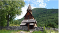
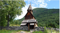 view gallery view galleryS73.4 km |  Urnes Stave Church, Ornes, Norway Urnes Stave Church, Ornes, Norway
in This Old Church The wooden church of Urnes posted by: g300td location: Norway date approved: 11/08/2014 last visited: never |
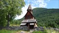 view gallery view galleryS73.9 km |  Urnes Stave Church, Ornes, Norway Urnes Stave Church, Ornes, Norway
in Medieval Churches The wooden church of Urnes posted by: g300td location: Norway date approved: 01/07/2013 last visited: 06/11/2013 |
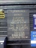 view gallery view galleryN74.8 km |  Lake Hornindalsvatnet, Norway Lake Hornindalsvatnet, Norway
in Natural Lakes Hornindalsvanet is Europe's deepest lake, offically measured to a depth of 514 meters (1665 feet). Its surface is 53 meters (256 feet ) above sea level and the bottom is about 461 meters (1494 feet ) below sea level. posted by: 2Hanweb location: Møre og Romsdal, Norway date approved: 08/14/2015 last visited: never |
 view gallery view gallery NW75.3 km NW75.3 km
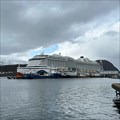
| Cruise Terminal, Ålesund, Norway in Cruise Ship Ports Alesund (Norway) Cruise Terminal posted by: Hatti75 location: Møre og Romsdal, Norway date approved: 05/17/2023 last visited: 06/29/2023 |
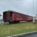 view gallery view galleryNE76 km | Andalsnes Train Chapel, Andalsnes, Norway in Waychapels The Andalsnes Train Chapel is located directly at the port of the small town behind the Norwegian Mountaineering Centre. posted by: Hatti75 location: Møre og Romsdal, Norway date approved: 05/19/2023 last visited: 07/01/2023 |
|