 view gallery view gallery W7.4 km W7.4 km
|   Nenthead camera, Cumbria Nenthead camera, Cumbria
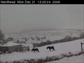
in Web Cameras High up on North Pennine Moor are a collection of cameras. Nenthead camera looks across the village of Nenthead towards a plantation beside Fiddler's Street. There is a road in view. Watch the horses in the field. Looking south west. Time zone GMT. posted by:  flipflopnick flipflopnick location: North West England, United Kingdom date approved: 12/28/2009 last visited: never |
 view gallery view gallery NE7.4 km NE7.4 km
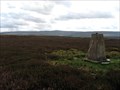
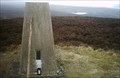
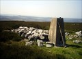
|  Dry Rigg Dry Rigg
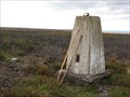
in U.K. and Ireland Trigpoints Pillar trigpoint on Dry Rigg. posted by: Bambi&Thumper location: United Kingdom date approved: 09/09/2006 last visited: 08/18/2014 |
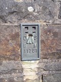 view gallery view galleryW8.9 km | FLUSH BRACKET, ASHGILL BRIDGE in U.K. and Ireland Trigpoints A flush bracket on a bridge in Cumbria. posted by: plymplodder location: United Kingdom date approved: 04/22/2008 last visited: 04/16/2008 |
 view gallery view galleryW8.9 km |  Ashgill Force bridge, near Alston in Cumbria Ashgill Force bridge, near Alston in Cumbria
in Arch Bridges A brick and stone arched bridge on the B6277 at Ashgillside in Cumbria. posted by: Sir Lose-a-lot location: United Kingdom date approved: 04/23/2008 last visited: 10/12/2013 |
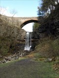
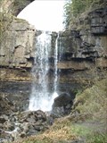 view gallery view galleryW8.9 km |  Ashgill Force Ashgill Force
in Waterfalls A great waterfall under Ashgill bridge on B6277 between Alston and Middleton in Teesdale. posted by: Sir Lose-a-lot location: North West England, United Kingdom date approved: 04/24/2008 last visited: 10/12/2013 |
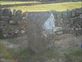
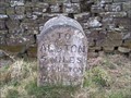 view gallery view galleryW8.9 km |  MILESTONE, ASHGILLSIDE, CUMBRIA MILESTONE, ASHGILLSIDE, CUMBRIA
in Milestones A milestone in Cumbria. posted by: plymplodder location: United Kingdom date approved: 04/22/2008 last visited: 04/16/2008 |
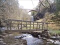 view gallery view galleryW9 km |  FOOTBRIDGE NEAR GARRIGILL, CUMBRIA FOOTBRIDGE NEAR GARRIGILL, CUMBRIA
in Hiking Path Footbridges A footbridge in Cumbria. posted by: plymplodder location: United Kingdom date approved: 04/22/2008 last visited: 04/16/2008 |
 view gallery view gallery N10 km N10 km
| Harwood Side in U.K. and Ireland Trigpoints Pillar trigpoint on Harwood Side. posted by: Bambi&Thumper location: United Kingdom date approved: 05/09/2007 last visited: never |
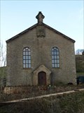
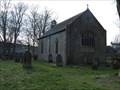 view gallery view galleryW10.1 km |  THE CHURCH AND CHAPELRY OF ST. JOHN THE EVANGELIST, GARRIGILL THE CHURCH AND CHAPELRY OF ST. JOHN THE EVANGELIST, GARRIGILL
in This Old Church A small church in Garrigill, a village deep in the North Pennines posted by: Sir Lose-a-lot location: United Kingdom date approved: 04/21/2008 last visited: 04/16/2008 |
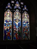 view gallery view galleryW10.1 km |  Stained glass window in St John The Evangelist, Garrigill, UK Stained glass window in St John The Evangelist, Garrigill, UK
in Stained Glass Windows The stained glass North window was inserted in 1904. It depicts the Crucifixion and is in memory of George Monkhouse, Curate in Charge from 1851 to 1876. posted by: Sir Lose-a-lot location: United Kingdom date approved: 04/23/2008 last visited: 04/16/2008 |
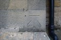
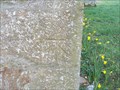 view gallery view galleryW10.1 km | CUT BENCH MARK, GARRIGILL CHURCH in U.K. and Ireland Trigpoints A bench mark on a church in Cumbria. posted by: plymplodder location: United Kingdom date approved: 04/23/2008 last visited: 04/16/2008 |
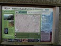 view gallery view galleryW10.1 km |  Open Access Notice Board in Garrigill, Cumbria Open Access Notice Board in Garrigill, Cumbria
in 'You Are Here' Maps This notice board gives walkers information about access and the right to roam on local moorland. posted by: Sir Lose-a-lot location: United Kingdom date approved: 04/24/2008 last visited: 04/16/2008 |
 view gallery view galleryW10.3 km | Former Wesleyan Methodist Chapel, Garrigill, Cumbria in This Old Church This disused chapel is one of several in Garrigill. There used to be at least 3 non-comformist or methodist chapels in the village. posted by: Sir Lose-a-lot location: United Kingdom date approved: 09/04/2008 last visited: 04/23/2008 |
 view gallery view gallery E10.9 km E10.9 km
| Bolt's Law in U.K. and Ireland Trigpoints Pillar trigpoint at the top of Bolt's Law. posted by: Bambi&Thumper location: United Kingdom date approved: 04/21/2006 last visited: 08/18/2014 |
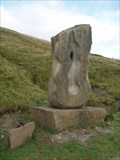
 view gallery view gallery SW11.3 km SW11.3 km
|  Source of the South Tyne - Garrigill, Cumbria, UK Source of the South Tyne - Garrigill, Cumbria, UK
in Abstract Public Sculptures A sculpture by Gilbert Ward at the origin of the River Tyne. It is in the northern Pennines some four miles south of the village of Garrigill.
posted by: Superted location: North West England, United Kingdom date approved: 09/18/2009 last visited: never |
 view gallery view gallerySW11.3 km |  ORIGIN - River South Tyne ORIGIN - River South Tyne
in River Origins, Destinations and Confluences The source of the River South Tyne is in the northern Pennines some four miles south of the village of Garrigill. posted by: Superted location: North East England, United Kingdom date approved: 09/16/2009 last visited: never |
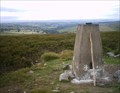 view gallery view galleryNE11.9 km | Bulbeck Common in U.K. and Ireland Trigpoints Pillar trigpoint on Bulbeck Common. posted by: Bambi&Thumper location: United Kingdom date approved: 07/10/2006 last visited: never |
 view gallery view galleryN12.1 km | Watson's Pike in U.K. and Ireland Trigpoints Pillar trigpoint at Watson's Pike. posted by: Bambi&Thumper location: United Kingdom date approved: 06/12/2006 last visited: 09/23/2013 |
 view gallery view galleryW12.6 km | Milestone on B6277 Alston to Middleton in Teesdale in Milestones This milestone is sited at Ashgillhead on the old turnpike road from Alston to Middleton in Teesdale and on to Barnard Castle. posted by: Sir Lose-a-lot location: United Kingdom date approved: 04/21/2008 last visited: 04/16/2008 |
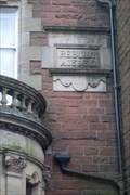
 view gallery view galleryW13.4 km |  Police Station, Front Street, Alston, Essex. Police Station, Front Street, Alston, Essex.
in Ghost Signs A partially blanked out sign above the front door of the Old Police Station betrays the former use of the building. posted by: greysman location: North West England, United Kingdom date approved: 10/15/2012 last visited: never |
 view gallery view galleryW13.4 km | 1GL/PA Bolt, Old Police Station, Front Street, Alston, Cumbria. in U.K. and Ireland Trigpoints On the right-hand pillar of the main front-door of the Old Police Station facing Front Street. posted by: greysman location: North West England, United Kingdom date approved: 09/23/2012 last visited: never |
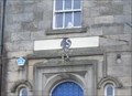
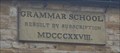 view gallery view galleryW13.5 km |  1828 - The Old Grammar School, Front Street, Alston, Cumbria. 1828 - The Old Grammar School, Front Street, Alston, Cumbria.
in Dated Buildings and Cornerstones Now the Fire Station, this was the Grammar School rebuilt in 1828. posted by: greysman location: North West England, United Kingdom date approved: 10/11/2012 last visited: never |
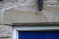 view gallery view galleryW13.5 km | 1732 - Quaker Meeting House, Front Street, Alston, Cumbria. in Dated Buildings and Cornerstones The building date, 1732, is inscribed on the lintel over the porch door. posted by: greysman location: North West England, United Kingdom date approved: 09/24/2012 last visited: never |
 view gallery view galleryW13.5 km | 1898 - Barclays Bank, Front Street, Alston, Cumbria. in Dated Buildings and Cornerstones Formerly the Carlisle and Cumberland Bank it was rebuilt on this site replacing an older 1729 structure. posted by: greysman location: United Kingdom date approved: 10/15/2012 last visited: never |
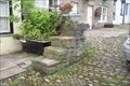 view gallery view galleryW13.5 km |  Mounting Block, Front Street, Alston, Cumbria. Mounting Block, Front Street, Alston, Cumbria.
in Historic Upping Stones, Hitching Posts, and Carriage Blocks A four-step mounting block, the last one in Alston. posted by: greysman location: North West England, United Kingdom date approved: 10/02/2012 last visited: never |
|