 view gallery view gallery NE4.5 km NE4.5 km
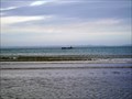
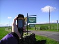
|   Mulberry Harbour Prototype, Rigg Bay, Garlieston, Dumfries and Galloway Mulberry Harbour Prototype, Rigg Bay, Garlieston, Dumfries and Galloway
in World War II Sites Rigg Bay near Garlieston was the proving ground for the most important weapon for the Normandy landings. Mulberry Harbours were tested here. At low tide the remains of one can be seen. The concrete roadway tethering wall has remains visible. posted by:  flipflopnick flipflopnick location: Southern Scotland, United Kingdom date approved: 04/18/2012 last visited: 04/17/2012 |
 view gallery view gallery W10 km W10 km
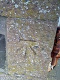
|  Cut Mark - 57 South Street, Port William, Scotland Cut Mark - 57 South Street, Port William, Scotland
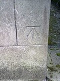
in U.K. and Ireland Trigpoints A cut bench mark on the wall of 57 South Street, Port William. posted by:  Dave_S+Net Dave_S+Net location: Southern Scotland, United Kingdom date approved: 09/29/2011 last visited: never |
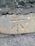 view gallery view galleryW10 km | Cut Mark - Main Street Bridge, Port William, Scotland in U.K. and Ireland Trigpoints A cut bench mark located on the eastern wall of the bridge. posted by: Dave_S+Net location: Southern Scotland, United Kingdom date approved: 09/29/2011 last visited: never |
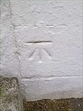 view gallery view galleryW10.1 km | Cut Mark - 12 Main Street, Port William, Scotland in U.K. and Ireland Trigpoints A cut bench mark on the wall of 12 Main Street, Port William. posted by: Dave_S+Net location: Southern Scotland, United Kingdom date approved: 09/29/2011 last visited: never |
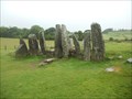 view gallery view galleryNE13.5 km |  Cairn Holy Chambered Cairns - Creetown, Scotland Cairn Holy Chambered Cairns - Creetown, Scotland
in English Heritage - Cadw - Historic Scotland Cairnholy consists of two Neolithic chambered burial cairns of a type characteristic of Galloway. The cairns are located on a hill above Wigtown Bay. The posted coordinates are for Cairnholy I. posted by: Marine Biologist location: Southern Scotland, United Kingdom date approved: 07/22/2012 last visited: never |
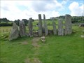 view gallery view galleryNE13.5 km |  Cairnholy - Carsluith, Scotland, UK Cairnholy - Carsluith, Scotland, UK
in Wikipedia Entries Cairnholy (or Cairn Holy), located 4 km east of the village of Carsluith in Dumfries and Galloway, Scotland, is the site of two Neolithic chambered tombs. posted by: Marine Biologist location: Southern Scotland, United Kingdom date approved: 10/04/2017 last visited: never |
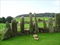 view gallery view galleryNE13.5 km |  Cairn Holy I Chambered Cairn, Dumfries and Galloway Cairn Holy I Chambered Cairn, Dumfries and Galloway
in Megalithic Monuments Cairn Holy I is an ancient place of worship and burial dating back to before 4000BC. Cairn Holy II is nearby. Also known as Cairnholy I. Both managed by Historic Scotland. Open all year. Free. posted by: flipflopnick location: Southern Scotland, United Kingdom date approved: 12/07/2007 last visited: never |
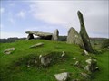 view gallery view galleryNE13.7 km | Cairn Holy II Chambered Cairn, Dumfries and Galloway in Megalithic Monuments A short walk up the track from parking leads to Cairn Holy II, said to be the tomb of the mythical King Galdus. Also known as Cairnholy II. Cairn Holy I is nearby. Both managed by Historic Scotland. Open all year. Free. posted by: flipflopnick location: Southern Scotland, United Kingdom date approved: 12/08/2007 last visited: never |
 view gallery view galleryNE14.3 km |  Mossyard Caravan Park, Dumfries and Galloway, Scotland Mossyard Caravan Park, Dumfries and Galloway, Scotland
in Campgrounds Mossyard camp site is a long way off the main A75 road. Above coords are entrance on A75. Camp ground is on the shore of Wigtown Bay and Irish sea at N 54 50.391 W 004 15.616 Touring field is nearest to beach, as a result furthest from the toilets. posted by: flipflopnick location: Southern Scotland, United Kingdom date approved: 09/18/2006 last visited: never |
 view gallery view gallery NW14.8 km NW14.8 km
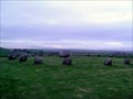
| Torhouse in Wikipedia Entries Torhouse is a stone circle from second millennium BC, beside B733 road between Wigtown and Kirkcowan. Also known as Torhousekie. Managed by Historic Scotland. Open all year. Free access. Parking at site. posted by: flipflopnick location: Southern Scotland, United Kingdom date approved: 12/09/2007 last visited: 08/06/2014 |
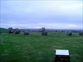 view gallery view galleryNW14.8 km | Torhouse stone circle, Dumfries & Galloway in Megalithic Monuments Torhouse stone circle. At the side of road, in a walled enclosure. Also known as Torhousekie. Managed by Historic Scotland. Open all year. Free. Parking at site. posted by: flipflopnick location: Southern Scotland, United Kingdom date approved: 12/16/2007 last visited: 08/11/2014 |
 view gallery view gallery N16.4 km N16.4 km
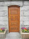
|  Diamond Jubilee Clock Tower Door - Creetown, Scotland Diamond Jubilee Clock Tower Door - Creetown, Scotland
in Doorways of the World The granite clocktower is located at the north end of Creetown in Adamson Square. It was erected in 1897 to mark Queen Victoria's Diamond Jubilee and has a intricately carved door. posted by: Marine Biologist location: Southern Scotland, United Kingdom date approved: 07/23/2012 last visited: 08/06/2014 |
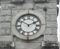 view gallery view galleryN16.4 km |  Diamond Jubilee Clock Tower - Creetown, Scotland Diamond Jubilee Clock Tower - Creetown, Scotland
in Town Clocks The granite clocktower is located at the north end of Creetown in Adamson Square. It was erected in 1897 to mark Queen Victoria's Diamond Jubilee. posted by: Marine Biologist location: Southern Scotland, United Kingdom date approved: 07/22/2012 last visited: 08/06/2014 |
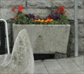 view gallery view galleryN16.4 km |  Diamond Jubilee Clock Tower Horse Troughs - Creetown, Scotland Diamond Jubilee Clock Tower Horse Troughs - Creetown, Scotland
in Historic Upping Stones, Hitching Posts, and Carriage Blocks The granite clocktower is located at the north end of Creetown in Adamson Square. It was erected in 1897 to mark Queen Victoria's Diamond Jubilee and has horse troughs on its north and south sides. posted by: Marine Biologist location: Southern Scotland, United Kingdom date approved: 07/22/2012 last visited: 08/06/2014 |
 view gallery view galleryNE18.3 km |  Cream O' Galloway, Dumfries and Galloway Cream O' Galloway, Dumfries and Galloway
in Ice Cream Parlors Cream O' Galloway is an ice cream connoisseurs destination. Organic ice cream made from their own cows. Sold in their shop and distributed further afield. Facilities available: parking, nature trail, 3D maze and play barn. Cafe and shop. posted by: flipflopnick location: Southern Scotland, United Kingdom date approved: 12/09/2007 last visited: 07/12/2008 |
 view gallery view gallery E19.6 km E19.6 km
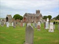
|  Borgue Kirk and Graveyard, Dumfries and Galloway Borgue Kirk and Graveyard, Dumfries and Galloway
in Photos Then and Now The older headstones in the graveyard are much bigger than the modern ones as can be seen from this photograph. Looking north east towards the church from what is now the modern burial plot. posted by: flipflopnick location: Southern Scotland, United Kingdom date approved: 07/21/2008 last visited: never |
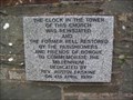 view gallery view galleryE19.6 km |  Borgue Kirk clock and bell, Dumfries and Galloway Borgue Kirk clock and bell, Dumfries and Galloway
in Made for the Millennium Borgue parishioners marked the millennium by reinstating the clock and bell in the church tower. posted by: flipflopnick location: Southern Scotland, United Kingdom date approved: 07/22/2008 last visited: never |
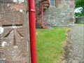 view gallery view galleryE19.6 km | Borgue church PA Bolt with CBM, Dumfries and Galloway in U.K. and Ireland Trigpoints Around the back of Borgue church on a corner is a cut bench mark with lead plug. posted by: flipflopnick location: Southern Scotland, United Kingdom date approved: 07/22/2008 last visited: never |
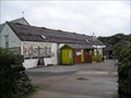
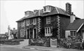 view gallery view galleryE19.8 km | Borgue Hotel, Dumfries & Galloway in Photos Then and Now The Borgue Hotel has been operating for many years. Looking north east across the main road junction. posted by: flipflopnick location: Southern Scotland, United Kingdom date approved: 07/21/2008 last visited: never |
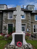 view gallery view galleryE19.8 km |  Borgue War Memorial, Dumfries and Galloway Borgue War Memorial, Dumfries and Galloway
in World War I Memorials and Monuments Borgue War Memorial stands on the lawn in front of the Borgue Hotel on the side of the main road through the village. posted by: flipflopnick location: Southern Scotland, United Kingdom date approved: 07/21/2008 last visited: never |
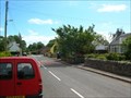
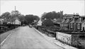 view gallery view galleryE19.8 km | Borgue Main Street, Dumfries and Galloway in Photos Then and Now Borgue is a quiet village which still has a school, hotel and village shop. Looking south down Main Street past the hotel and war memorial and towards the village hall across the junction. posted by: flipflopnick location: Southern Scotland, United Kingdom date approved: 07/21/2008 last visited: never |
 view gallery view galleryE19.8 km | Borgue, Stewartry of Kirkcudbright in Wikipedia Entries Borgue is derived from the Gaelic word burg, which means a little hill, and is certainly very descriptive of the church, which is on the hill near the middle of the village. posted by: flipflopnick location: Southern Scotland, United Kingdom date approved: 07/21/2008 last visited: never |
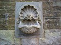 view gallery view galleryNE21.2 km |  Proverbs 12:10 and Psalm 104:10 - Clock Tower - Gatehouse Of Fleet, Dumfries and Galloway, Scotland Proverbs 12:10 and Psalm 104:10 - Clock Tower - Gatehouse Of Fleet, Dumfries and Galloway, Scotland
in Etched in Stone The granite clock tower stands at the north end of High Street in Gatehouse of Fleet. The tower has two water basins. One for people and one for animals both with quotations. posted by: flipflopnick location: Southern Scotland, United Kingdom date approved: 06/22/2010 last visited: never |
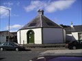 view gallery view galleryN22.2 km |  Newton Stewart Auction Mart Newton Stewart Auction Mart
in Octagon Buildings Newton Stewart has a very old auction mart for livestock and the offices of Craig Wilson Ltd are in an octagonal building. posted by: flipflopnick location: Southern Scotland, United Kingdom date approved: 06/07/2007 last visited: 08/06/2014 |
 view gallery view galleryN22.2 km | Cut Mark - McMillan Hall, Dashwood Square, Newton Stewart, Scotland in U.K. and Ireland Trigpoints A cut benchmark on the Queen Street, east facing wall of McMillan Hall, Newton Stewart. posted by: Dave_S+Net location: Southern Scotland, United Kingdom date approved: 09/29/2011 last visited: 08/06/2014 |
|