 view gallery view gallery W4.8 km W4.8 km
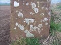
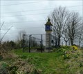
|   CUT BENCH MARK, LANGWATHBY, CUMBRIA CUT BENCH MARK, LANGWATHBY, CUMBRIA
in U.K. and Ireland Trigpoints A cut bench mark in Cumbria. posted by:  plymplodder plymplodder location: United Kingdom date approved: 04/21/2008 last visited: 04/16/2008 |
 view gallery view gallery NW6 km NW6 km
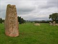
|  Long Meg and her Daughters, Cumbria Long Meg and her Daughters, Cumbria
in Megalithic Monuments Long Meg is a red sandstone pillar outside the ellipse of her daughters, a stone ring. Free to visit. posted by: flipflopnick location: North West England, United Kingdom date approved: 10/10/2008 last visited: 04/28/2023 |
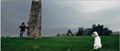 view gallery view galleryNW6 km |  Long Meg & Her Daughters Stone Circle, Little Salkeld, Cumbria, UK – Sightseers (2012) Long Meg & Her Daughters Stone Circle, Little Salkeld, Cumbria, UK – Sightseers (2012)
in Movie Locations Tina’s dog has done a woopsy at the stone circle. She is harangued by a passer by, until Chris disposes of him. posted by: bill&ben location: North West England, United Kingdom date approved: 04/29/2013 last visited: 04/28/2023 |
 view gallery view gallery E6.3 km E6.3 km
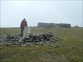
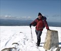
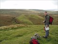
|  Cross Fell Cross Fell
in Mountain Summits Cross Fell (G/NP-001) This is the highest summit in the Pennines. posted by:  charlieg0pzo charlieg0pzo location: United Kingdom date approved: 08/16/2006 last visited: 04/16/2015 |
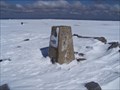 view gallery view galleryE6.3 km | Cross Fell trig point in U.K. and Ireland Trigpoints This Trig point is on highest fell in England outside of the Lake District. posted by: Sir Lose-a-lot location: United Kingdom date approved: 04/23/2008 last visited: 04/16/2015 |
 view gallery view galleryE6.3 km |  Cross Fell trig point Cross Fell trig point
in European Historic Survey Stones, Monuments and Benchmarks This Trig point is on highest fell in England outside of the Lake District. On a good day the views from Cross Fell are fabulous. posted by: Sir Lose-a-lot location: North West England, United Kingdom date approved: 10/09/2010 last visited: 04/16/2015 |
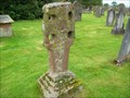 view gallery view galleryNW6.3 km |  Addingham Cross, Cumbria Addingham Cross, Cumbria
in Churchyard Crosses Behind Addingham church is a weathered sandstone Anglo-Saxon cross. posted by: flipflopnick location: North West England, United Kingdom date approved: 10/28/2008 last visited: never |
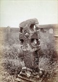 view gallery view galleryNW6.3 km |  Addingham Cross, Cumbria Addingham Cross, Cumbria
in Photos Then and Now Addingham Cross is an Anglo-saxon sandstone cross, of hammer-head design. posted by: flipflopnick location: North West England, United Kingdom date approved: 10/30/2008 last visited: never |
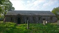
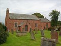 view gallery view galleryNW6.3 km |  Church of St Michael and All Angels, Addingham, Cumbria Church of St Michael and All Angels, Addingham, Cumbria
in This Old Church A church has stood here in the parish of Glassonby since 1272. The current church of St Michael and All Angels is not the original, possibly rebuilt in 1704. posted by: flipflopnick location: North West England, United Kingdom date approved: 11/25/2008 last visited: never |
 view gallery view gallery S6.4 km S6.4 km
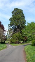
|  Acorn Bank Redwood, Temple Sowerby, Cumbria Acorn Bank Redwood, Temple Sowerby, Cumbria
in Sequoioideae Trees At the turning in to Acorn Bank on a grass island is this magnificent redwood tree. Effectively in the road. posted by: flipflopnick location: North West England, United Kingdom date approved: 05/24/2012 last visited: never |
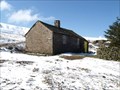 view gallery view galleryE6.6 km |  Greg's Hut, Cross Fell Greg's Hut, Cross Fell
in Remote Backcountry Shelters Greg's Hut is a restored mineshop on the Pennine Way not far below Cross Fell's summit, affording shelter to walkers. posted by: Sir Lose-a-lot location: North West England, United Kingdom date approved: 04/19/2008 last visited: 04/16/2015 |
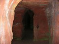
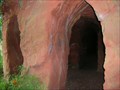 view gallery view galleryNW7.1 km | ") Lacy's caves, River Eden, Cumbria Lacy's caves, River Eden, Cumbria
in Cave Entrances (Artificial) Colonel Lacy paid for these caves to be hollowed out for his guests to enjoy. posted by: flipflopnick location: North West England, United Kingdom date approved: 10/21/2008 last visited: never |
 view gallery view galleryNW7.1 km |  Lacy's Caves Lacy's Caves
in Wikipedia Entries Lacy's Caves are on the east bank of the river Eden, cut out of the red sandstone cliffs. Publicly accessible by well maintained paths through deciduous mature woodlands. Very scenic. posted by: flipflopnick location: North West England, United Kingdom date approved: 10/20/2008 last visited: never |
 view gallery view gallery N7.4 km N7.4 km
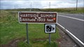
|  Hartside Summit - Cumbria, United Kingdom Hartside Summit - Cumbria, United Kingdom
in Elevation Signs A high point in the Pennines - the "Backbone of England". posted by: Master Mariner location: North West England, United Kingdom date approved: 09/02/2011 last visited: 03/24/2022 |
 view gallery view gallery SW8 km SW8 km
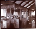
| Ninekirks Church Pews, Cumbria in Photos Then and Now Ninekirks is the colloquial name for St. Ninian's Church. This picture is inside the church showing the wooden stalls with pews and congregation. Looking to the east gable from just inside the main door. posted by: flipflopnick location: North West England, United Kingdom date approved: 05/23/2012 last visited: never |
 view gallery view gallerySW8 km | Ninekirks, Cumbria in Wikipedia Entries Ninekirks is a grade 1 listed church. There has been a religious site here since Roman times. The church is no longer in regular use and in the care of the Church Preservation Trust. Open to the public. posted by: flipflopnick location: North West England, United Kingdom date approved: 05/23/2012 last visited: never |
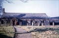 view gallery view gallerySW8 km | Ninekirks Church, Cumbria in Photos Then and Now Ninekirks church is a good photo opportunity as this early colour image shows. Looking north west down the gravel path to the church. Note person in red standing next to the porch. posted by: flipflopnick location: North West England, United Kingdom date approved: 05/23/2012 last visited: never |
 view gallery view galleryE8 km | Little Dun Fell in Mountain Summits Little Dun Fell. This summit lies between Cross Fell and Great Dun Fell on the Pennine Way. posted by: charlieg0pzo location: United Kingdom date approved: 04/29/2007 last visited: 04/16/2015 |
 view gallery view galleryS8 km |  Roman Milestone, Temple Sowerby, Cumbria Roman Milestone, Temple Sowerby, Cumbria
in Milestones This Roman sandstone marker has no markings left on. It is in a lay-by which has been bypassed when the A66 was moved. This milestone is one of only two Roman milestones still in their original positions. Scheduled monument. posted by: flipflopnick location: North West England, United Kingdom date approved: 02/15/2009 last visited: never |
 view gallery view galleryE8.5 km | Bullman Hills - Cumbria, UK in Mountain Summits Bullman Hills only just about qualifies as a mountain being just one foot higher than the definition of a mountain which in England is 2000 feet. posted by: Superted location: North West England, United Kingdom date approved: 09/20/2009 last visited: never |
 view gallery view galleryE8.9 km |  Great Dun Radar Station - Cumbria, UK Great Dun Radar Station - Cumbria, UK
in Geodesic Domes The highest dome in England is an air traffic control station on top of Great Dunn Fell at 2782 feet high. posted by: Superted location: North East England, United Kingdom date approved: 09/30/2009 last visited: 04/11/2020 |
 view gallery view galleryE8.9 km | Great Dun Fell in Mountain Summits Great Dun Fell This is the second highest summit in the pennines. It has a radar installation on the top which is like a giant golf ball. posted by: charlieg0pzo location: United Kingdom date approved: 04/29/2007 last visited: 06/13/2014 |
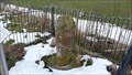
 view gallery view gallerySW9.7 km |  Countess Pillar, A66, Brougham, Cumbria, UK Countess Pillar, A66, Brougham, Cumbria, UK
in UK Historical Markers The Countess Pillar marks the place where Lady Anne Clifford, Countess of Dorset, bade farewell to her mother Margaret on 2 April 1616. posted by: bill&ben location: North West England, United Kingdom date approved: 04/28/2013 last visited: never |
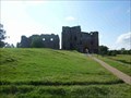 view gallery view gallerySW10.1 km | Brougham Castle, Brougham, Cumbria, England in Wikipedia Entries Brougham Castle, Brougham, Cumbria, England posted by: The_Senior_Crabbes location: North West England, United Kingdom date approved: 08/31/2018 last visited: 03/24/2022 |
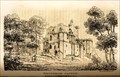 view gallery view gallerySW10.1 km |  Brougham Castle by William Green c 1820 - Brougham Castle, Brougham, Cumbria, UK Brougham Castle by William Green c 1820 - Brougham Castle, Brougham, Cumbria, UK
in Paintings Then and Now An engraving of Brougham Castle by William Green taken from the opposite bank of the river. posted by: bill&ben location: North West England, United Kingdom date approved: 09/08/2013 last visited: 03/24/2022 |
|