 view gallery view gallery N0.8 km N0.8 km
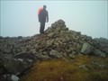
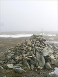
|   High Raise (High Street) High Raise (High Street)
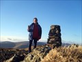
in Mountain Summits High Raise is a fell in the English Lake District, standing to the west of Haweswater Reservoir in the Far Eastern Fells. Note that another High Raise is the highpoint of the Central Fells. posted by:  grufftymilo grufftymilo location: North West England, United Kingdom date approved: 01/25/2011 last visited: 10/26/2012 |
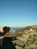
 view gallery view gallery S1.6 km S1.6 km
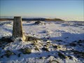
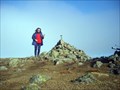
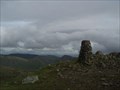
|  High Street Trig Pillar Lake District, Cumbria England High Street Trig Pillar Lake District, Cumbria England
in U.K. and Ireland Trigpoints A classic trig Pillar on High Street in the Lake District. At an altitude of over 820 meter, with fine views across the Lakeland fells. Painted white. posted by:  flipflopnick flipflopnick location: North West England, United Kingdom date approved: 12/21/2006 last visited: 10/20/2011 |
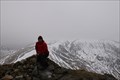
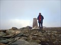 view gallery view galleryS1.6 km | High Street in Mountain Summits High Street (G/LD-011) A Roman Road was built along this summit to take the Legions to Hadrian's Wall, hence the name "High Street" posted by: charlieg0pzo location: United Kingdom date approved: 02/17/2007 last visited: 05/28/2015 |
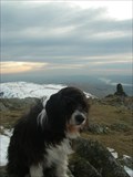
 view gallery view gallery SW3.1 km SW3.1 km
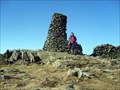
| Thornthwaite Crag in Mountain Summits Thornthwaite Crag This summit lies at the head of the Troutbeck Valley in the Eastern Lake District. posted by: charlieg0pzo location: United Kingdom date approved: 02/17/2007 last visited: 03/17/2016 |
 view gallery view galleryS3.5 km | Harter fell, (Mardale) Cumbria, UK in Mountain Summits Harter Fell at the head of the Kentmere valley,and Mardale, cumbria. posted by: hillhiker1 location: North West England, United Kingdom date approved: 04/20/2010 last visited: 05/28/2015 |
 view gallery view gallerySW3.9 km | Stoney Cove Pike in Mountain Summits Stoney Cove Pike (G/LD-018) This summit is found on the South side of the Kirksone Pass in the Eastern Lake District. posted by: charlieg0pzo location: United Kingdom date approved: 02/17/2007 last visited: 06/10/2013 |
 view gallery view galleryS4.2 km | Froswick in Mountain Summits Froswick 720 m (2,362 ft) posted by: Kitebuggyboy & Ninkle location: North West England, United Kingdom date approved: 04/06/2010 last visited: 01/08/2015 |
 view gallery view gallery W4.5 km W4.5 km
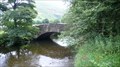
|  Cow Bridge, Hartsop, Cumbria Cow Bridge, Hartsop, Cumbria
in Stone Bridges Cow Bridge is now bypassed by road straightening of A592 with a concrete stone clad modern bridge. Cow Bridge is a classic Lakeland stone bridge. posted by: flipflopnick location: North West England, United Kingdom date approved: 08/13/2010 last visited: 05/22/2017 |
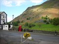
 view gallery view galleryW4.5 km |  Welcome to Hartsop Valley, Cow Bridge, Hartsop, Cumbria Welcome to Hartsop Valley, Cow Bridge, Hartsop, Cumbria
in 'You Are Here' Maps The parking at Cow Bridge is very popular for fellwalkers tackling the fells either side of the valley. This map shows points of interest, although I suspect people know where they are going. posted by: flipflopnick location: North West England, United Kingdom date approved: 08/13/2010 last visited: never |
 view gallery view gallery NW4.8 km NW4.8 km
| Beda Fell. The Lake District,Cumbria England. in Mountain Summits Beda Fell is the long NorthEast ridge of The Angletarn Pikes,often climbed from Martindale but for a really good winter fell walk Deepdale bridge Patterdale is our preferred starting point,a round walk of about 7 miles and 5 hours. posted by: Tashington location: United Kingdom date approved: 12/10/2008 last visited: 05/13/2014 |
 view gallery view galleryS5 km | Yoke- of the Kentmere mountains-Lake District Cumbria England. in Mountain Summits Yoke is the first mountain top summit reached on the Kentmere Horseshoe walk. posted by: Tashington location: United Kingdom date approved: 01/31/2009 last visited: 01/08/2015 |
 view gallery view galleryS5 km | ILL Bell mountain-Lake District,Cumbria England. in Mountain Summits Ill Bell is a mountain in the Kentmere group of Fells,located in the Kentmere valley of The Lake District of Cumbria England. posted by: Tashington location: United Kingdom date approved: 01/31/2009 last visited: 01/08/2015 |
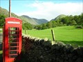 view gallery view galleryW5.1 km |  Classic Red payphone, Deepdale Bridge, Patterdale, Cumbria UK Classic Red payphone, Deepdale Bridge, Patterdale, Cumbria UK
in Payphones A Classic British red K2 kiosk in a charming rural location. Lay-by popular with mountain walkers. No mobile signal due to Cumbrian mountains. On A592 posted by: flipflopnick location: North West England, United Kingdom date approved: 05/29/2006 last visited: 05/24/2017 |
 view gallery view galleryS5.6 km |  Ullstone Gill Footbridge, Kentmere, Cumbria Ullstone Gill Footbridge, Kentmere, Cumbria
in Hiking Path Footbridges Ullstone Gill is the stream that drains the boggy fellside below The Ull Stone, a large erratic boulder. The footbridge gets you across when the gill is flowing strongly. posted by: flipflopnick location: North West England, United Kingdom date approved: 02/10/2008 last visited: 02/11/2008 |
 view gallery view galleryNW6 km | BT red Kiosk, White Lion Hotel, Patterdale, Cumbria UK in Payphones Classic K2 British Red BT payphone kiosk adjacent to White Lion Hotel, Patterdale, Cumbria. In Cumbrian fells where non-existent mobile signal. On A592 road. posted by: flipflopnick location: North West England, United Kingdom date approved: 05/29/2006 last visited: 05/24/2017 |
 view gallery view galleryNW6 km | Place Fell. in Mountain Summits Place Fell stands at the side of Ullswater one of the great lakes of The Lake District of Cumbria England. posted by: fellsmanhiker location: United Kingdom date approved: 10/07/2008 last visited: 03/06/2017 |
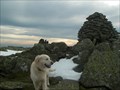
 view gallery view gallery SE6.3 km SE6.3 km
| Tarn Crag in Mountain Summits Tarn Crag (G/LD-026) This is the highest fell to the East of the Longsleddale valley in the Eastern Lake District. It has an interesting tower on the summit, which was used as a survey post during the construction of the Haweswater aguaduct. posted by: charlieg0pzo location: United Kingdom date approved: 12/10/2006 last visited: 08/14/2014 |
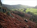
 view gallery view gallerySW6.3 km | Red Screes in Mountain Summits Red Screes (G/LD-017) The whole of the southern face of this summit can be seen from the car park at the top of the Kirkstone Pass. It is a short but strenuous ascent. posted by: charlieg0pzo location: United Kingdom date approved: 02/17/2007 last visited: 07/27/2011 |
 view gallery view gallerySW6.3 km | Red Screes in U.K. and Ireland Trigpoints Red Screes Trigpoint above Ambleside in the Lake District. posted by: theblack location: United Kingdom date approved: 12/11/2007 last visited: 10/14/2013 |
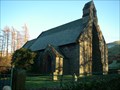
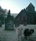 view gallery view galleryNW6.4 km |  St.Patrick's church-Patterdale,Lakedistrict. St.Patrick's church-Patterdale,Lakedistrict.
in This Old Church St.Patrick's church in Patterdale village is one of the finest Victorian churches in the Diocese of Carlisle. posted by: fellsmanhiker location: United Kingdom date approved: 12/31/2008 last visited: 05/24/2017 |
 view gallery view galleryN6.6 km | St.Peter's church-Martindale,Pooley Bridge. in This Old Church The valleys of Martindale are the perfect place for long walks,the church here,makes for a good place to visit on such a walk. posted by: fellsmanhiker location: United Kingdom date approved: 12/06/2008 last visited: 04/19/2013 |
 view gallery view galleryNW6.8 km |  Aira Force Glenamara Park Aira Force Glenamara Park
in National Trust U.K. A trail in Aira Force Glenamara Park near Patterdale. posted by: kallehaugerne location: North West England, United Kingdom date approved: 07/07/2022 last visited: never |
 view gallery view galleryS6.9 km |  Kentmere Kentmere
in Wikipedia Entries Kentmere is an unspoilt valley in the south of Lake District. One of a few valleys without a lake, although there are some man made tarns along the river Kent. Mere means flat stretch of water. posted by: flipflopnick location: North West England, United Kingdom date approved: 02/10/2008 last visited: 04/23/2014 |
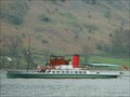 view gallery view galleryNW7.1 km |  Ullswater "Steamer cruises. Ullswater "Steamer cruises.
in Scenic Boat Rides The Boat cruses on Ullswater have been in operation for 150 years.
The sailing is a perfect way of relaxing and enjoying the fabulous mountain scenery. posted by: fellsmanhiker location: United Kingdom date approved: 04/22/2008 last visited: 09/23/2022 |
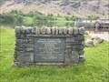 view gallery view galleryNW7.2 km |  Donald Campbell, Water speed record, Ullswater - Glenridding Donald Campbell, Water speed record, Ullswater - Glenridding
in UK Historical Markers This historic signs marks the site where Donalds Campbell broke the record with his boat Blue Bird in 1955 posted by: kallehaugerne location: North West England, United Kingdom date approved: 09/24/2022 last visited: never |
|