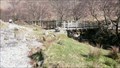
 view gallery view gallery E1.3 km E1.3 km
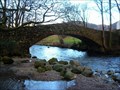
|   Langstrath Beck Lower footbridge, Cumbria Langstrath Beck Lower footbridge, Cumbria
in Hiking Path Footbridges Langstrath is a uninhabited valley in the centre of the Lake District. This bridge is at the western end of the valley. posted by:  flipflopnick flipflopnick location: North West England, United Kingdom date approved: 04/30/2012 last visited: never |
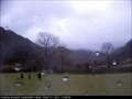 view gallery view gallery N1.3 km N1.3 km
|  Borrowdale School Weather Camera, Cumbria Borrowdale School Weather Camera, Cumbria
in Web Cameras Borrowdale Junior School operate a Weather Cam and recording station. There appears to be water on the lens, permanently. Borrowdale being one of the wettest places in England. Looking south east down Langstrath towards Stonethwaite village. GMT posted by: flipflopnick location: North West England, United Kingdom date approved: 02/01/2011 last visited: never |
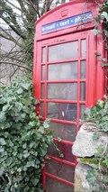 view gallery view galleryN1.4 km |  Stonethwaite Red Telephone kiosk, Cumbria Stonethwaite Red Telephone kiosk, Cumbria
in Red Telephone Boxes There is room for a few cars to park in front of this classic red telephone kiosk in Stonethwaite. posted by: flipflopnick location: North West England, United Kingdom date approved: 05/01/2012 last visited: never |
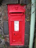 view gallery view galleryN1.8 km |  Longthwaite Post Box, Borrowdale Cumbria Longthwaite Post Box, Borrowdale Cumbria
in Victorian Post Boxes Longthwaite Post Box in the Borrowdale valley, south of Keswick. A road side box mounted in the garden wall between house and bus shelter. posted by: flipflopnick location: North West England, United Kingdom date approved: 11/21/2007 last visited: never |
 view gallery view galleryN1.9 km |  Longthwaite Bridge, Borrowdale, Keswick Longthwaite Bridge, Borrowdale, Keswick
in Stone Bridges Access to the farm and Youth Hostel is over Longthwaite bridge, an arched stone bridge across the river Derwent. posted by: flipflopnick location: North West England, United Kingdom date approved: 01/07/2008 last visited: never |
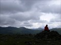
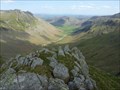
 view gallery view gallery SW2.3 km SW2.3 km
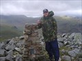
|  Glaramara Glaramara
in Mountain Summits Glaramara is a fell in the English Lake District in Cumbria posted by:  grufftymilo grufftymilo location: North West England, United Kingdom date approved: 03/21/2011 last visited: 10/28/2014 |
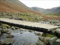
 view gallery view gallerySW2.9 km | Stockley Bridge, Borrowdale, Cumbria in Stone Bridges Stockley bridge is an old packhorse route to carry goods between Borrowdale and West coast. Nowadays used by walkers heading for the high fells. posted by: flipflopnick location: North West England, United Kingdom date approved: 04/26/2008 last visited: 04/18/2015 |
 view gallery view gallery NW3.2 km NW3.2 km
| Tongue Gill footbridges, Borrowdale, Keswick in Hiking Path Footbridges The Allerdale Ramble crosses Tongue Gill using these two wooden footbridges. A popular path going behind Castle Crag. posted by: flipflopnick location: North West England, United Kingdom date approved: 01/07/2008 last visited: 10/31/2008 |
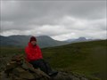
 view gallery view galleryE3.2 km |  Ullscarf, Cumbria Ullscarf, Cumbria
in Scenic Overlooks Ullscarf is a highpoint on the broad ridge between Thirlmere and Borrowdale. The view is extensive in all directions. posted by: flipflopnick location: North West England, United Kingdom date approved: 05/05/2011 last visited: 06/04/2014 |
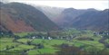 view gallery view galleryN3.4 km |  Rosthwaite, Lake District Rosthwaite, Lake District
in Picture Perfect Postcards A cold and clear winter's morning of Rosthwaite village in Borrowdale from part way up Castle Crag. posted by: flipflopnick location: North West England, United Kingdom date approved: 02/07/2008 last visited: 06/25/2014 |
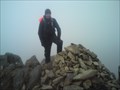
 view gallery view gallery W3.5 km W3.5 km
| Base Brown in Mountain Summits Base Brown 646m (2,120ft) asl posted by: Kitebuggyboy & Ninkle location: North West England, United Kingdom date approved: 05/25/2009 last visited: 06/25/2014 |
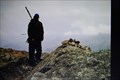
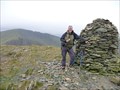
 view gallery view gallery SE3.7 km SE3.7 km
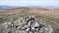
|  High Raise High Raise
in U.K. and Ireland Trigpoints High Raise Trigpoint in the Lake District. posted by: theblack location: United Kingdom date approved: 12/11/2007 last visited: 04/29/2014 |
 view gallery view galleryN3.7 km |  Castle Crag memorial, Borrowdale, Keswick Castle Crag memorial, Borrowdale, Keswick
in World War I Memorials and Monuments On the summit of Castle Crag in Borrowdale is a memorial plaque to the Borrowdale men who fell in the Great War. posted by: flipflopnick location: North West England, United Kingdom date approved: 01/10/2008 last visited: 10/14/2014 |
 view gallery view gallerySE3.7 km | High Raise in Mountain Summits High Raise (G/LD-019) This summit is the highest of the Langdales and is the most centrally situated summit in the Lake District. posted by: charlieg0pzo location: United Kingdom date approved: 05/24/2007 last visited: 12/28/2014 |
 view gallery view galleryW4 km | Grey Knotts in Mountain Summits Grey Knotts (2287ft asl) posted by: charlieg0pzo location: United Kingdom date approved: 04/15/2009 last visited: 10/25/2014 |
 view gallery view galleryW4.3 km | Brandreth in Mountain Summits Brandreth (2344ft asl) posted by: charlieg0pzo location: United Kingdom date approved: 04/15/2009 last visited: 10/25/2014 |
 view gallery view gallerySW4.5 km | Allen Crags in Mountain Summits Allen Crags is a fell in the English Lake District, it lies in a group of very popular hills and is regarded as part of the Scafell group of fells. It is a hill that is frequently traversed by walkers along its ridge but is seldom climbed as the sole objective. posted by: grufftymilo location: North West England, United Kingdom date approved: 01/27/2011 last visited: 04/30/2014 |
 view gallery view gallerySE4.5 km | Sergeant Man in Mountain Summits Sergeant Man 736 m (2414 ft) posted by: Kitebuggyboy & Ninkle location: North West England, United Kingdom date approved: 06/08/2009 last visited: 12/28/2014 |
 view gallery view galleryNW4.5 km | High Spy, Lake District, Cumbria, UK in Mountain Summits High Spy, Cumbria, UK. posted by: The Barrower location: United Kingdom date approved: 10/21/2009 last visited: 09/29/2014 |
 view gallery view galleryNW4.5 km | Dale Head in Mountain Summits Dale Head (G/LD-020) This summit lies at the head of the Newlands Valley in the Lake District. It has a very fine summit cairn. posted by: charlieg0pzo location: United Kingdom date approved: 01/07/2007 last visited: 05/03/2014 |
 view gallery view galleryW4.7 km | Green Gable in Mountain Summits Green Gable (2603ft asl) posted by: charlieg0pzo location: United Kingdom date approved: 04/17/2009 last visited: 06/25/2014 |
 view gallery view gallerySE4.8 km | Thunacar Knott in Mountain Summits Thunacar Knott 723 m (2,372 ft) posted by: Kitebuggyboy & Ninkle location: North West England, United Kingdom date approved: 06/08/2009 last visited: 04/29/2014 |
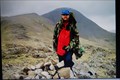
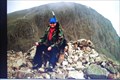
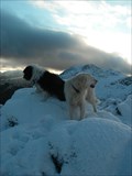
 view gallery view gallery S5 km S5 km
|  Rossett Pike, Langdale, Lake district, UK Rossett Pike, Langdale, Lake district, UK
in Summit Registers Rossett pike, with wonderful views down Mickleden posted by: hillhiker1 location: North West England, United Kingdom date approved: 05/18/2011 last visited: 04/30/2014 |
 view gallery view galleryS5 km | Stake Gill, Mickleden, Langdale, Cumbria in Hiking Path Footbridges A useful crossing point over Stake Gill at the head of Mickleden. Used by many fell walkers each day. posted by: flipflopnick location: North West England, United Kingdom date approved: 11/25/2007 last visited: 10/17/2009 |
 view gallery view gallerySE5.1 km | Pavey Ark.The Langdale Pikes,Lake District Cumbria England in Mountain Summits The wonderfully named Pavey Ark mountain,one of the Langdale Fells has the biggest and most dramatic crag in the Lake District. posted by: Tashington location: United Kingdom date approved: 12/14/2008 last visited: 04/29/2014 |
|