 view gallery view gallery E2.7 km E2.7 km
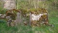
|   Crosby Garrett Pinfold, Cumbria Crosby Garrett Pinfold, Cumbria
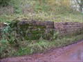
in Town and Village Pounds This a small pound on the outskirts of Crosby Garrett. On the road leading up to the common grazing of Nettle Hill. Just south of the viaduct. posted by:  flipflopnick flipflopnick location: North West England, United Kingdom date approved: 05/13/2012 last visited: never |
 view gallery view gallery SE3.1 km SE3.1 km
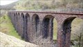
|  Smardale Gill Viaduct - Cumbria, UK Smardale Gill Viaduct - Cumbria, UK
in Railroad Bridges Smardale Gill Viaduct was the original structure which the Northern Viaduct Trust took in to its care. A disused rail bridge, high over the beck, carrying the former "Stainmore Line". Open for everyone to use. posted by: flipflopnick location: North West England, United Kingdom date approved: 05/10/2012 last visited: never |
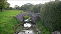
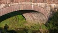
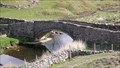 view gallery view gallerySE3.2 km |  Smardale Bridge, Cumbria Smardale Bridge, Cumbria
in Stone Bridges Smardale Bridge is an old pack horse bridge which has been widened to carry wheeled carts. Now crossed by walkers on the coast to Coast (C2C) long distance path. Grade 2 listed structure. posted by: flipflopnick location: North West England, United Kingdom date approved: 05/10/2012 last visited: never |
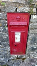 view gallery view gallerySE4.5 km |  Mill Street VR Postbox, Ravenstonedale, Cumbria Mill Street VR Postbox, Ravenstonedale, Cumbria
in Victorian Post Boxes This Victorian postbox is in the wall of Coldbeck House garden, on Mill Street, Ravenstonedale. posted by: flipflopnick location: North West England, United Kingdom date approved: 06/20/2012 last visited: never |
 view gallery view galleryE4.8 km |  Waitby Railway Bridge Flush Bracket 1244, Cumbria Waitby Railway Bridge Flush Bracket 1244, Cumbria
in U.K. and Ireland Trigpoints The disused railway bridge has disappeared leaving the roadside walls with this flush bracket, 1244, placed during the second geodetic levelling (1912-21). Possibly before 1913. posted by: flipflopnick location: North West England, United Kingdom date approved: 12/17/2008 last visited: never |
 view gallery view gallery NE5 km NE5 km
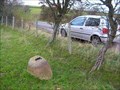
| Codgy Bank OSBM Bolt, near Kirkby Stephen, Cumbria in U.K. and Ireland Trigpoints An OSBM bolt stuck in the top of an obvious boulder 2 metre into the field from the hedge. Easily visible from the road. posted by: flipflopnick location: North West England, United Kingdom date approved: 12/15/2008 last visited: never |
 view gallery view gallery NW5 km NW5 km
|  Packhorse Bridge, Great Asby, Cumbria Packhorse Bridge, Great Asby, Cumbria
in Hiking Path Footbridges This lovely old packhorse bridge is a crossing point for the long distance walkers on the Westmorland Way. They cross Dale Beck to bypass the village. posted by: flipflopnick location: North West England, United Kingdom date approved: 08/26/2011 last visited: never |
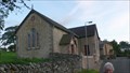
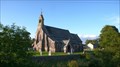
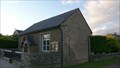
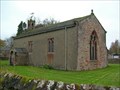
 view gallery view galleryNW5 km |  Great Asby Baptist Church, Cumbria Great Asby Baptist Church, Cumbria
in This Old Church The baptist chapel in Great Asby opened in 1862. posted by: flipflopnick location: North West England, United Kingdom date approved: 08/25/2011 last visited: never |
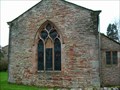
 view gallery view galleryNW5 km |  Great Asby Baptist Church - Great Asby, Cumbria, England, UK Great Asby Baptist Church - Great Asby, Cumbria, England, UK
in Baptist Churches This Baptist chapel is not the only church in Great Asby. There are three churches and they share services on rotation. posted by: flipflopnick location: North West England, United Kingdom date approved: 08/25/2011 last visited: never |
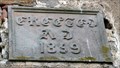
 view gallery view galleryNW5 km |  1862 - Great Asby Baptist Church, Cumbria 1862 - Great Asby Baptist Church, Cumbria
in Dated Buildings and Cornerstones The baptist chapel in Great Asby was built in 1862. Walk upstream on south bank of stream. posted by: flipflopnick location: North West England, United Kingdom date approved: 08/25/2011 last visited: never |
 view gallery view galleryNW5.1 km |  Mounting Block, Three Greyhounds pub, Great Asby Mounting Block, Three Greyhounds pub, Great Asby
in Historic Upping Stones, Hitching Posts, and Carriage Blocks This mounting block is outside the village pub, The Three Greyhounds in Great Asby. The pub name probably comes from the coat of arms of the ancient lord of the manor. posted by: flipflopnick location: North West England, United Kingdom date approved: 08/24/2011 last visited: never |
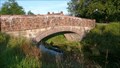 view gallery view galleryNW5.1 km | Patrick's Bridge, Great Asby, Cumbria in Stone Bridges The main road bridge in the centre of Great Asby is called Patrick's Bridge named after the benefactor. Thje bridge has always been called Patrick's. Not known why. posted by: flipflopnick location: North West England, United Kingdom date approved: 08/23/2011 last visited: never |
 view gallery view galleryNW5.1 km |  Patrick's Bridge, Great Asby, Cumbria Patrick's Bridge, Great Asby, Cumbria
in Arch Bridges Patrick's Bridge is the name of the main crossing of Dale Beck in Great Asby. Patrick was the benefactor, but that is all that is known. posted by: flipflopnick location: North West England, United Kingdom date approved: 08/23/2011 last visited: never |
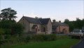
 view gallery view galleryNW5.1 km | St Peter's Church, Great Asby, Cumbria in This Old Church St Peter's Church stands in the middle of Great Asby. A church has stood on this site since 1160. posted by: flipflopnick location: North West England, United Kingdom date approved: 08/23/2011 last visited: never |
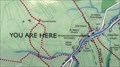 view gallery view galleryNW5.1 km |  Area Map, Bus shelter, Great Asby, Cumbria Area Map, Bus shelter, Great Asby, Cumbria
in 'You Are Here' Maps This map is attached to the north side of the new bus passenger shelter in Great Asby. The map describes the paths around Great Asby. posted by: flipflopnick location: North West England, United Kingdom date approved: 08/26/2011 last visited: never |
 view gallery view galleryNW5.1 km | 1900 - Bridge End House, Great Asby, Cumbria in Dated Buildings and Cornerstones Bridge End House is on north side of Patrick's Bridge in the centre of Great Asby. posted by: flipflopnick location: North West England, United Kingdom date approved: 08/26/2011 last visited: never |
 view gallery view gallery N5.1 km N5.1 km
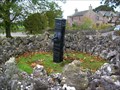
|  St. Helen's well, Great Asby, Cumbria St. Helen's well, Great Asby, Cumbria
in Holy Wells St. Helen's well is on the village green near the church, in the centre of the village of Great Asby. posted by: flipflopnick location: North West England, United Kingdom date approved: 08/23/2011 last visited: never |
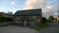
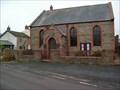
 view gallery view galleryN5.3 km | Great Asby Methodist Church, Cumbria in This Old Church This Methodist chapel is at the north end of the village of Great Asby. posted by: flipflopnick location: North West England, United Kingdom date approved: 08/25/2011 last visited: never |
 view gallery view galleryN5.3 km |  Great Asby Methodist Church, Cumbria Great Asby Methodist Church, Cumbria
in Methodist Churches This Methodist chapel is one of three places of worship in Great Asby, which share their Sunday services, on rotation. posted by: flipflopnick location: North West England, United Kingdom date approved: 08/25/2011 last visited: never |
 view gallery view galleryN5.3 km | 1859 - Great Asby Methodist Church, Cumbria in Dated Buildings and Cornerstones The Methodist chapel in Great Asby was built in 1859. Walk downstream on south bank from centre of the village. posted by: flipflopnick location: North West England, United Kingdom date approved: 08/25/2011 last visited: never |
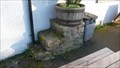
 view gallery view galleryNE5.5 km |  Soulby Jubilee Pump, Cumbria Soulby Jubilee Pump, Cumbria
in Hand Operated Water Pumps The parishioners of Soulby have a wall around their village pump which has a plaque on the wooden covering box. posted by: flipflopnick location: North West England, United Kingdom date approved: 10/24/2010 last visited: never |
 view gallery view galleryNE5.5 km | St Luke's Church, Soulby, Cumbria in This Old Church St Luke's church stands in the middle of the village looking across at the Wesleyan Chapel. The church is set in its own small churchyard. There is now a 1.5 metre high wall round the island of grass surrounded by village roads. posted by: flipflopnick location: North West England, United Kingdom date approved: 12/18/2008 last visited: never |
 view gallery view galleryNE5.5 km | Soulby Church Cut Mark, Cumbria in U.K. and Ireland Trigpoints This mark is etched into the corner stone of the east face of St Luke's church, Soulby. This is the only face which has not been rendered. posted by: flipflopnick location: North West England, United Kingdom date approved: 12/18/2008 last visited: never |
 view gallery view galleryNE5.5 km | Soulby Methodist Church, Cumbria in This Old Church Soulby Methodist church stands in the middle of the village, looking down toward the bridge and old ford. posted by: flipflopnick location: North West England, United Kingdom date approved: 12/18/2008 last visited: never |
 view gallery view galleryNE5.5 km | Soulby Methodist Church Flush Bracket 1245, Cumbria in U.K. and Ireland Trigpoints Soulby Methodist Church is made of sandstone creating an easy material to embed the flush bracket, 1245, in. Without a preceding G nor S suggests this was an early flush bracket, placed in the second geodetic levelling (1912-21). posted by: flipflopnick location: North West England, United Kingdom date approved: 12/17/2008 last visited: never |
|