 view gallery view gallery N5 km N5 km
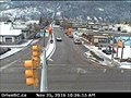
|   Terrace Traffic Webcam - Terrace, BC Terrace Traffic Webcam - Terrace, BC
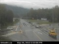
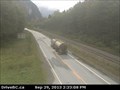
in Web Cameras Hwy 16 at Hwy 37 just east of Terrace across the Skeena River, looking east on Hwy 16. posted by:  T0SHEA T0SHEA location: British Columbia, Canada date approved: 10/04/2013 last visited: 01/14/2014 |
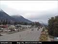
 view gallery view gallery S19.5 km S19.5 km
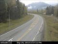
| Onion Lake Traffic Webcam - Kitimat, BC in Web Cameras West side of Hwy 37 South at Onion Lake Cross Country ski trails, 28 km. south on Hiway 37 from Terrace. posted by: T0SHEA location: British Columbia, Canada date approved: 10/04/2013 last visited: 01/14/2014 |
 view gallery view gallery NE24.5 km NE24.5 km
| Chimdemash Creek Webcam - Terrace, BC in Web Cameras A new BC Highways webcam, this is about 22 kilometres up Highway from Terrace. posted by: T0SHEA location: British Columbia, Canada date approved: 12/02/2016 last visited: never |
 view gallery view galleryS41.5 km | Kitimat Traffic Webcam - Kitimat, BC in Web Cameras Hwy 37 at Oolichan Avenue, 5 km north of Kitimat. Kitimat is where a zillion tons of aluminum have been produced, beginning in the 1950s. posted by: T0SHEA location: British Columbia, Canada date approved: 10/04/2013 last visited: 01/14/2014 |
 view gallery view gallery W52.9 km W52.9 km
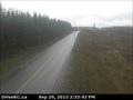
| Kasiks Traffic Webcam - Terrace, BC in Web Cameras Hwy 16, at Kasiks resort area, 60 km west of Terrace. This is close to mid way between Terrace and Prince Rupert. posted by: T0SHEA location: British Columbia, Canada date approved: 10/04/2013 last visited: 01/14/2014 |
 view gallery view galleryNE76.8 km | Kitwanga Traffic Webcam - Kitwanga, BC in Web Cameras Junction of Hwy 16 and Hwy 37, near Kitwanga, looking west on Hwy 16. This place sounds like it should be in Australia. posted by: T0SHEA location: British Columbia, Canada date approved: 10/04/2013 last visited: 01/14/2014 |
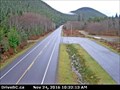 view gallery view galleryW95.4 km | Rainbow Summit Traffic Webcam - Prince Rupert, BC in Web Cameras This camera is on Highway 16 at what is known as Rainbow Summit, about 31 kilometres southeast of Prince Rupert. posted by: T0SHEA location: British Columbia, Canada date approved: 12/02/2016 last visited: never |
 view gallery view galleryNE96.1 km | Hiway 16 at Trout Creek Traffic Webcam - Smithers, BC in Web Cameras Hiway 16 at the Trout Creek bridge, about 20 km. northwest of Smithers. What are the odds that this is a good place to get one's flies wet, or for drowning worms? posted by: T0SHEA location: British Columbia, Canada date approved: 10/04/2013 last visited: 01/14/2014 |
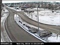
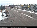
 view gallery view gallery E97.4 km E97.4 km
| Smithers South Traffic Webcam - Smithers, BC in Web Cameras This is one of four cameras in a pod in the town of Smithers on Hiway 16 at Main Street. posted by: T0SHEA location: British Columbia, Canada date approved: 12/02/2016 last visited: never |
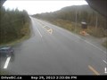
 view gallery view galleryE97.4 km | Smithers Traffic Webcam - Smithers, BC in Web Cameras In the town of Smithers on Hiway 16 at Main Street, looking west. Pretty much self explanatory. posted by: T0SHEA location: British Columbia, Canada date approved: 10/04/2013 last visited: 01/14/2014 |
 view gallery view galleryE97.4 km | Smithers North Traffic Webcam - Smithers, BC in Web Cameras This is one of four cameras in a pod in the town of Smithers on Hiway 16 at Main Street. posted by: T0SHEA location: British Columbia, Canada date approved: 12/02/2016 last visited: never |
 view gallery view galleryE97.4 km | Smithers East Traffic Webcam - Smithers, BC in Web Cameras This is one of four cameras in a pod in the town of Smithers on Hiway 16 at Main Street. posted by: T0SHEA location: British Columbia, Canada date approved: 12/02/2016 last visited: never |
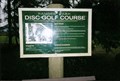 view gallery view galleryE98.2 km |  Ranger Park Disk Golf Course - Smithers, BC Ranger Park Disk Golf Course - Smithers, BC
in Disc Golf Courses This is the most northern course in British Columbia. posted by:  Hippie Kidz Hippie Kidz location: British Columbia, Canada date approved: 03/26/2009 last visited: never |
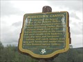 view gallery view galleryNE100.4 km |  Moricetown Canyon - Moricetown, BC Moricetown Canyon - Moricetown, BC
in British Columbia Heritage Markers This marker about the Moricetown Canyon is located along the Trans-Canada Yellowhead Highway 16 near Moricetown, British Columbia. posted by: Marine Biologist location: British Columbia, Canada date approved: 08/07/2013 last visited: 03/02/2023 |
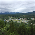 view gallery view galleryNE107 km |  Lookout Trail - New Hazelton, BC, Canada Lookout Trail - New Hazelton, BC, Canada
in Scenic Overlooks Top of a hiking trail overlooking the Village of New Hazelton posted by: redon73 location: British Columbia, Canada date approved: 07/05/2016 last visited: 07/05/2016 |
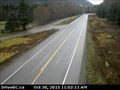
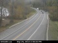
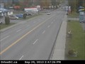 view gallery view galleryNE107.3 km | New Hazelton Traffic Webcam - New Hazelton. BC in Web Cameras On Hiway 16 at McLeod Street in New Hazelton. posted by: T0SHEA location: British Columbia, Canada date approved: 10/04/2013 last visited: 01/14/2014 |
|