 view gallery view gallery W0.3 km W0.3 km
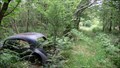
|   Morris Minor in Nichols Wood, Cumbia Morris Minor in Nichols Wood, Cumbia
in Abandoned Dead Vehicles A Morris Minor decaying into the birch scrub on the edge of Nichols Wood. posted by:  flipflopnick flipflopnick location: North West England, United Kingdom date approved: 06/11/2009 last visited: never |
 view gallery view gallery SW1.4 km SW1.4 km
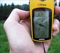
|  Lindale Cumbria Palindrome - Lindale, UK Lindale Cumbria Palindrome - Lindale, UK
in Coordinate Palindromes Near Lindale village, in a field, on a public footpath, under the power lines. With or without the double zero in front of westing, its still a palindrome. posted by: flipflopnick location: North West England, United Kingdom date approved: 08/31/2006 last visited: never |
 view gallery view gallery NW1.4 km NW1.4 km
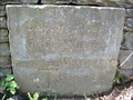
|  Lancashire and Westmorland County Boundary at Bleacrag Bridge, Cumbria Lancashire and Westmorland County Boundary at Bleacrag Bridge, Cumbria
in Border Crossings The river Winster used to be the old county boundary between Lancashire and Westmorland. Here the boundary is marked on a very fine inscribed stone laid into the Bleacrag bridge. posted by: flipflopnick location: North West England, United Kingdom date approved: 04/04/2008 last visited: never |
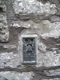
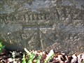 view gallery view galleryNW1.4 km |  Bleacrag Bridge Cut Mark, Cumbria Bleacrag Bridge Cut Mark, Cumbria
in U.K. and Ireland Trigpoints Bleacrag bridge is on the old county boundary between Lancashire and Westmorland. The OS look to have over written the old inscription with their chiselling. posted by: flipflopnick location: North West England, United Kingdom date approved: 04/03/2008 last visited: never |
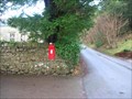 view gallery view gallery N1.6 km N1.6 km
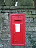
|  Witherslack VR post box, Cumbria Witherslack VR post box, Cumbria
in Victorian Post Boxes Near the church on the road through Witherslack is this Victorian post box built into the corner wall. posted by: flipflopnick location: North West England, United Kingdom date approved: 01/15/2008 last visited: never |
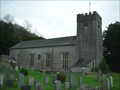 view gallery view galleryN1.6 km |  St. Paul's Church - Witherslack. St. Paul's Church - Witherslack.
in This Old Church St.Paul's church at Witherslack was built under the will of John Barwick, Dean of Durham and St.Paul's cathedral. posted by:  fellsmanhiker fellsmanhiker location: United Kingdom date approved: 11/22/2008 last visited: 11/28/2008 |
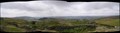 view gallery view galleryW2.4 km |  Newton Fell, South Cumbria Newton Fell, South Cumbria
in Scenic Overlooks Newton Fell is a high point on a ridge running alongside the main road, A590, across the south of county. Prominent above High Newton village. posted by: flipflopnick location: North West England, United Kingdom date approved: 08/06/2006 last visited: 02/18/2008 |
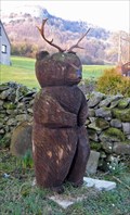 view gallery view gallery NE2.4 km NE2.4 km
|  Antler bear - Witherslack, Cumbria UK Antler bear - Witherslack, Cumbria UK
in Outside Wooden Display Carvings At a house called Sunny Hollow in the village of Witherslack stands this carved bear. Other animals are also in the garden and it looks like the maker lives here - big logs are waiting to be converted into sculptures. posted by: martlakes location: United Kingdom date approved: 02/19/2008 last visited: never |
 view gallery view gallery S2.4 km S2.4 km
| Meathop Grange: Grange-over-Sands, Cumbria UK in Victorian Post Boxes Wall mounted box at the entrance to Meathop Grange, just outside Grange-over-Sands. In good nick. posted by: martlakes location: United Kingdom date approved: 02/15/2008 last visited: 03/08/2008 |
 view gallery view gallerySW2.4 km | Moss End Farm Flush Bracket G2823, Low Newton, Cumbria in U.K. and Ireland Trigpoints This flush bracket is low down on the facing wall of the main farmhouse, as you walk down into the farmyard. The walls have been rendered leaving this plate exposed, fortunately. posted by: flipflopnick location: North West England, United Kingdom date approved: 02/01/2009 last visited: never |
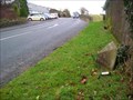 view gallery view gallerySW2.6 km |  Lindale Milestone, Cumbria Lindale Milestone, Cumbria
in Milestones This milestone is half buried in the grass verge, under a rough cast wall. This road is still the main road in to Cartmel Peninsular from the east. posted by: flipflopnick location: North West England, United Kingdom date approved: 02/08/2008 last visited: 03/14/2008 |
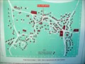 view gallery view gallerySW2.6 km |  Lindale Village Map, Cumbria Lindale Village Map, Cumbria
in 'You Are Here' Maps Lindale has a diagrammatic plan showing approximate position of houses. Drawn up in 2000, as a millennium project. posted by: flipflopnick location: North West England, United Kingdom date approved: 01/10/2008 last visited: 03/14/2008 |
 view gallery view gallerySW2.6 km | Mason's House Flush Bracket, Lindale, Cumbria in U.K. and Ireland Trigpoints Mason's House is on a junction on south side of road through Lindale. Millennium garden opposite. Coords are white line in middle of road junction as poor signal. posted by: flipflopnick location: North West England, United Kingdom date approved: 10/17/2006 last visited: 10/17/2006 |
 view gallery view gallerySW2.6 km | Wooden Mushrooms, Lindale Millennium Garden, Cumbria in Outside Wooden Display Carvings Wooden Mushrooms growing in the gravel of the Millennium Garden in Lindale. Slow down as you drive through middle of village. posted by: flipflopnick location: North West England, United Kingdom date approved: 10/17/2006 last visited: 03/14/2008 |
 view gallery view galleryW2.6 km | Low Newton Farm Cut Mark, Cumbria in U.K. and Ireland Trigpoints A fading cut mark on the left side of large door surround of the farm buildings on the east side of the old A590 road. posted by: flipflopnick location: North West England, United Kingdom date approved: 02/01/2009 last visited: never |
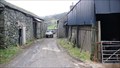
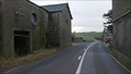
 view gallery view galleryW2.6 km |  1848 - Low Newton Farm, Cumbria 1848 - Low Newton Farm, Cumbria
in Dated Buildings and Cornerstones The main A590 trunk road ran through the farmyard of Low Newton farm until the bypass opened in 2008. Now the road is much quieter but still splits the farm apart. posted by: flipflopnick location: North West England, United Kingdom date approved: 02/02/2009 last visited: never |
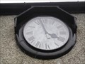 view gallery view gallerySW2.6 km |  Village Hall Clock, Lindale, Cumbria Village Hall Clock, Lindale, Cumbria
in Town Clocks Lindale Village Hall is still in use for village events. Clock mounted under roof line, with Roman numeral digits. posted by: flipflopnick location: North West England, United Kingdom date approved: 10/17/2006 last visited: 03/14/2008 |
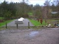
 view gallery view gallerySW2.6 km |  Village Hall Car Park - Lindale, Cumbria UK Village Hall Car Park - Lindale, Cumbria UK
in Unusual Signs It's a car park for the village hall, but make sure you don't park a car there! posted by: martlakes location: United Kingdom date approved: 03/15/2008 last visited: never |
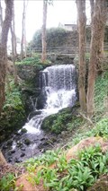 view gallery view gallerySW2.6 km |  The Weir - Lindale The Weir - Lindale
in Man-made Waterfalls The Weir is the local name for the obstruction in Lindale Beck to feed the mill pond, now gone. posted by: flipflopnick location: North West England, United Kingdom date approved: 04/05/2016 last visited: never |
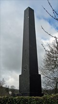 view gallery view gallerySW2.6 km |  Iron Mad Wilkinson Obelisk - Lindale, Cumbria UK Iron Mad Wilkinson Obelisk - Lindale, Cumbria UK
in Relocated Structures John 'Iron Mad' Wilkinson was an industrialist and innovator whose methods produced iron in abundance. He found numerous new applications for iron and was buried in an iron coffin under a mighty iron obelisk. Not where it now stands though. posted by: martlakes location: North West England, United Kingdom date approved: 03/15/2008 last visited: 03/16/2008 |
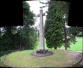
 view gallery view gallerySW2.6 km |  John Wilkinson Memorial, Lindale, Cumbria John Wilkinson Memorial, Lindale, Cumbria
in Obelisks John "Iron-Mad" Wilkinson had a cast iron obelisk erected over his grave, initially in the grounds of his house at Castlehead. But that is not where the obelisk now stands. Read on for its strange tale. posted by: flipflopnick location: North West England, United Kingdom date approved: 06/11/2007 last visited: 07/19/2008 |
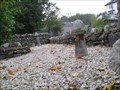
 view gallery view gallerySW2.6 km |  The Mill pond sluice - Lindale The Mill pond sluice - Lindale
in Historic Hand Operated Sluice Gates There used to be a mill in Lindale, fed by a mill pond. Both now gone. This sluice and a brick pillar remain. Water from the beck was fed into the pond via this sluice. posted by: flipflopnick location: North West England, United Kingdom date approved: 04/05/2016 last visited: never |
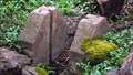
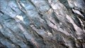 view gallery view gallerySW2.6 km |  Ripple Rocks, Lindale, Cumbria Ripple Rocks, Lindale, Cumbria
in Places of Geologic Significance The Ripple Rocks are beside the road through Lindale, on the north side of the road, facing east, at the entrance of a short uphill track. posted by: flipflopnick location: North West England, United Kingdom date approved: 01/14/2011 last visited: never |
 view gallery view gallerySW2.7 km |  Lindale Skate ramps, Cumbria Lindale Skate ramps, Cumbria
in Skateparks Lindale has a small skate area between the main road and the recreation field. posted by: flipflopnick location: North West England, United Kingdom date approved: 02/28/2008 last visited: 03/14/2008 |
 view gallery view gallerySW2.7 km |  Lindale World War Memorial Cumbria Lindale World War Memorial Cumbria
in World War I Memorials and Monuments Lindale's memorial is near the new (2006) bowling green next to church yard. Visible from road B5271 through top of Lindale village. On a mound, set in own fenced area, which is a well maintained. Views East are very good. posted by: flipflopnick location: North West England, United Kingdom date approved: 08/18/2006 last visited: 02/17/2008 |
|