 view gallery view gallery SW1.6 km SW1.6 km
|  ") Gaping Gill, North Yorkshire Gaping Gill, North Yorkshire
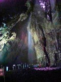
in Cave Entrances (Natural) Gaping Gill is where Fell Beck drops 105 meter underground into a massive chamber. Normally unseen this spectacular void is only available to dedicated potholers. For 2 weeks a year a winched chair lowers waymarkers to the chamber floor for a fee. posted by:  flipflopnick flipflopnick location: Yorkshire, United Kingdom date approved: 05/28/2008 last visited: 09/03/2014 |
 view gallery view gallerySW1.6 km |  Gaping Gill Gaping Gill
in Wikipedia Entries Gaping Gill is an impressive pothole on the lower flanks of Ingleborough fell. Fell Beck cascades over 100 meters down through entrance hole to an impressive chamber below. Free to visit. Pothole clubs operate public access winches twice a year. posted by: flipflopnick location: Yorkshire, United Kingdom date approved: 05/27/2008 last visited: 09/03/2014 |
 view gallery view gallery W1.9 km W1.9 km
|  Ingleborough camera, North Yorkshire Ingleborough camera, North Yorkshire
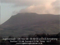
in Web Cameras Ingleborough camera shows the clouds around the summit plateau of Ingleborough hill, near Ingleton in North Yorkshire. Looking North East across the slopes of Ingleborough from the village of Ingleton. Time zone GMT Source refreshes every 5 minutes. posted by: flipflopnick location: Yorkshire, United Kingdom date approved: 11/30/2009 last visited: never |
 view gallery view galleryW1.9 km |  Ingleborough Ingleborough
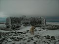
in Mountain Summits Ingleborough is one of the three peaks of Yorkshire,and stands at nearly 2400 feet,it's ascent is a popular walk from the villages of Ingleton and Clapham. posted by:  fellsmanhiker fellsmanhiker location: United Kingdom date approved: 02/09/2009 last visited: 08/02/2015 |
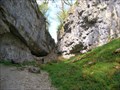 view gallery view gallery S2.4 km S2.4 km
|  Trow Gill, North Yorkshire Trow Gill, North Yorkshire
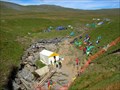
in Places of Geologic Significance Trow Gill is a wooded gorge and an intriguing limestone feature. Is it a receding waterfall or a collapsed chamber? Free access. Pedestrians only. posted by: flipflopnick location: Yorkshire, United Kingdom date approved: 05/29/2008 last visited: 09/03/2014 |
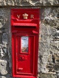 view gallery view gallery NE2.9 km NE2.9 km
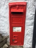
|  Victorian Wall Post Box - Selside, near Settle, Yorkshire, UK Victorian Wall Post Box - Selside, near Settle, Yorkshire, UK
in Victorian Post Boxes Victorian wall post box in Selside in Yorkshire. UK posted by: ntpayne location: Yorkshire, United Kingdom date approved: 08/04/2018 last visited: never |
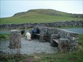
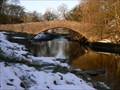
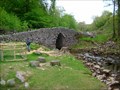 view gallery view galleryS3.1 km |  Clapdale Packhorse bridge, North Yorkshire Clapdale Packhorse bridge, North Yorkshire
in Stone Bridges Clapham Beck runs down Clapdale with this bridge now taking the multitudes across the stream towards Ingleborough fell. It is immediately outside Ingleborough cave entrance. posted by: flipflopnick location: Yorkshire, United Kingdom date approved: 05/27/2008 last visited: 09/03/2014 |
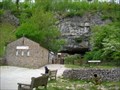 view gallery view galleryS3.1 km | Ingleborough Cave, North Yorkshire in Cave Entrances (Natural) Ingleborough Cave is a popular show cave (entrance fee) about 45 minutes walk from Clapham village (free parking). posted by: flipflopnick location: Yorkshire, United Kingdom date approved: 05/28/2008 last visited: 09/03/2014 |
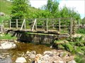 view gallery view galleryS3.4 km |  Clapdale footbridge, North Yorkshire Clapdale footbridge, North Yorkshire
in Hiking Path Footbridges This wooden footbridge spans Clapham Beck. Steep field on one side, unsurfaced track on other side leading to Ingleborough fell. posted by: flipflopnick location: Yorkshire, United Kingdom date approved: 05/27/2008 last visited: 09/03/2014 |
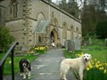 view gallery view galleryS4.8 km |  St.James Parish church-Clapham village,Yorkshire Dales St.James Parish church-Clapham village,Yorkshire Dales
in This Old Church At the head of the famous village of Clapham in the Yorkshire Dales and sited dramatically on the Craven Fault stands the lofty spacious Parish church of St.James the apostle. posted by: fellsmanhiker location: United Kingdom date approved: 04/28/2008 last visited: 12/13/2009 |
 view gallery view gallery E5 km E5 km
|  Pen-y-ghent Cafe - Horton-in-Ribblesdale Pen-y-ghent Cafe - Horton-in-Ribblesdale
in Independent Diners The starting place for a famous walking challenge! posted by: angellica location: Yorkshire, United Kingdom date approved: 07/16/2011 last visited: 07/13/2013 |
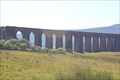 view gallery view gallery N5.8 km N5.8 km
|  Ribblehead Viaduct - Yorkshire, UK Ribblehead Viaduct - Yorkshire, UK
in Railroad Bridges It is the longest and most famous viaduct on the Settle-Carlisle Railway, a railway line passing through some spectacular British scenery. Ribblehead railway station is located less than half a mile to the south of the viaduct posted by: angellica location: Yorkshire, United Kingdom date approved: 07/18/2011 last visited: 09/30/2016 |
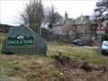 view gallery view galleryW6 km |  Ingleton - Land of Caves and Waterfalls (N. Yorks) Ingleton - Land of Caves and Waterfalls (N. Yorks)
in Welcome Signs Ingleton is on the edge of limestone country, and a popular caving area with some show caves. posted by: flipflopnick location: Yorkshire, United Kingdom date approved: 03/17/2008 last visited: 04/07/2012 |
 view gallery view galleryW6.4 km |  Inglesport, N. Yorks Inglesport, N. Yorks
in Outdoor Recreation Stores Inglesport is THE caving specialist shop in the area. Run by cavers with an excellent cafe upstairs. posted by: flipflopnick location: Yorkshire, United Kingdom date approved: 03/26/2008 last visited: 11/30/2009 |
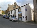
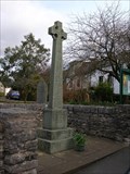 view gallery view galleryW6.6 km |  Great War Memorial, Ingleton, N Yorks Great War Memorial, Ingleton, N Yorks
in World War I Memorials and Monuments This Celtic cross is on the side of Main Street, outside St Mary's parish church. posted by: flipflopnick location: Yorkshire, United Kingdom date approved: 03/16/2008 last visited: 04/07/2012 |
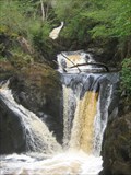 view gallery view galleryW6.6 km |  Pecca Twin Falls Ingleton England Pecca Twin Falls Ingleton England
in Waterfalls The third of the nine falls on the Ingleton Waterfalls Trail posted by: CEO44 location: North West England, United Kingdom date approved: 05/13/2015 last visited: never |
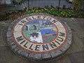 view gallery view galleryW6.6 km |  Ingleton Millennium Garden, N. Yorks Ingleton Millennium Garden, N. Yorks
in Made for the Millennium Ingleton Millennium Garden is one of several projects in the village funded from Yorkshire Dales Millennium Trust. The millennium sign is a mosaic disc. posted by: flipflopnick location: Yorkshire, United Kingdom date approved: 03/17/2008 last visited: 04/09/2011 |
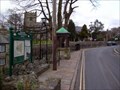 view gallery view galleryW6.6 km |  Ingleton Village Map, N. Yorks Ingleton Village Map, N. Yorks
in 'You Are Here' Maps On the parish council notice board is a village map. posted by: flipflopnick location: Yorkshire, United Kingdom date approved: 03/16/2008 last visited: 04/07/2012 |
 view gallery view galleryW7.1 km | Thornton-in-Lonsdale Millennium viewpoint, Ingleton Yorkshire in Made for the Millennium This fine viewpoint was built to commemorate the millennium at Thornton-in-Lonsdale, near Ingleton. posted by: Tashington location: North West England, United Kingdom date approved: 01/19/2009 last visited: 02/10/2009 |
 view gallery view galleryW7.1 km |  Thornton in Lonsdale Orientation Table viewing station. Thornton in Lonsdale Orientation Table viewing station.
in Orientation Tables The Orientation table at this location identifies the surrounding fells of the Forest of Bowland and the Peaks of The Yorkshire Dales. posted by: fellsmanhiker location: United Kingdom date approved: 05/28/2008 last visited: 09/30/2008 |
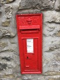
 view gallery view galleryW7.6 km | Victorian Wall Post Box - Thornton in Lonsdale, nr. Ingleton, Yorkshire, UK in Victorian Post Boxes A Victorian wall post box in Thornton in Lonsdale, near Ingleton in Yorkshire posted by: ntpayne location: Yorkshire, United Kingdom date approved: 08/13/2018 last visited: never |
 view gallery view galleryS7.6 km | Victorian Wall Post Box - Lawkland, nr Skipton, Yorkshire, UK in Victorian Post Boxes A Victorian wall post box in Lawkland, near Skipton in Yorkshire posted by: ntpayne location: Yorkshire, United Kingdom date approved: 08/13/2018 last visited: never |
 view gallery view galleryN7.7 km | Whernside in Mountain Summits Whernside (G/NP-004) This is the highest summit in the Yorkshire Dales. posted by: charlieg0pzo location: United Kingdom date approved: 07/28/2007 last visited: 09/30/2016 |
 view gallery view galleryE7.7 km | Pen y Ghent in Mountain Summits Pen y Ghent (G/NP-10) This distinctively-shaped summit is one of the Yorkshire "Three Peaks". The Pennine Way footpath goes over it. posted by: charlieg0pzo location: United Kingdom date approved: 07/28/2007 last visited: 10/01/2016 |
 view gallery view gallery SE8.9 km SE8.9 km
| Stainforth Bridge, Stainforth, Yorkshire, UK in Stone Bridges A delightful pack horse bridge over the River Ribble upstream of Stainforth Foss waterfall posted by: hillhiker1 location: Yorkshire, United Kingdom date approved: 02/02/2010 last visited: 08/29/2014 |
|