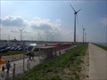
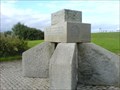
 view gallery view gallery SW9 km SW9 km
|   Eemshaven - The Netherlands Eemshaven - The Netherlands
in Active Rail Locations The train station of Eemshaven is the northernmost station of the Netherlands posted by:  Zugführer Zugführer location: Groningen, Netherlands date approved: 06/04/2018 last visited: 02/18/2023 |
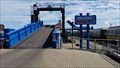 view gallery view gallery W9 km W9 km
|  Borkum Reede, Borkum, Germany Borkum Reede, Borkum, Germany
in Ferries and Ferry Landings Von diesem Terminal fahren die Fähren zum Festland nach Emden *** The ferry's to the mainland start at this terminal posted by: 4spring location: Niedersachsen, Germany date approved: 08/20/2016 last visited: 08/09/2020 |
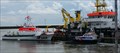 view gallery view galleryW9.5 km |  Alfried Krupp, Borkum, Germany Alfried Krupp, Borkum, Germany
in Lifeboats and Rescue Stations Seit 1988 schützt dieser Seenotrettungskreuzer die westlichste der Ostfriesischen Inseln *** Since 1988 this lifeboat protects the sea around the island Borkum posted by: 4spring location: Niedersachsen, Germany date approved: 08/08/2016 last visited: 08/09/2020 |
 view gallery view galleryW9.5 km |  Königreichssaal Borkum, Germany Königreichssaal Borkum, Germany
in Kingdom Halls of Jehovah's Witnesses Bei Ankunft per Schiff in Borkum sind es nur wenige Meter bis zum Königreichssaal *** When you arrive in Borkum by ship you only have a few meters to the Kingdom Hall posted by: 4spring location: Niedersachsen, Germany date approved: 08/04/2016 last visited: 08/09/2020 |
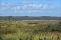 view gallery view galleryW9.5 km |  Waddensea of Lower Saxony - Borkum, Germany Waddensea of Lower Saxony - Borkum, Germany
in UNESCO Geoparks and Biosphere Reserves Das Wattenmeer ist vielfach geschützt. Die Insel Borkum liegt mitten im Wattenmeer *** The Waddensea is multiple protected. The island Borkum is situated in the middel of the Waddensea posted by: 4spring location: Niedersachsen, Germany date approved: 08/28/2016 last visited: 08/09/2020 |
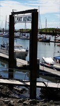 view gallery view galleryW9.7 km |  Port Henry, Borkum, Germany Port Henry, Borkum, Germany
in Sailing and Yacht Clubs Für Segelboote gibt es auf Borkum einen eigenen Hafen: Port Henry *** There is a separate harbour for sailing boats: Port Hentry posted by: 4spring location: Niedersachsen, Germany date approved: 09/04/2016 last visited: 08/09/2020 |
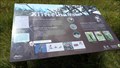
 view gallery view gallery E10.3 km E10.3 km
|  Info Board UNESCO World Heritage Wadden Sea - Leysiel, Germany Info Board UNESCO World Heritage Wadden Sea - Leysiel, Germany
in Flora and Fauna Information Signs Infotafel am äußersten Ende der Leybucht mit Nordseeblick. / Information board at the rear end of Leysiel in the North Sea. posted by: DieCacherGirls location: Niedersachsen, Germany date approved: 04/14/2014 last visited: never |
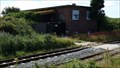
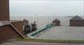 view gallery view galleryE10.3 km |  Leysiel lock - Greetsiel, Germany Leysiel lock - Greetsiel, Germany
in Waterway Locks, Planes and Lifts Leysiel lock connects Greetsiel harbour via an artificial waterway to the North Sea. / Die Leysiel-Schleuse verbindet den Hafen von Greetsiel über einen künstlichen Wasserweg mit der Nordsee. posted by: DieCacherGirls location: Niedersachsen, Germany date approved: 11/24/2012 last visited: never |
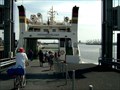 view gallery view gallerySW10.5 km | Grongingerland- Eemshaven in Ferries and Ferry Landings ferryboat from Eemshaven to Borkum (germany) posted by: haxepaxe location: Groningen, Netherlands date approved: 08/29/2007 last visited: 08/06/2016 |
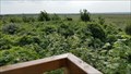 view gallery view gallery NW10.9 km NW10.9 km
|  Steerenkklippdünen, Borkum, Germany Steerenkklippdünen, Borkum, Germany
in Scenic Overlooks Der Standort des Aussichtspunkts wird auch Sternklippdüne genannt. Hier läßt sich die Naturlandschaft, aber auch Seeschwalben (lat. Sterna) beobachten *** This point is also called Sternklippdüne. It is a good place to watch the landscape and scray posted by: 4spring location: Niedersachsen, Germany date approved: 08/18/2016 last visited: 08/12/2020 |
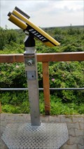 view gallery view galleryNW10.9 km |  BINO - Steerenkklippdünen, Borkum, Germany BINO - Steerenkklippdünen, Borkum, Germany
in Coin-Op Binoculars Auf diesem guten Aussichtspunkt darf ein Fernrohr natürlich nicht fehlen *** As this is a good viewing point you will find a Binocular as well posted by: 4spring location: Niedersachsen, Germany date approved: 08/16/2016 last visited: 08/12/2020 |
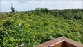 view gallery view galleryNW10.9 km |  Steerenkklippdünen, Borkum, Germany Steerenkklippdünen, Borkum, Germany
in Geographic High Points Der Aussichtspunkts wird auch Sternklippdüne genannt. Hier läßt sich die Naturlandschaft, aber auch Seeschwalben (lat. Sterna) beobachten *** This point is also called Sternklippdüne. Due to its high it is a good place to watch the landscape posted by: 4spring location: Niedersachsen, Germany date approved: 10/21/2016 last visited: 08/12/2020 |
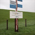
 view gallery view gallery SE11.1 km SE11.1 km
|  Deicharbeiterdenkmal - Dieksiel, Krummhörn Deicharbeiterdenkmal - Dieksiel, Krummhörn
in Maritime Monuments and Memorials Das Denkmal bei Dieksiel erinnert an die Generationen von Deicharbeitern und an die Sturmflut von 1717. / This dyker memorial at North sea is remindful of generations of dykers risking their lifes and also to the flood of 1717. posted by: DieCacherGirls location: Niedersachsen, Germany date approved: 02/28/2014 last visited: never |
 view gallery view gallerySE11.1 km |  Storm flood marker - Dieksiel, Germany Storm flood marker - Dieksiel, Germany
in High Level Marks Marker showing the highest level of storm floods at the North Sea. / Markierungen der höchsten Sturmfluten an der Nordsee. posted by: DieCacherGirls location: Niedersachsen, Germany date approved: 12/12/2012 last visited: never |
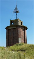
 view gallery view galleryNW11.3 km |  WWII German Radar Borkum, Germany WWII German Radar Borkum, Germany
in World War II Sites Das Haus gehörte zu der X-Sendestation auf Borkum, die hier im September 1939 gebaut wurde *** From September 1939 onwards the German Luftwaffe had a radar station. One house remained. posted by: 4spring location: Niedersachsen, Germany date approved: 08/10/2016 last visited: 08/09/2020 |
 view gallery view galleryNW11.3 km |  WWII German Radar Borkum, Germany WWII German Radar Borkum, Germany
in Luftwaffe Radar Ruins Das Haus gehörte zu der X-Sendestation auf Borkum, die hier im September 1939 gebaut wurde *** From September 1939 onwards the German Luftwaffe had a radar station. One house remained. posted by: 4spring location: Niedersachsen, Germany date approved: 08/10/2016 last visited: 08/06/2021 |
 view gallery view galleryNW11.3 km |  WWII German Radar, Borkum, Germany WWII German Radar, Borkum, Germany
in Military Installations Das Haus gehörte zu der X-Sendestation auf Borkum, die hier im September 1939 gebaut wurde *** From September 1939 onwards the German Luftwaffe had a radar station. One house remained posted by: 4spring location: Niedersachsen, Germany date approved: 02/11/2018 last visited: 08/09/2020 |
 view gallery view galleryNW11.3 km | Sänger auf dem Reededamm, Borkum Germany in Flora and Fauna Information Signs Die Infotafel erläutert auch die Singvogelarten, die hier in den Dünen und Salzwiesen leben *** The information board also explains on the lokal sing birds living in the dunes and the grass up to the sea posted by: 4spring location: Niedersachsen, Germany date approved: 08/12/2016 last visited: 08/09/2020 |
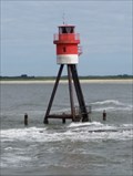 view gallery view galleryW11.3 km |  Fischerbalje, Borkum, Germany Fischerbalje, Borkum, Germany
in Coastal Lighthouses Die Fischerbalje steht am Beginn des Borkumer Leitdamms und leuchtet 3,5 Seemeilen weit *** The "Fischerbalje" is at the beginning of the longitudinal dyke at the harbour of Borkum. The range of the flash light is 3.5 seamile posted by: 4spring location: Niedersachsen, Germany date approved: 11/12/2016 last visited: 08/09/2020 |
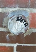 view gallery view galleryNW11.4 km |  Oostbake, Borkum, Germany Oostbake, Borkum, Germany
in German Trigonometric Points Diese Bake im Osten von Borkum ist eine Peileinrichtungen für die Schifffahrt und sie hat einen TP-Bolzen. *** This historical beacon ("Bake") on the island Borkum, was used for guiding ships and it has a TP-stud posted by: 4spring location: Niedersachsen, Germany date approved: 11/15/2016 last visited: 08/03/2016 |
 view gallery view galleryNW11.4 km | Ostbake, Borkum, Germany in Coastal Lighthouses Auf der Insel Borkum stehen vier Baken, als Peileinrichtungen für die Schifffahrt. *** There are four of these historical beacons ("Bake") on the island Borkum, which were used for guiding ships posted by: 4spring location: Niedersachsen, Germany date approved: 11/09/2016 last visited: 04/24/2019 |
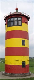
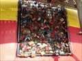 view gallery view galleryE11.4 km |  Padlocks am Leuchtturm - Pilsum, Germany Padlocks am Leuchtturm - Pilsum, Germany
in Love Padlocks Der Otto-Leuchtturm bei Pilsum ist eines der bekanntesten Symbole Ostfrieslands geworden. Nun gibt es hier auch ein Love Padlock. / This lighthouse is one of the best-known symbols of Eastern Frisia. There is a small love padlock. posted by: DieCacherGirls location: Niedersachsen, Germany date approved: 03/24/2014 last visited: 08/28/2019 |
 view gallery view galleryE11.4 km | Pilsumer Leuchtturm in Coastal Lighthouses Der Pilsumer Leuchtturm wurde zusammen mit vier weiteren Leuchttürmen
(alles Leitfeuern): Insel Borkum, Campen, Watum und Delftzyl am 01. Oktober 1891 zeitgleich in Dienst gestellt. posted by: OshnDoc location: Niedersachsen, Germany date approved: 09/22/2011 last visited: 08/28/2019 |
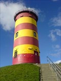 view gallery view galleryE11.4 km |  Otto Leuchtturm - Pilsum, Germany Otto Leuchtturm - Pilsum, Germany
in Official Local Tourism Attractions Der Otto-Leuchtturm bei Pilsum ist eines der bekanntesten Symbole Ostfrieslands geworden. / This lighthouse is one of the best-known symbols of Eastern Frisia. posted by: DieCacherGirls location: Niedersachsen, Germany date approved: 03/12/2014 last visited: 08/28/2019 |
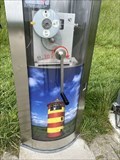 view gallery view galleryE11.4 km |  Pilsumer Leuchtturm - Penny Smasher Pilsumer Leuchtturm - Penny Smasher
in Penny Smashers "Penny Smasher" at the Pilsum Lighthouse. posted by: Tintenklexx location: Niedersachsen, Germany date approved: 06/19/2022 last visited: 10/29/2022 |
|