 view gallery view gallery N2.6 km N2.6 km
|   Spinners Arms, 1 Marsden Street - Hadfield, UK Spinners Arms, 1 Marsden Street - Hadfield, UK
in Pictorial Pub Signs The picture on this pub sign shows a hand spinning machine. posted by:  dtrebilc dtrebilc location: East Midlands, United Kingdom date approved: 06/23/2018 last visited: never |
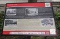 view gallery view galleryN2.7 km |  Sparrow Park - Hadfield Sparrow Park - Hadfield
in UK Historical Markers This sign in a small grassed area known as Sparrow Park is one of 20 similar signs that are located along the route of the Hadfield & Padfield Heritage Trail, the two main villages along the trail. posted by: dtrebilc location: East Midlands, United Kingdom date approved: 06/22/2018 last visited: never |
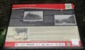 view gallery view galleryN2.7 km | Old Hall And The Square - Hadfield, UK in UK Historical Markers This sign at the village green, is one of 20 similar signs that are located along the route of the Hadfield & Padfield Heritage Trail, the two main villages along the trail. posted by: dtrebilc location: East Midlands, United Kingdom date approved: 06/22/2018 last visited: never |
 view gallery view gallery NW3.1 km NW3.1 km
| The Pear Tree, 431 Hadfield Road - Hadfield, UK in Pictorial Pub Signs As you might expect this pub sign shows a pear tree. posted by: dtrebilc location: East Midlands, United Kingdom date approved: 06/23/2018 last visited: never |
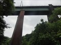
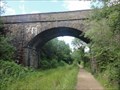
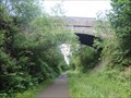 view gallery view galleryN3.1 km |  Arch Road Bridge Over Longdendale Trail - Padfield, UK Arch Road Bridge Over Longdendale Trail - Padfield, UK
in Stone Bridges This single arch bridge carries Padfield MainRoad over the Longdendale Trail, a 'rails to trails' cycle, pedestrian and horse path. posted by: dtrebilc location: East Midlands, United Kingdom date approved: 07/15/2018 last visited: never |
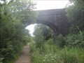
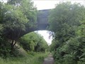 view gallery view galleryN3.1 km |  Road Bridge Over Longdendale Trail - Padfield, UK Road Bridge Over Longdendale Trail - Padfield, UK
in Arch Bridges This single arch bridge carries Padfield Main Road over the Longdendale Trail, a 'rails to trails' cycle, pedestrian and horse path. posted by: dtrebilc location: East Midlands, United Kingdom date approved: 06/21/2018 last visited: never |
 view gallery view gallery W3.2 km W3.2 km
|  Broadbottom Viaduct - Broadbottom, UK Broadbottom Viaduct - Broadbottom, UK
in Railroad Bridges Broadbottom Viaduct (also known as Etherow or Mottram Viaduct) is a railway viaduct that spans the River Etherow between Derbyshire and Greater Manchester in England. posted by: dtrebilc location: North West England, United Kingdom date approved: 07/06/2018 last visited: never |
 view gallery view galleryW3.4 km | Bridge HAJ/50 Over Lower Market Street - Broadbottom, UK in Railroad Bridges This multi-arch railroad bridge carries the Hadfield - Glossop line over Lower Market Street. posted by: dtrebilc location: North West England, United Kingdom date approved: 07/06/2018 last visited: never |
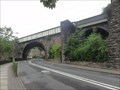 view gallery view galleryW3.4 km | Bridge HAJ/50 Over Lower Market Street - Broadbottom, UK in Stone Bridges This multi-arch railroad bridge carries the Hadfield - Glossop line over Lower Market Street. posted by: dtrebilc location: North West England, United Kingdom date approved: 07/20/2018 last visited: never |
 view gallery view galleryW3.4 km |  Railway Bridge Mural - Broadbottom, UK Railway Bridge Mural - Broadbottom, UK
in Murals This mural of an old style railway train is next to a railway bridge that carries the Hadfield - Glossop line over Lower Market Street. posted by: dtrebilc location: North West England, United Kingdom date approved: 08/25/2018 last visited: never |
 view gallery view galleryW3.4 km | Stone Bridge HAJ/50 Over Lower Market Street - Broadbottom, UK in Arch Bridges This multi-arch railroad bridge carries the Hadfield - Glossop line over Lower Market Street. posted by: dtrebilc location: North West England, United Kingdom date approved: 06/22/2018 last visited: never |
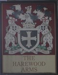 view gallery view galleryW3.5 km | The Harewood Arms in Pictorial Pub Signs This pub sign is the coat of arms of the Earl of Harewood. posted by: dtrebilc location: North West England, United Kingdom date approved: 10/08/2018 last visited: never |
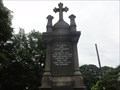 view gallery view galleryW3.9 km |  Longdendale Broadbottom WWI Memorial - Broadbottom, UK Longdendale Broadbottom WWI Memorial - Broadbottom, UK
in World War I Memorials and Monuments This stone monument surmounted by a cross and surrounded by railings was originally erected to commemorate the men of Broadbottom who lost their lives in World War I.
It has subsequently been amended to commemorate the dead from WWII and later wars. posted by: dtrebilc location: United Kingdom date approved: 06/22/2018 last visited: never |
 view gallery view galleryN4 km | Arch Minor Road Bridge Over Longdendale Trail - Padfield, UK in Stone Bridges This single arch bridge carries a minor road over the Longdendale Trail, a 'rails to trails' cycle, pedestrian and horse path. posted by: dtrebilc location: East Midlands, United Kingdom date approved: 07/15/2018 last visited: never |
 view gallery view galleryN4 km | Minor Road Bridge Over Longdendale Trail - Padfield, UK in Arch Bridges This single arch bridge carries a minor road over the Longdendale Trail, a 'rails to trails' cycle, pedestrian and horse path. posted by: dtrebilc location: East Midlands, United Kingdom date approved: 06/21/2018 last visited: never |
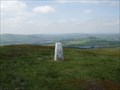 view gallery view gallery NE4.2 km NE4.2 km
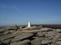
|  Cock Hill Cock Hill
in U.K. and Ireland Trigpoints Cock Hill Trigpoint in the Peak District above Glossop. posted by:  theblack theblack location: United Kingdom date approved: 12/10/2007 last visited: never |
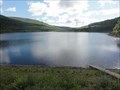 view gallery view galleryN4.8 km |  Rhodeswood Reservoir - Longendale, UK Rhodeswood Reservoir - Longendale, UK
in Water Dams This reservoir was built in 1855 to supply water to the urban area of Manchester. posted by: dtrebilc location: East Midlands, United Kingdom date approved: 08/27/2018 last visited: never |
 view gallery view gallery S5.3 km S5.3 km
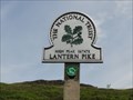
|  Lantern Pike - Hayfield, UK Lantern Pike - Hayfield, UK
in Wikipedia Entries Lantern Pike is a 373 metre high hill in the Peak District National Park. posted by: dtrebilc location: East Midlands, United Kingdom date approved: 09/29/2019 last visited: never |
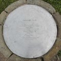 view gallery view galleryS5.3 km |  Edwin Royce Memorial Orientation Table - Hayfield, UK Edwin Royce Memorial Orientation Table - Hayfield, UK
in Citizen Memorials This orientation table marking the highest point on Lantern Pike in the Peak District National Park was erected in commemoration of Edwin Royce who campaigned for public access to the areas of the UK countryside. posted by: dtrebilc location: East Midlands, United Kingdom date approved: 10/01/2019 last visited: never |
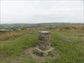
 view gallery view galleryS5.3 km |  Lantern Pike - Hayfield, UK Lantern Pike - Hayfield, UK
in Orientation Tables This orientation table is at the top of a hill called Lantern Pike that is owned by the National Trust and lies within the boundary of the Peak District National Park. posted by: dtrebilc location: East Midlands, United Kingdom date approved: 09/29/2019 last visited: never |
 view gallery view galleryNE5.5 km | Torside Reservoir - Longdendale, UK in Water Dams This reservoir was built in 1864 to supply water to the urban area of Manchester. posted by: dtrebilc location: East Midlands, United Kingdom date approved: 08/25/2018 last visited: 08/15/2022 |
 view gallery view galleryS5.6 km |  Lantern Pike - Hayfield, UK Lantern Pike - Hayfield, UK
in National Trust U.K. Lantern Pike is a 373 metre high hill in the Peak District National Park. posted by: dtrebilc location: East Midlands, United Kingdom date approved: 10/01/2019 last visited: never |
 view gallery view gallery E6 km E6 km
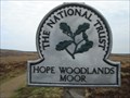
| Hope Woodlands Moor, Derbyshire. in National Trust U.K. Glorious open moorland, high in the Derbyshire Peaks. Access here is from A57 Snake Pass, Glossop to Sheffield. posted by: GeoRams location: United Kingdom date approved: 04/13/2009 last visited: 09/24/2017 |
 view gallery view galleryE6.3 km | Higher Shelfstones in U.K. and Ireland Trigpoints Higher Shelfstones Trigpoint in the Dark Peak above Glossop. posted by: theblack location: United Kingdom date approved: 12/10/2007 last visited: 06/20/2017 |
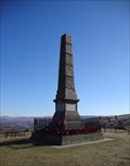 view gallery view galleryW6.3 km | Werneth Low War Memorial Obelisk in World War I Memorials and Monuments An Obelisk on Werneth Low hill, in Memory of those who gave their lives in World War 1 and World War 2. posted by: RedFerret location: North West England, United Kingdom date approved: 03/07/2010 last visited: 09/01/2013 |
|