 view gallery view gallery W0.2 km W0.2 km
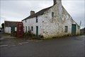
|   Red telephone Box - Llanfihangel, Anglesey, LL71 8BD Red telephone Box - Llanfihangel, Anglesey, LL71 8BD
in Red Telephone Boxes Working red box between two houses on the cross roads posted by:  thek6project thek6project location: North Wales, United Kingdom date approved: 04/03/2020 last visited: 03/19/2020 |
 view gallery view gallery NE1.8 km NE1.8 km
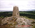
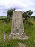
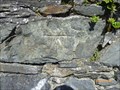
|  Mynydd Bodafon Triangulation Pillar Mynydd Bodafon Triangulation Pillar
in U.K. and Ireland Trigpoints Triangulation Pillar: On the summit of Mynydd Bodafon, near Brynrefail, Ynys Môn. posted by: Meirion location: North Wales, United Kingdom date approved: 09/02/2007 last visited: 06/20/2009 |
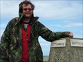 view gallery view galleryNE1.9 km |  Mynydd Bodafon Mynydd Bodafon
in Mountain Summits Mynydd Bodafon (GW/NW-071) This is the second highest summit on the island of Anglesey posted by:  charlieg0pzo charlieg0pzo location: United Kingdom date approved: 08/13/2006 last visited: 03/28/2013 |
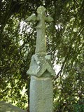 view gallery view galleryNE2.7 km |  Cross - St. Michael's Church, Penrhoslligwy, Ynys Môn, Wales Cross - St. Michael's Church, Penrhoslligwy, Ynys Môn, Wales
in Churchyard Crosses A cross in the churchyard of St. Michael's Church (Eglwys Sant Mihangel), Penrhoslligwy, Ynys Môn, Wales. posted by: Meirion location: North Wales, United Kingdom date approved: 04/21/2011 last visited: never |
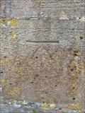
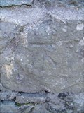
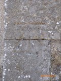
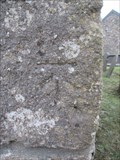
 view gallery view galleryNE2.7 km | Penrhoslligwy, St. Michael's Church in U.K. and Ireland Trigpoints Cut mark: On porch of St. Michael's Church (Eglwys Sant Mihangel), Penrhoslligwy, Ynys Môn. posted by: Meirion location: North Wales, United Kingdom date approved: 04/22/2011 last visited: never |
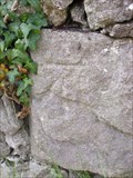
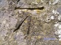
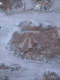
 view gallery view galleryNE2.9 km | Penrhoslligwy, Tyddyn Main in U.K. and Ireland Trigpoints Cut mark: On NW face of house 'Tyddyn main', Penrhoslligwy, Ynys Môn. posted by: Meirion location: North Wales, United Kingdom date approved: 04/22/2011 last visited: never |
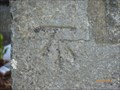
 view gallery view galleryNE3.2 km | Rhôs Lligwy, Wall opposite Bronllwyn in U.K. and Ireland Trigpoints Cut mark: At wall angle on the S side of road opposite 'Bronllwyd', Rhôs Lligwy, Ynys Môn. posted by: Meirion location: North Wales, United Kingdom date approved: 04/24/2011 last visited: never |
 view gallery view gallery SW3.5 km SW3.5 km
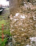
| Coedana, St. Ana's Church in U.K. and Ireland Trigpoints Cut mark: On SW angle of S face of porch at St. Ana's Church, Coedana, Ynys Môn. posted by: Meirion location: North Wales, United Kingdom date approved: 08/31/2010 last visited: never |
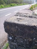 view gallery view galleryNE3.5 km | Rhôs Lligwy, Old milk churn stand in U.K. and Ireland Trigpoints Rivet: On corner of old milk churn stand SW side of the A5025, Rhôs Lligwy, Ynys Môn. posted by: Meirion location: North Wales, United Kingdom date approved: 04/22/2011 last visited: never |
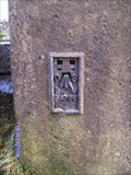
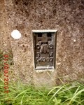 view gallery view galleryNE3.5 km | Brynrefail, Capel Brynrefail in U.K. and Ireland Trigpoints Flush Bracket: On Capel Brynrefail E angle NE face, Brynrefail, Ynys Môn. posted by: Meirion location: North Wales, United Kingdom date approved: 09/01/2007 last visited: 09/01/2007 |
 view gallery view gallery SE3.7 km SE3.7 km
| Brynteg, Capel Soar in U.K. and Ireland Trigpoints Cut mark: On wall at junction of Capel Soar and cemetery NW side road, Brynteg, Ynys Môn. posted by: Meirion location: North Wales, United Kingdom date approved: 07/24/2009 last visited: never |
 view gallery view gallerySE3.9 km | Brynteg, Rhuddlan Fawr Triangulation Pillar in U.K. and Ireland Trigpoints Triangulation Pillar: Rhuddlan Fawr farm, near Brynteg, Ynys Môn. posted by: Meirion location: North Wales, United Kingdom date approved: 07/24/2009 last visited: 03/11/2010 |
 view gallery view galleryW3.9 km | Llannerch-y-medd, Police Station in U.K. and Ireland Trigpoints Cut mark: On E angle of NE face of (old?) Police Station SW side of road, Llannerch-y-medd, Ynys Môn. posted by: Meirion location: North Wales, United Kingdom date approved: 08/30/2010 last visited: never |
 view gallery view gallery N4 km N4 km
| Llaneuddog, Sardis Chapel in U.K. and Ireland Trigpoints Flush Bracket: On Sardis Chapel W angle SW face, Llaneuddog, Ynys Môn. posted by: Meirion location: North Wales, United Kingdom date approved: 01/15/2008 last visited: never |
 view gallery view galleryNE4 km | Rhôs Lligwy, Pont y Felin in U.K. and Ireland Trigpoints Rivet: On the SE parapet of Pont y Felin, Rhôs Lligwy, Ynys Môn. posted by: Meirion location: North Wales, United Kingdom date approved: 04/24/2011 last visited: never |
 view gallery view galleryN4.2 km | Llaneuddog, Pont y Deri in U.K. and Ireland Trigpoints Cut mark: On the SE parapet of Pont y Deri, Llaneuddog, Ynys Môn. posted by: Meirion location: North Wales, United Kingdom date approved: 03/03/2011 last visited: never |
 view gallery view galleryN4.2 km | Llaneuddog, Llan Ddulas Farm in U.K. and Ireland Trigpoints Cut mark: On the NE angle of the N face of a outbuilding at Llan Ddulas farm, Llaneuddog, Ynys Môn. posted by: Meirion location: North Wales, United Kingdom date approved: 03/03/2011 last visited: never |
 view gallery view galleryW4.2 km | Cut Mark- St. Mary's Church Lychgate, Llannerch-y-medd, Ynys Môn, Wales in U.K. and Ireland Trigpoints Cut mark: On the left-hand side of the lychgate at St. Mary's Church, Llannerch-y-medd, Ynys Môn, Wales. posted by: Meirion location: North Wales, United Kingdom date approved: 08/31/2010 last visited: never |
 view gallery view gallery E4.2 km E4.2 km
| Llanallgo, Eglwys Sant Allgo in U.K. and Ireland Trigpoints Cut mark: On St. Allgo's Church NW angle W face, Llanallgo, Ynys Môn. posted by: Meirion location: United Kingdom date approved: 01/23/2008 last visited: never |
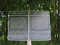
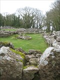 view gallery view galleryNE4.2 km |  Din Lligwy Settlement - Anglesey- North Wales Din Lligwy Settlement - Anglesey- North Wales
in Remains of Settlements An interesting combination of round and rectangular huts, which some historians have suggested is indicative of an Iron Age villa. The houses stone walls and defences comprise limestone slabs, standing up straight on their edges posted by: Norfolk12 location: North Wales, United Kingdom date approved: 04/13/2011 last visited: 06/08/2013 |
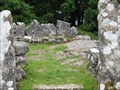 view gallery view galleryNE4.2 km |  Din Lligwy Village - Anglesey, North Wales, UK Din Lligwy Village - Anglesey, North Wales, UK
in Ancient Roman Civilization This ancient monument is hidden away on Anglesey. posted by: Dragontree location: North Wales, United Kingdom date approved: 06/25/2009 last visited: 06/08/2013 |
 view gallery view galleryNE4.2 km |  Din Lligwy Village - Anglesey, North Wales, UK Din Lligwy Village - Anglesey, North Wales, UK
in English Heritage - Cadw - Historic Scotland This ancient monument is hidden away on Anglesey. posted by: Dragontree location: North Wales, United Kingdom date approved: 06/24/2009 last visited: 04/24/2013 |
 view gallery view galleryW4.3 km | Cut Mark - Railway Bridge, Llannerch-y-medd, Ynys Môn, Wales in U.K. and Ireland Trigpoints Cut mark: On parapet of railway bridge on N side of Holyhead Road, Llannerch-y-medd, Ynys Môn, Wales. posted by: Meirion location: North Wales, United Kingdom date approved: 08/31/2010 last visited: never |
 view gallery view gallery S4.3 km S4.3 km
| Cut Mark - St Caian's Church, Tregaian, Ynys Môn, Wales in U.K. and Ireland Trigpoints Cut mark: On the SE angle of St Caian's Church, Tregaian, Ynys Môn, Wales. posted by: Meirion location: North Wales, United Kingdom date approved: 02/27/2018 last visited: never |
 view gallery view galleryNE4.5 km | Lligwy Chapel, Rhôs Lligwy, Ynys Môn, Wales in English Heritage - Cadw - Historic Scotland The remains of a medieval chapel, Rhôs Lligwy, Ynys Môn, Wales. posted by: Meirion location: North Wales, United Kingdom date approved: 04/24/2011 last visited: 04/24/2013 |
|