 view gallery view gallery N1.8 km N1.8 km
|   Windy Knoll, Derbyshire, UK Windy Knoll, Derbyshire, UK
in National Trust U.K. Open moorland in the Derbyshire Peak District posted by:  GeoRams GeoRams location: United Kingdom date approved: 10/21/2007 last visited: 03/20/2010 |
 view gallery view gallery NE1.9 km NE1.9 km
| Winnats Pass, Derbyshire, England in National Trust U.K. Winnats means 'wind gates'. It was a gateway into the fortified village of Castleton in medieval times. The road was surfaced during the Second World War as an alternative to Mam Tor. posted by: GeoRams location: United Kingdom date approved: 10/21/2007 last visited: 07/05/2013 |
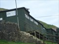
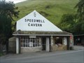 view gallery view galleryNE1.9 km | ") Speedwell Cavern, Derbyshire, England, UK Speedwell Cavern, Derbyshire, England, UK
in Cave Entrances (Artificial) The Speedwell Cavern is one of the four show caves in Castleton, Derbyshire, England. posted by: GeoRams location: United Kingdom date approved: 10/13/2007 last visited: 03/20/2013 |
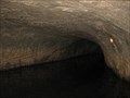 view gallery view galleryNE1.9 km |  Speedwell Cavern - Castleton, Derbyshire, UK Speedwell Cavern - Castleton, Derbyshire, UK
in Mines Speedwell cavern is an old lead mine in the heart of the Peak District. posted by: Dragontree location: East Midlands, United Kingdom date approved: 04/16/2013 last visited: never |
 view gallery view galleryN2.1 km | Blue John Cavern, Derbyshire, England, UK in Cave Entrances (Artificial) The Blue John Cavern is one of the four show caves in Castleton, Derbyshire, England.
posted by: GeoRams location: United Kingdom date approved: 02/07/2012 last visited: 08/12/2009 |
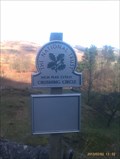
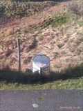
 view gallery view galleryNE2.1 km |  Treak Cliff Bus Stop Treak Cliff Bus Stop
in 'You Are Here' Maps Opposite the Treak Cliff Cavern on the Mam Farm Road posted by: SMacB location: East Midlands, United Kingdom date approved: 02/03/2013 last visited: never |
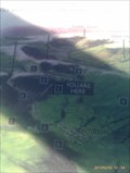
 view gallery view galleryN2.1 km | Treak Cliff Cavern. Derbyshire, England, UK in Cave Entrances (Artificial) Treak Cliff Cavern is a show cave near Castleton in Derbyshire. posted by: GeoRams location: United Kingdom date approved: 10/13/2007 last visited: 10/07/2009 |
 view gallery view galleryN2.1 km | Treak Cliff Cavern - Castleton, Derbyshire, UK in Mines Treak Cliff Cavern is where Blue John stone is mined in the Peak District. posted by: Dragontree location: East Midlands, United Kingdom date approved: 04/16/2013 last visited: 10/07/2009 |
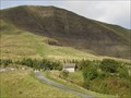
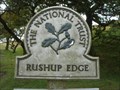 view gallery view galleryN2.3 km | Rushop Edge, Derbyshire, England in National Trust U.K. Open Moorland and spectacular views of Mam Tor. posted by: GeoRams location: United Kingdom date approved: 10/21/2007 last visited: 12/24/2007 |
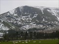
 view gallery view galleryN2.4 km |  Mam Tor - Derbyshire, UK Mam Tor - Derbyshire, UK
in Satellite Imagery Oddities Mam Tor known as the 'shivering mountain' is a hill located near Castleton in the High Peak of Derbyshire. posted by: Poole/Freeman location: East Midlands, United Kingdom date approved: 03/03/2022 last visited: never |
 view gallery view galleryN2.4 km | Crushing Circle, Odin Mine, Castleton in National Trust U.K. On Mam Farm Road, at the entrance to Odin Mine and the Crushing Stone which can be seen from the sign. posted by: SMacB location: East Midlands, United Kingdom date approved: 02/03/2013 last visited: 02/22/2017 |
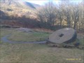 view gallery view galleryN2.4 km |  Crushing Circle, Odin Mine - Castleton, Derbyshire Crushing Circle, Odin Mine - Castleton, Derbyshire
in Millstones Odin Mine is a disused lead mine in the Peak District National Park It lies on a site of 25 hectares near the village of Castleton. It is the oldest documented mine in Derbyshire and is thought to be one of the oldest lead mines in England. posted by: SMacB location: East Midlands, United Kingdom date approved: 04/03/2015 last visited: 02/22/2017 |
 view gallery view galleryNE2.4 km |  Castleton Milestone - Buxton Road, Castleton, Derbyshire, UK Castleton Milestone - Buxton Road, Castleton, Derbyshire, UK
in Milestones This old milestone lies beside the main road into Castleton. posted by: Dragontree location: Eastern England, United Kingdom date approved: 04/15/2013 last visited: never |
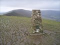 view gallery view galleryN2.4 km |  Mam Tor Mam Tor
in U.K. and Ireland Trigpoints Mam Tor Trigpoint above Edale in the Peak District. posted by:  theblack theblack location: United Kingdom date approved: 12/29/2007 last visited: 04/06/2024 |
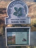
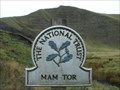 view gallery view galleryN2.4 km | Mam Tor, Derbyshire in National Trust U.K. Mam Tor is a famous viewpoint and landmark, rearing up above the valleys of Hope and Edale. Known as the 'shivering mountain', it is comprised of shale and the East face is a dramatic and loose expanse of crumbling rock. posted by: GeoRams location: United Kingdom date approved: 10/14/2007 last visited: 04/06/2024 |
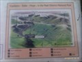 view gallery view galleryNE2.4 km | Peak Cavern, Castleton in 'You Are Here' Maps On the path leading to Peak Cavern in thew Peak District, Castleton, Derbyshire. posted by: SMacB location: East Midlands, United Kingdom date approved: 01/12/2013 last visited: never |
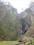 view gallery view galleryNE2.4 km |  The Devil's Arse - (Peak Cavern) - Castleton, Derbyshire, UK The Devil's Arse - (Peak Cavern) - Castleton, Derbyshire, UK
in Geological Devilish Locations The Devil's Arse is a large natural cavern in the Peak District. posted by: Dragontree location: East Midlands, United Kingdom date approved: 04/16/2013 last visited: 12/29/2021 |
 view gallery view galleryNE2.4 km | ") The Devil's Arse - (Peak Cavern) - Castleton, Derbyshire, UK The Devil's Arse - (Peak Cavern) - Castleton, Derbyshire, UK
in Cave Entrances (Natural) The Devil's Arse is a large natural cavern in the Peak District with the largest natural entrance in Britain. posted by: Dragontree location: East Midlands, United Kingdom date approved: 04/15/2013 last visited: 12/29/2021 |
 view gallery view galleryN2.4 km | Mam Tor - Castleton, Derbyshire in National Trust U.K. On the way to Mam Tor, just beyond the turning circle at the end of Mam Farm Road on the now disused road built in 1819 by the Sheffield Turnpike Company using spoil from the nearby Odin mine. posted by: SMacB location: East Midlands, United Kingdom date approved: 07/12/2013 last visited: never |
 view gallery view galleryN2.6 km | Mam Tor, old road in Milestones Metal milestone on the old road to Mam Tor, now disused. posted by: SMacB location: East Midlands, United Kingdom date approved: 02/03/2013 last visited: never |
 view gallery view galleryN2.6 km |  Mam Tor Landslip, Castleton, Derbyshire, UK Mam Tor Landslip, Castleton, Derbyshire, UK
in Places of Geologic Significance A fine example of a rotational landslip on the side of Mam Tor with attendant road destruction posted by: hillhiker1 location: North West England, United Kingdom date approved: 01/20/2010 last visited: 10/07/2009 |
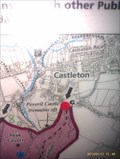
 view gallery view galleryNE2.7 km |  Peveril Castle, Derbyshire, England. Peveril Castle, Derbyshire, England.
in English Heritage - Cadw - Historic Scotland Perched high above the pretty village of Castleton, the castle offers breathtaking views of the Peak District. Founded soon after the Norman Conquest of 1066 by William Peverel, one of King William’s most trusted knights, it played an important role posted by: GeoRams location: United Kingdom date approved: 10/21/2007 last visited: 07/17/2019 |
 view gallery view galleryNE2.7 km | Limestone Way, Castleton, Derbyshire in 'You Are Here' Maps Entrance to the Limestone Way footpath, Castleton, Derbyshire. posted by: SMacB location: East Midlands, United Kingdom date approved: 01/13/2013 last visited: 04/06/2024 |
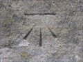 view gallery view galleryNE2.7 km | Cut Mark - Newhall Bridge, Buxton Road, Castleton, Derbyshire in U.K. and Ireland Trigpoints A Cut Mark on a bridge in the village of Castleton. posted by: Dragontree location: East Midlands, United Kingdom date approved: 04/13/2013 last visited: never |
 view gallery view galleryNE2.7 km |  The George, Castle Street - Castleton, UK The George, Castle Street - Castleton, UK
in Pictorial Pub Signs This pub sign of the George shows a picture of King George III. posted by: dtrebilc location: East Midlands, United Kingdom date approved: 09/30/2019 last visited: never |
|