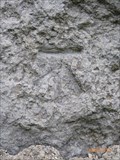
 view gallery view gallery NE0.2 km NE0.2 km
|   Benllech, Tyddyn-Fadog Benllech, Tyddyn-Fadog
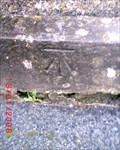
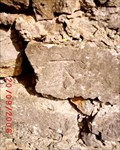
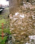
in U.K. and Ireland Trigpoints Cut mark: 2m from NE angle of N face wall of outbuilding at Tyddyn-Fadog on the S side of the road, Benllech, Ynys Môn. posted by:  Meirion Meirion location: North Wales, United Kingdom date approved: 08/06/2010 last visited: never |
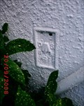
 view gallery view gallery E0.5 km E0.5 km
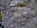
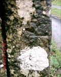
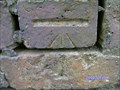
| Benllech, Capel Libanus in U.K. and Ireland Trigpoints Flush Bracket: On Congregational Chapel S side road NE face 8.8m N angle, Benllech, Ynys Môn. posted by: Meirion location: North Wales, United Kingdom date approved: 08/22/2007 last visited: 11/08/2012 |
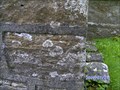
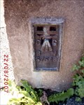
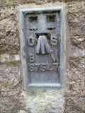 view gallery view galleryE0.5 km |  Flush Bracket - Capel Libanus, Benllech, Ynys Môn, Wales Flush Bracket - Capel Libanus, Benllech, Ynys Môn, Wales
in European Historic Survey Stones, Monuments and Benchmarks An Ordnance Survey benchmark on Capel Libanus, Benllech, Ynys Môn, Wales. posted by: Meirion location: North Wales, United Kingdom date approved: 11/08/2012 last visited: never |
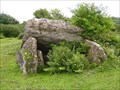 view gallery view gallery SW0.5 km SW0.5 km
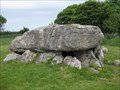
|  Pant-Y-Saer Burial Chamber, Benllech, Ynys Môn, Wales Pant-Y-Saer Burial Chamber, Benllech, Ynys Môn, Wales
in Megalithic Monuments A burial chamber, near Benllech, Ynys Môn, Wales. posted by: Meirion location: North Wales, United Kingdom date approved: 07/24/2009 last visited: never |
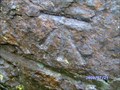 view gallery view gallery W0.5 km W0.5 km
| Benllech, Depot in U.K. and Ireland Trigpoints Cut mark: On depot building SE side road NE face 0.7m N angle, Benllech, Ynys Môn. posted by: Meirion location: North Wales, United Kingdom date approved: 07/23/2009 last visited: never |
 view gallery view galleryNE0.6 km | Benllech, Eglwys Bresbyteraidd Cymru in U.K. and Ireland Trigpoints Cut mark: Welsh Presbyterian Church E face NE angle, Benllech, Ynys Môn. posted by: Meirion location: North Wales, United Kingdom date approved: 02/21/2008 last visited: 12/02/2010 |
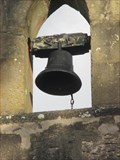 view gallery view galleryW0.6 km |  Bellcote - St Mary's church, Llanfair-Mathafarn-Eithaf, Ynys Môn, Wales Bellcote - St Mary's church, Llanfair-Mathafarn-Eithaf, Ynys Môn, Wales
in Bell Towers A bellcote at St Mary's church, Llanfair-Mathafarn-Eithaf, Ynys Môn, Wales. posted by: Meirion location: North Wales, United Kingdom date approved: 02/18/2018 last visited: never |
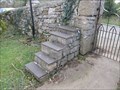 view gallery view galleryW0.6 km |  Mounting Block - St Mary's church, Llanfair-Mathafarn-Eithaf, Ynys Môn, Wales Mounting Block - St Mary's church, Llanfair-Mathafarn-Eithaf, Ynys Môn, Wales
in Historic Upping Stones, Hitching Posts, and Carriage Blocks A mounting block at St Mary's church, Llanfair-Mathafarn-Eithaf, Ynys Môn, Wales. posted by: Meirion location: North Wales, United Kingdom date approved: 02/18/2018 last visited: never |
 view gallery view galleryW0.6 km | Cut Mark - St Mary's Church, Llanfair-Mathafarn-Eithaf, Ynys Môn, Wales in U.K. and Ireland Trigpoints Cut mark: On S angle of St Mary's Church on E side Road, Llanfair-Mathafarn-Eithaf, Ynys Môn, Wales. posted by: Meirion location: North Wales, United Kingdom date approved: 07/23/2009 last visited: never |
 view gallery view galleryE0.6 km | Benllech, Beach Road in U.K. and Ireland Trigpoints Cut mark: On Wall Beach Road, Benllech, Ynys Môn. posted by: Meirion location: North Wales, United Kingdom date approved: 09/20/2008 last visited: never |
 view gallery view gallerySW1 km | Tynygongl, Tabernacle in U.K. and Ireland Trigpoints Cut mark: Tabernacle NE side Road S angle SE face, Tynygongl, Ynys Môn. posted by: Meirion location: United Kingdom date approved: 07/23/2009 last visited: never |
 view gallery view gallery S1.9 km S1.9 km
| Llanbedrgoch, Gatepost at Capel Glasinfryn in U.K. and Ireland Trigpoints Cut mark: On gatepost 2.4m SW of S angle of Capel Glasinfryn, Llanbedrgoch, Ynys Môn. posted by: Meirion location: North Wales, United Kingdom date approved: 04/24/2010 last visited: never |
 view gallery view galleryW2.1 km | Brynteg, Capel Soar in U.K. and Ireland Trigpoints Cut mark: On wall at junction of Capel Soar and cemetery NW side road, Brynteg, Ynys Môn. posted by: Meirion location: North Wales, United Kingdom date approved: 07/24/2009 last visited: never |
 view gallery view galleryS2.4 km | Red Wharf Bay, Springholme in U.K. and Ireland Trigpoints House 'Springholme' W face 1.2m SW angle, Red Wharf Bay, Ynys Môn. posted by: Meirion location: United Kingdom date approved: 09/20/2008 last visited: never |
 view gallery view gallery NW2.6 km NW2.6 km
| Llanallgo, Eglwys Sant Allgo in U.K. and Ireland Trigpoints Cut mark: On St. Allgo's Church NW angle W face, Llanallgo, Ynys Môn. posted by: Meirion location: United Kingdom date approved: 01/23/2008 last visited: never |
 view gallery view gallery N2.6 km N2.6 km
| Llanallgo, Old School in U.K. and Ireland Trigpoints Flush Bracket: On the E angle of NE face of former Llanallgo school, Llanallgo, Ynys Môn. posted by: Meirion location: North Wales, United Kingdom date approved: 08/22/2007 last visited: 08/22/2007 |
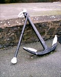
 view gallery view galleryN2.7 km |  Anchor - Llanallgo, Anglesey, North Wales, UK Anchor - Llanallgo, Anglesey, North Wales, UK
in Anchors A large anchor in the middle of the roundabout at Llanallgo. posted by: Dragontree location: North Wales, United Kingdom date approved: 06/24/2009 last visited: never |
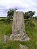 view gallery view gallerySW3.1 km | Brynteg, Rhuddlan Fawr Triangulation Pillar in U.K. and Ireland Trigpoints Triangulation Pillar: Rhuddlan Fawr farm, near Brynteg, Ynys Môn. posted by: Meirion location: North Wales, United Kingdom date approved: 07/24/2009 last visited: 03/11/2010 |
 view gallery view galleryN3.1 km | Cut Mark - Tyddyn-Y-Ffrwd gatepost, Moelfre, Ynys Môn, Wales in U.K. and Ireland Trigpoints Cut mark: Gatepost (Tyddyn-Y-Ffrwd) SE side Road junction fence, Moelfre, Ynys Môn, Wales. posted by: Meirion location: North Wales, United Kingdom date approved: 02/21/2008 last visited: never |
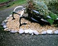 view gallery view galleryN3.2 km | Moelfre, Rowen Cottage Anchors in Anchors A pair of smallish anchors, Molefre, Ynys Môn, Wales. posted by: Meirion location: North Wales, United Kingdom date approved: 01/18/2008 last visited: never |
 view gallery view galleryN3.4 km | (LEGACY) Moelfre, The Wheel & Anchor Fish & Chip Shop in Anchors ** LEGACY LOCATION ** A large anchor on display in car park, Moelfre, Ynys Môn, Wales posted by: Meirion location: North Wales, United Kingdom date approved: 01/18/2008 last visited: never |
 view gallery view galleryN3.5 km | Din Lligwy Burial Chamber - Anglesey, North Wales, UK in Megalithic Monuments This small Neolithic burial chamber is hidden away on Anglesey. posted by: Dragontree location: North Wales, United Kingdom date approved: 06/24/2009 last visited: 06/08/2013 |
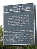 view gallery view galleryN3.5 km |  Din Lligwy Burial Chamber - Anglesey, North Wales, UK Din Lligwy Burial Chamber - Anglesey, North Wales, UK
in English Heritage - Cadw - Historic Scotland This small Neolithic burial chamber is hidden away on Anglesey. posted by: Dragontree location: North Wales, United Kingdom date approved: 06/24/2009 last visited: 06/08/2013 |
 view gallery view galleryS3.5 km | Pentraeth, Old Railway Bridge in U.K. and Ireland Trigpoints Cut mark: On wall (old) railway bridge NE side road at angle of wall, Pentraeth, Ynys Môn. posted by: Meirion location: North Wales, United Kingdom date approved: 07/09/2009 last visited: never |
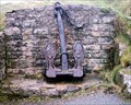 view gallery view galleryN3.5 km | Moelfre, 'Hindlea' Shipwreck Anchor in Anchors An anchor from a shipwreck, Moelfre, Ynys Môn, Wales. posted by: Meirion location: North Wales, United Kingdom date approved: 01/18/2008 last visited: never |
|