 view gallery view gallery E28.2 km E28.2 km
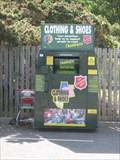
|   Salvation Army Drop Off, Car Park, Tywyn, Gwynedd, Wales, UK Salvation Army Drop Off, Car Park, Tywyn, Gwynedd, Wales, UK
in Permanent Charity Donation Locations A salvation army drop off box at the end of a car park in Tywyn, just off stations road. posted by:  Ddraig Ddu Ddraig Ddu location: North Wales, United Kingdom date approved: 07/04/2011 last visited: never |
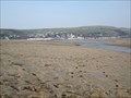
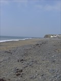 view gallery view galleryE29.6 km |  Clarach Bay Beach, Clarach, Aberystwyth, Ceredigion, Wales, UK Clarach Bay Beach, Clarach, Aberystwyth, Ceredigion, Wales, UK
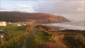
in Beaches Clarach Bay Beach is a stunning bay like beach near a number of caravan parks and attractions. The coordinates:- 52.436300, -4.08080 are for the main entrance to the beach and ramp down. posted by: Ddraig Ddu location: South Wales, United Kingdom date approved: 03/27/2011 last visited: 01/10/2007 |
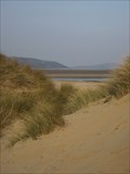 view gallery view galleryE29.6 km |  Ynylsas National Park of Wales, Ceredigion, Wales, UK Ynylsas National Park of Wales, Ceredigion, Wales, UK
in Official Local Tourism Attractions Ynyslas is a National Park of Wales and is built up of a sand beach with a large area of sand dunes at its centre, it forms a small peninsular at the north-west point of the county of Ceredigion. It is a wildlife reserve for endangered bird species. posted by: Ddraig Ddu location: South Wales, United Kingdom date approved: 04/11/2012 last visited: never |
 view gallery view galleryE29.8 km |  Afon Clarach, Clarach Bay, Ceredigion, Wales, UK Afon Clarach, Clarach Bay, Ceredigion, Wales, UK
in Wikipedia Entries The Afon Clarach (English: River Clarach) is a small river discharging into Cardigan Bay north of Aberystwyth. It flows through a largely agricultural and forested landscape except in its lowest reaches where its banks are crowded with holiday homes. posted by: Ddraig Ddu location: South Wales, United Kingdom date approved: 12/31/2011 last visited: never |
 view gallery view galleryE29.8 km |  DESTINATION, Afon Clarach, Clarach Bay, Ceredigion, Wales, UK DESTINATION, Afon Clarach, Clarach Bay, Ceredigion, Wales, UK
in River Origins, Destinations and Confluences The Afon Clarach (English: River Clarach) is a small river discharging into Cardigan Bay north of Aberystwyth. It flows through a largely agricultural and forested landscape except in its lowest reaches where its banks are crowded with holiday homes. posted by: Ddraig Ddu location: South Wales, United Kingdom date approved: 01/04/2012 last visited: never |
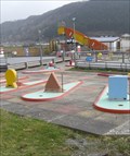 view gallery view galleryE29.8 km |  Miniature Golf, Clarach Bay, Ceredigion, Wales, UK Miniature Golf, Clarach Bay, Ceredigion, Wales, UK
in Miniature Golf A nine hole miniature golf course at the attractions in Clarach Bay park. posted by: Ddraig Ddu location: South Wales, United Kingdom date approved: 03/29/2011 last visited: 01/10/2007 |
 view gallery view galleryE29.8 km | Ynyslas Beach, Ceredigion, Wales, UK in Beaches Ynyslas is a sand beach with a large area of sand dunes at its centre, it forms a small peninsular at the north-west point of the county of Ceredigion. posted by: Ddraig Ddu location: South Wales, United Kingdom date approved: 04/04/2012 last visited: never |
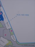
 view gallery view galleryE29.8 km |  Sign, Clarach Bay Restaurant, Aberystwyth, Ceredigion, Wales Sign, Clarach Bay Restaurant, Aberystwyth, Ceredigion, Wales
in 'You Are Here' Maps A sign near the restaurant in Clarach bay, with the words in rather large lettering! And thankfully also on the map. posted by: Ddraig Ddu location: South Wales, United Kingdom date approved: 03/27/2011 last visited: never |
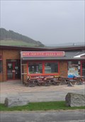
 view gallery view galleryE29.8 km |  Hot Donuts, Clarach Holiday Village, Clarach, Aberystwyth, Ceredigion, Wales, UK Hot Donuts, Clarach Holiday Village, Clarach, Aberystwyth, Ceredigion, Wales, UK
in Independent Doughnut Shops A donut store as part of a restaurant complex in the Clarach holiday Village 3 miles north of Aberystwyth in Ceredigion. posted by: Ddraig Ddu location: South Wales, United Kingdom date approved: 07/06/2011 last visited: never |
 view gallery view galleryE29.8 km |  Rare Whale Washed Up - Clarach, Aberystwyth, Ceredigion, Wales, UK Rare Whale Washed Up - Clarach, Aberystwyth, Ceredigion, Wales, UK
in News Article Locations A 15ft (4.5m) long dead whale has been found washed up on a beach near Aberystwyth. The male animal, believed to be a rare Sowerby's beaked whale, was discovered in Clarach Bay. posted by: Ddraig Ddu location: South Wales, United Kingdom date approved: 03/28/2016 last visited: never |
 view gallery view galleryE29.8 km |  Pizza Bar - Clarach Bay, Aberystwyth, Ceredigion, Wales, UK Pizza Bar - Clarach Bay, Aberystwyth, Ceredigion, Wales, UK
in Independent Pizza Restaurants A pizza restaurant that is part of a restaurant complex in Clarach Holiday Village. posted by: Ddraig Ddu location: South Wales, United Kingdom date approved: 07/06/2011 last visited: never |
 view gallery view galleryE29.8 km |  Ynylsas National Park of Wales, Ceredigion, Wales, UK Ynylsas National Park of Wales, Ceredigion, Wales, UK
in National Parks of the World Ynyslas is a National Park of Wales and is built up of a sand beach with a large area of sand dunes at its centre, it forms a small peninsular at the north-west point of the county of Ceredigion. It is a wildlife reserve for endangered bird species. posted by: Ddraig Ddu location: South Wales, United Kingdom date approved: 04/16/2012 last visited: never |
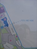
 view gallery view galleryE29.8 km | Sign, Clarach Bay Car Park, Aberystwyth, Ceredigion, Wales in 'You Are Here' Maps A sign on the Clarach bay car park showing the words you are here for all to see. posted by: Ddraig Ddu location: South Wales, United Kingdom date approved: 03/28/2011 last visited: never |
 view gallery view galleryE29.8 km | ") Fault Propagation Cave, Constitution Hill, Aberystwyth, Ceredigion, Wales, UK Fault Propagation Cave, Constitution Hill, Aberystwyth, Ceredigion, Wales, UK
in Cave Entrances (Natural) A fault propagation cave that has cut a cave through the cliff face forming a tunnel that you can climb through. posted by: Ddraig Ddu location: South Wales, United Kingdom date approved: 06/25/2011 last visited: never |
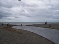
 view gallery view gallery SE29.8 km SE29.8 km
|  Pivot, Large look out, New Promenade, Aberystwyth, Ceredigion, Wales, UK Pivot, Large look out, New Promenade, Aberystwyth, Ceredigion, Wales, UK
in European Historic Survey Stones, Monuments and Benchmarks A pivot on the large v shaped look out on the far west of the New promenade. posted by: Ddraig Ddu location: South Wales, United Kingdom date approved: 11/18/2011 last visited: never |
 view gallery view gallerySE29.8 km |  Pivot, Large look out, New Promenade, Aberystwyth, Ceredigion, Wales, UK Pivot, Large look out, New Promenade, Aberystwyth, Ceredigion, Wales, UK
in U.K. and Ireland Trigpoints A pivot on the large v shaped look out on the far west of the New promenade. posted by: Ddraig Ddu location: South Wales, United Kingdom date approved: 10/24/2011 last visited: never |
 view gallery view galleryE29.8 km | Ynyslas, Ceredigion, Wales, UK in Wikipedia Entries Ynyslas is a sand beach with a large area of sand dunes at its centre, it forms a small peninsular at the north-west point of the county of Ceredigion. posted by: Ddraig Ddu location: South Wales, United Kingdom date approved: 04/04/2012 last visited: never |
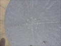 view gallery view gallerySE29.9 km |  Compass Rose, New Prominade, Aberystwyth, Ceredigion, Wales, UK Compass Rose, New Prominade, Aberystwyth, Ceredigion, Wales, UK
in Compass Roses A compass rose at the centre of a directional marker of distances to not so local places from this point. posted by: Ddraig Ddu location: South Wales, United Kingdom date approved: 05/30/2013 last visited: never |
 view gallery view gallerySE29.9 km |  Aberystwyth GC Tourguide, Wales, UK Aberystwyth GC Tourguide, Wales, UK
in Geocaching Tour Guides Ever in the Aberystwyth area or in any of Ceredigion, Then I'll lend a hand either remotely or in person if you'd like! posted by: Ddraig Ddu location: South Wales, United Kingdom date approved: 02/01/2011 last visited: 12/19/2010 |
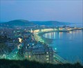
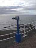 view gallery view gallerySE29.9 km |  Bino view of Cardigan Bay 2, Aberystwyth Castle, Ceredigion, Wales Bino view of Cardigan Bay 2, Aberystwyth Castle, Ceredigion, Wales
in Coin-Op Binoculars A bino on the most westerly point on the corner of the Aberystwyth New Promenade. From here there are clear view north to the arm of Wales. posted by: Ddraig Ddu location: South Wales, United Kingdom date approved: 01/27/2011 last visited: never |
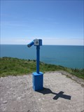 view gallery view galleryE29.9 km | Bino, War Memorial Mound, Borth, Ceredigion, Wales, UK in Coin-Op Binoculars A BINO at the top of the war memorial mound on the south end of Borth along the coastal walk between Aberystwyth and Ynyslas. posted by: Ddraig Ddu location: North Wales, United Kingdom date approved: 09/06/2013 last visited: never |
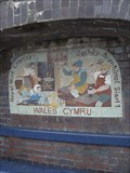 view gallery view gallerySE29.9 km |  Royal Mint 1637, New Promenade, Aberystwyth, Ceredigion, Wales Royal Mint 1637, New Promenade, Aberystwyth, Ceredigion, Wales
in Mosaics A mosaic at the foot of Aberystwyth castle, this depicts the minting that occurred near the castle under the reign of Charles I posted by: Ddraig Ddu location: South Wales, United Kingdom date approved: 01/26/2011 last visited: 08/04/2012 |
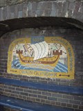 view gallery view gallerySE29.9 km | Treaty with France, New Promenade, Aberystwyth, Ceredigion, Wales in Mosaics A mosaic at the foot of Aberystwyth castle, this depicts the Treaty Owain Glyndwr made with France to strengthen his power in Wales as the last true Prince of Wales posted by: Ddraig Ddu location: South Wales, United Kingdom date approved: 01/26/2011 last visited: 08/04/2012 |
 view gallery view gallerySE29.9 km |  Aberystwyth Castle - Satellite Oddity - Ceredigion, Wales. Aberystwyth Castle - Satellite Oddity - Ceredigion, Wales.
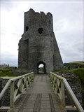
in Satellite Imagery Oddities A ancient series of Castle ruins, featured on Virtual Globetrotting. The Castle stands over looking Cardigan bay, & dates back to 1277 built by English King, Edward 1st on his campaign to take power in Wales. posted by: veritas vita location: South Wales, United Kingdom date approved: 12/29/2015 last visited: 03/24/2016 |
 view gallery view gallerySE29.9 km |  Humanity - War Memorial - Aberystwyth, Wales. Humanity - War Memorial - Aberystwyth, Wales.
in Figurative Public Sculpture The Aberystwyth town war memorial is considered by many to be one of the finest in Britain. The figure at the base represents Humanity emerging from the effects of war. The sculpture is one of only three in Britain designed by Italian Mario Rutelli posted by: veritas vita location: South Wales, United Kingdom date approved: 09/04/2012 last visited: 10/27/2012 |
|