 view gallery view gallery W3.4 km W3.4 km
|   Layby, A44, Eisteddfa Gurig, Ceredigion, Wales, UK Layby, A44, Eisteddfa Gurig, Ceredigion, Wales, UK
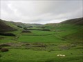
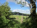
in Scenic Roadside Look-Outs A layby on the east side of a large flat valley near Eisteddfa Gurig. posted by:  Ddraig Ddu Ddraig Ddu location: South Wales, United Kingdom date approved: 11/14/2011 last visited: never |
 view gallery view gallery SW5.5 km SW5.5 km
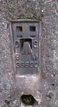
|  Trigometric Pillar, Bryn Garw, Pen y Garn, Cwm Ystwyth, Ceredigion, Wales, UK Trigometric Pillar, Bryn Garw, Pen y Garn, Cwm Ystwyth, Ceredigion, Wales, UK
in European Historic Survey Stones, Monuments and Benchmarks A trig Pillar on the top of Banc Garw on Pen y Garn. posted by: Ddraig Ddu location: North Wales, United Kingdom date approved: 03/29/2016 last visited: never |
 view gallery view gallery NW6.1 km NW6.1 km
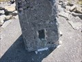
|  Triangulation Pillar - Plynmon Fawr, Ceredigion, Wales, UK Triangulation Pillar - Plynmon Fawr, Ceredigion, Wales, UK
in U.K. and Ireland Trigpoints A flush bracket on a trig point pillar on the summit of Plymonfawr in Ceredigion. posted by: Ddraig Ddu location: South Wales, United Kingdom date approved: 07/26/2014 last visited: never |
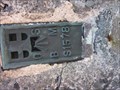 view gallery view galleryNW6.1 km | Flush Bracket, Plynmon Fawr, Ceredigion, Wales, UK in European Historic Survey Stones, Monuments and Benchmarks A flush bracket on a trig point pillar on the summit of Plymonfawr in Ceredigion. posted by: Ddraig Ddu location: South Wales, United Kingdom date approved: 07/27/2014 last visited: never |
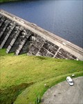
 view gallery view galleryNW8 km |  Nant Y Moch Dam, Ponterwyd, Ceredigion, Wales Nant Y Moch Dam, Ponterwyd, Ceredigion, Wales
in Water Dams Nant-y-moch Dam and Reservoir was created in 1964. The construction of the dam flooded the valley south of it, which included the hamlet of Nant-y-moch. posted by: Ddraig Ddu location: South Wales, United Kingdom date approved: 12/26/2010 last visited: never |
 view gallery view galleryNW8.2 km |  Windfarm Fast Tracked - Nant-y-Moch, Ceredigion, Wales, UK Windfarm Fast Tracked - Nant-y-Moch, Ceredigion, Wales, UK
in News Article Locations Furious protestors have been left devastated as controversial plans to build the biggest windfarm in Wales near Aberystwyth could now be pushed through by a new Bristol-based commission designed to fast-track major planning applications. posted by: Ddraig Ddu location: South Wales, United Kingdom date approved: 12/10/2011 last visited: never |
 view gallery view gallery E8.5 km E8.5 km
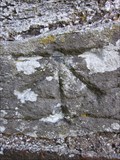
| Cut Mark, Medieval Church, Llangurig, Powys, Wales, UK in European Historic Survey Stones, Monuments and Benchmarks A cut mark on the south west face of the medieval church in Llangurig. posted by: Ddraig Ddu location: South Wales, United Kingdom date approved: 11/22/2011 last visited: never |
 view gallery view galleryE8.5 km | Cut Mark, Medieval Church, Llangurig, Powys, Wales, UK in U.K. and Ireland Trigpoints A cut mark on the south west face of the medieval church in Llangurig. posted by: Ddraig Ddu location: South Wales, United Kingdom date approved: 06/29/2011 last visited: never |
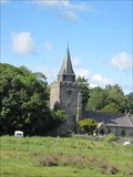 view gallery view galleryE8.5 km |  Llangurig Church, Llangurig, Powys, Wales, UK Llangurig Church, Llangurig, Powys, Wales, UK
in Medieval Churches The church was founded around 550AD by the local monastery in Strata Florida (now a ruin) posted by: Ddraig Ddu location: South Wales, United Kingdom date approved: 07/01/2011 last visited: never |
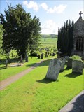 view gallery view galleryE8.5 km |  Churchyard, Llangurig, Powys, Wales, UK Churchyard, Llangurig, Powys, Wales, UK
in Churchyard Cemeteries A churchyard most of it in good condition, but part of it to the north west is overgrown. posted by: Ddraig Ddu location: South Wales, United Kingdom date approved: 07/01/2011 last visited: never |
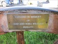 view gallery view galleryE8.5 km |  Williams - Church Yard, Llangurig, Powys, Wales, UK Williams - Church Yard, Llangurig, Powys, Wales, UK
in Dedicated Benches A fantastic looking chair in the Church yard made from a old wagon wheel. posted by: Ddraig Ddu location: South Wales, United Kingdom date approved: 06/30/2011 last visited: never |
 view gallery view galleryE8.5 km |  Wheel Chair, Church Yard, Llangurig, Powys, Wales, UK Wheel Chair, Church Yard, Llangurig, Powys, Wales, UK
in Artistic Seating A fantastic looking chair in the Church yard made from a old wagon wheel. posted by: Ddraig Ddu location: South Wales, United Kingdom date approved: 06/30/2011 last visited: never |
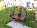 view gallery view galleryE8.5 km |  Wagon Chair, Church Yard, Llangurig, Powys, Wales, UK Wagon Chair, Church Yard, Llangurig, Powys, Wales, UK
in Wagon Wheels A fantastic looking chair in the Church yard made from a old wagon wheel as the main section to lean on. posted by: Ddraig Ddu location: South Wales, United Kingdom date approved: 07/01/2011 last visited: never |
 view gallery view galleryE8.5 km |  HIGHEST- Village in Wales - Llangurig, Wales HIGHEST- Village in Wales - Llangurig, Wales
in Superlatives Llangurig is highest village in Wales at an altitude of 1000 feet posted by: Ddraig Ddu location: South Wales, United Kingdom date approved: 07/01/2011 last visited: never |
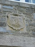
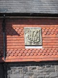
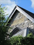 view gallery view galleryE8.5 km |  1895 - Church House, Llangurig, Powys, Wales, UK 1895 - Church House, Llangurig, Powys, Wales, UK
in Dated Buildings and Cornerstones A date stone on the side of a church house on the north side of the A44 in Llangurig. posted by: Ddraig Ddu location: South Wales, United Kingdom date approved: 06/30/2011 last visited: never |
 view gallery view galleryE8.5 km |  Psalm 104:10 - Lloyd Verney Fountain - Llangurig, Powys, Wales, UK Psalm 104:10 - Lloyd Verney Fountain - Llangurig, Powys, Wales, UK
in Etched in Stone A Psalm written in a fountains back as a fitting religious quote for the water that has been re-directed for this fountain. posted by: Ddraig Ddu location: South Wales, United Kingdom date approved: 07/01/2011 last visited: never |
 view gallery view galleryE8.5 km |  Post Office, A44, Llangurig, Powys, Wales, UK Post Office, A44, Llangurig, Powys, Wales, UK
in UK Post Offices A post office in the highest village in Wales of Llangurig. posted by: Ddraig Ddu location: South Wales, United Kingdom date approved: 06/30/2011 last visited: never |
 view gallery view galleryE8.5 km | 1891 - The Post Office, A44, Llangurig, Powys, Wales, UK in Dated Buildings and Cornerstones A post office that according to the owner has always been on and built for that use. The date stone is right up the top. posted by: Ddraig Ddu location: South Wales, United Kingdom date approved: 06/30/2011 last visited: never |
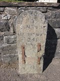 view gallery view galleryE8.5 km |  Milestone, A44, Llangurig, Powys, Wales, UK Milestone, A44, Llangurig, Powys, Wales, UK
in Milestones A mile stone on the north side of the road in Llangurig. posted by: Ddraig Ddu location: South Wales, United Kingdom date approved: 07/01/2011 last visited: never |
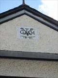
 view gallery view galleryE8.7 km | 1907 - Private House, Wye Road, Llangurig, Powys, Wales, UK in Dated Buildings and Cornerstones A dated carved stone on the top floor on a private house in Llangurig. posted by: Ddraig Ddu location: South Wales, United Kingdom date approved: 06/30/2011 last visited: never |
 view gallery view galleryE8.7 km | 1888 - The Red Lion, A44, Llangurig, Powys, Wales, UK in Dated Buildings and Cornerstones A date stone on the side of the Red Lion pub on the north side of Llangurig. posted by: Ddraig Ddu location: South Wales, United Kingdom date approved: 06/30/2011 last visited: never |
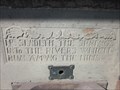
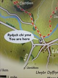 view gallery view galleryE8.7 km |  Sign, Wye Cark Park, Llangurig, Powys, Wales, UK Sign, Wye Cark Park, Llangurig, Powys, Wales, UK
in 'You Are Here' Maps A sign with the current location with reference to a river walk in Llangurig. posted by: Ddraig Ddu location: South Wales, United Kingdom date approved: 06/30/2011 last visited: never |
 view gallery view galleryW9.2 km |  Silver Lead Mine, Llywernog, Ponterwyd, Aberystwyth, Ceredigion Silver Lead Mine, Llywernog, Ponterwyd, Aberystwyth, Ceredigion
in Official Local Tourism Attractions Llywernog Silver-Lead Mine is an award winning all weather tourist attraction in Mid Wales, close to Aberystwyth. It has guided tours, gold panning, tea rooms and gift shop all under the authority of the National Trust. posted by: Ddraig Ddu location: South Wales, United Kingdom date approved: 07/17/2011 last visited: never |
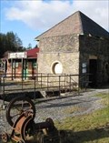 view gallery view galleryW9.2 km |  Silver Lead Mine, Llywernog, Ponterwyd, Aberystwyth, Ceredigion Silver Lead Mine, Llywernog, Ponterwyd, Aberystwyth, Ceredigion
in Mines Llywernog Silver-Lead Mine is an award winning all weather tourist attraction in Mid Wales, close to Aberystwyth. It has guided tours, gold panning, tea rooms and gift shop all under the authority of the National Trust. posted by: Ddraig Ddu location: South Wales, United Kingdom date approved: 01/23/2011 last visited: never |
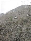 view gallery view gallerySW9.3 km |  Hut, Devils Bridge, Ceredigion, Wales, UK Hut, Devils Bridge, Ceredigion, Wales, UK
in Remote Backcountry Shelters A useful hut for if you are caught out in the dark around the devils bridge walk. Vital as the area is exposed and prone to flooding, this spot provides a vital spot to call for help. posted by: Ddraig Ddu location: South Wales, United Kingdom date approved: 06/24/2012 last visited: 08/19/2017 |
|