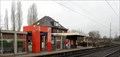
 view gallery view gallery SW3.4 km SW3.4 km
|   Wessel - Germany Wessel - Germany
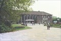
in Train Stations/Depots Wesel is a railway station in Wesel, North Rhine-Westphalia, Germany. posted by:  superstein superstein location: Nordrhein-Westfalen, Germany date approved: 12/22/2017 last visited: never |
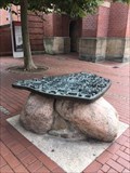 view gallery view gallerySW3.5 km |  Stadtplan Wesel, Germany Stadtplan Wesel, Germany
in 3D Map Models of Our World and Beyond Auf dieser 3D-Karte ist die Stadt Wesel zu sehen.
Das Modell befindet sich auf dem Berliner Tor Platz.
The city of Wesel can be seen on this 3D map.
The model is located on Berliner Tor Platz. posted by: K*gari location: Nordrhein-Westfalen, Germany date approved: 08/31/2020 last visited: 10/23/2020 |
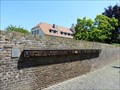
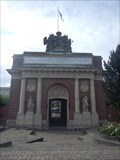 view gallery view gallerySW3.5 km |  Berlin Gate, Wesel, Deutschland Berlin Gate, Wesel, Deutschland
in Freestanding Arches Former city gate of Wesel which is now a momument which houses an Italian restaurant posted by: Becktracker location: Nordrhein-Westfalen, Germany date approved: 02/23/2020 last visited: 10/23/2020 |
 view gallery view gallery W4.2 km W4.2 km
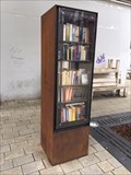
|  Book Exchange- Wesel, Germany Book Exchange- Wesel, Germany
in Free Community Book Exchanges An diesem öffentlichen Bücherschrank am Leyens-Platz können Bücher kostenlos getauscht oder ausgeliehen werden.
Jeder kann seine gebrauchten Bücher hier zu Verfügung stellen, damit andere Interessierte diese nutzen können.
Books can be exchanged or borrowed free of charge at this public bookcase on Leyens-Platz.
Everyone can make their used books available here so that other interested parties can use them.
The bookcase is open and accessible at all times. posted by: K*gari location: Nordrhein-Westfalen, Germany date approved: 09/02/2020 last visited: 10/23/2020 |
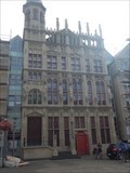 view gallery view galleryW4.3 km |  Historic Rathaus of Wesel, Wesel, Deutschland Historic Rathaus of Wesel, Wesel, Deutschland
in Gothic Architecture Medieval city hall of Wesel, largely destroyed during the second world war and rebuilt in thesame gothic style afterwards posted by: Becktracker location: Nordrhein-Westfalen, Germany date approved: 02/23/2020 last visited: 08/30/2020 |
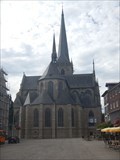 view gallery view galleryW4.3 km |  Willibrordi-Dom, Wesel, Deutschland Willibrordi-Dom, Wesel, Deutschland
in This Old Church Great Gothic-style church in the centre of Wesel, Germany posted by: Becktracker location: Nordrhein-Westfalen, Germany date approved: 02/23/2020 last visited: 09/02/2016 |
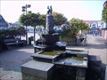
 view gallery view gallery E6.4 km E6.4 km
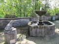
|  Frosch Brunnen Krudenburg Frosch Brunnen Krudenburg
in Fountains Brunnen befindet sich auf einem kleine Platz oberhalb der Lippe posted by:  diddler diddler location: Nordrhein-Westfalen, Germany date approved: 08/24/2010 last visited: 09/11/2011 |
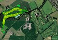
 view gallery view gallery NE6.6 km NE6.6 km
|  Golfclub Weselerwald Golfclub Weselerwald
in Public and Private Golf Courses 18 Hole Course, 6.047 m, PAR 72
(4x PAR 5, 10x PAR 4, 4x PAR 3)
9 Hole Public Course, 1.135 m, PAR 28(56)
(1x PAR 4) posted by: diddler location: Nordrhein-Westfalen, Germany date approved: 09/16/2006 last visited: never |
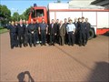 view gallery view gallery SE6.8 km SE6.8 km
|  Freiwillige Feuerwehr Hünxe, LZ Hünxe, NW, Germany Freiwillige Feuerwehr Hünxe, LZ Hünxe, NW, Germany
in Firehouses Erbaut 1998, da die alte FW zu klein war und mitten im Dorf lag posted by: diddler location: Nordrhein-Westfalen, Germany date approved: 08/24/2010 last visited: 08/10/2010 |
 view gallery view gallerySE7.2 km | Ortsbrunnen Hünxe Markt in Fountains Brunnen befindet sich auf dem Marktplatz Hünxe posted by: diddler location: Nordrhein-Westfalen, Germany date approved: 08/24/2010 last visited: 05/01/2010 |
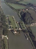 view gallery view galleryE7.6 km |  Wesel-Datteln-Kanal Schleuse Hünxe (km 13,317) Wesel-Datteln-Kanal Schleuse Hünxe (km 13,317)
in Waterway Locks, Planes and Lifts Länge Schleuse 1: 225 m / Schleuse 2: 112 m
Length Lock 1: 225 m / Lock 2: 112 m
Fallhöhe/Hight: 5,50 m
Kanal-km 13,317 posted by: diddler location: Nordrhein-Westfalen, Germany date approved: 09/15/2006 last visited: 06/12/2006 |
 view gallery view gallery S8.2 km S8.2 km
| Voerde - Germany in Train Stations/Depots There are two railway stations in Voerde (Lower Rhine) in the Wesel district: Voerde (Lower Rhine) and Friedrichsfeld (Lower Rhine). posted by: superstein location: Nordrhein-Westfalen, Germany date approved: 01/11/2018 last visited: 06/19/2022 |
 view gallery view gallerySE10.1 km | Golfclub Bruckmannshof in Public and Private Golf Courses 9 Hole Course, 3.940 m, PAR 64, Slope 113, CR 63.6
28 Range-Places (8 roofed) posted by: diddler location: Nordrhein-Westfalen, Germany date approved: 09/16/2006 last visited: 06/19/2022 |
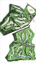 view gallery view gallerySE10.3 km | Golfclub Hünxerwald in Public and Private Golf Courses 18 Hole Course, Men PAR 72, 5903 m, Slope 122, Women PAR 73.9, 5182 m, Slope 122, 40 Driving Range Places, 6 Roofed, Crocker Golf System Academy posted by: diddler location: Nordrhein-Westfalen, Germany date approved: 09/11/2006 last visited: 09/11/2006 |
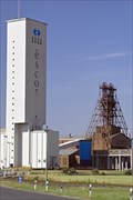 view gallery view gallerySW10.5 km |  Salzbergwerk Borth Salzbergwerk Borth
in Mines Das größte Salzbergwerk Europas mit einer Produktion von rund 2 Millionen Tonnen im Jahr.
The largest salt mine in Europe with a production of around 2 million tons a year. posted by: cache-catcher location: Nordrhein-Westfalen, Germany date approved: 07/07/2011 last visited: 08/30/2020 |
 view gallery view galleryW12.4 km |  Bislicher Insel Bislicher Insel
in Hiking and walking trailheads Die Bislicher Insel - eine der wenigen naturnahen Auenlandschaften am Niederrhein.
The Bislicher- island - one of the few natural floodplains in the Lower Rhine. posted by: cache-catcher location: Nordrhein-Westfalen, Germany date approved: 07/01/2011 last visited: 06/07/2015 |
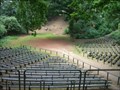 view gallery view galleryW14 km |  Amphitheater Xanten/Birten Amphitheater Xanten/Birten
in Ancient Roman Civilization römisches Amphitheater,
heute genutzt als Freilichtbühne
Roman amphitheater
now used as an open-air stage posted by: cache-catcher location: Nordrhein-Westfalen, Germany date approved: 06/26/2011 last visited: 06/27/2023 |
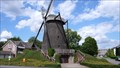
 view gallery view gallerySE14.2 km |  Hiesfelder Wind Mill - Dinslaken, Germany Hiesfelder Wind Mill - Dinslaken, Germany
in Deutsche Denkmallisten - German Monument Registers This wind mill is a monument since 4/4/1984 posted by: g300td location: Nordrhein-Westfalen, Germany date approved: 01/15/2015 last visited: 06/19/2022 |
 view gallery view gallerySE14.2 km |  Hiesfelder Wind Mill - Dinslaken, Germany Hiesfelder Wind Mill - Dinslaken, Germany
in Mills and Gins This wind mill is a monument since 4/4/1984 posted by: g300td location: Nordrhein-Westfalen, Germany date approved: 01/15/2015 last visited: 06/19/2022 |
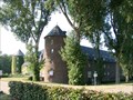 view gallery view gallerySW14.3 km |  Burg Winnenthal Burg Winnenthal
in Castles älteste Wasserburg des Niederrheins
oldest moated castle of the Lower Rhine posted by: cache-catcher location: Nordrhein-Westfalen, Germany date approved: 06/30/2011 last visited: 09/13/2012 |
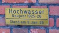 view gallery view galleryW14.8 km |  Rhein-Hochwasser 1925-1926, Lüttingen, Germany Rhein-Hochwasser 1925-1926, Lüttingen, Germany
in High Level Marks The high water level mark from 1/3/1926 posted by: g300td location: Nordrhein-Westfalen, Germany date approved: 12/09/2014 last visited: 06/26/2023 |
 view gallery view galleryW14.8 km |  Plane Crash in Lüttingen, Germany Plane Crash in Lüttingen, Germany
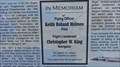
in Plane Crash Sites They gave their life to save ours.
This story gets under the skin. posted by: g300td location: Nordrhein-Westfalen, Germany date approved: 01/03/2015 last visited: 06/26/2023 |
 view gallery view galleryW14.8 km |  Plane Crash Memorial in Lüttingen, Germany Plane Crash Memorial in Lüttingen, Germany
in Disaster Memorials They gave their life to save ours. This story gets under the skin. posted by: g300td location: Nordrhein-Westfalen, Germany date approved: 12/15/2014 last visited: 06/26/2023 |
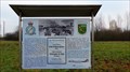
 view gallery view galleryW15 km |  Stadt- und Kirchengeschichte - 15 v. Chr. to 1966 - Xanten, NRW, Germany Stadt- und Kirchengeschichte - 15 v. Chr. to 1966 - Xanten, NRW, Germany
in Timelines Kleine Zeittafel zur Stadt- und Kirchengeschichte Xanten. --- Small timeline about the history of the town and church of Xanten. posted by: lumbricus location: Nordrhein-Westfalen, Germany date approved: 06/11/2015 last visited: 06/26/2023 |
 view gallery view galleryW15 km |  Historical Marker - Xanten, NRW, Germany Historical Marker - Xanten, NRW, Germany
in Way of St. James A historical marker near the cathedral in Xanten. posted by: lumbricus location: Nordrhein-Westfalen, Germany date approved: 06/10/2015 last visited: 08/13/2023 |
|