 view gallery view gallery NE0 km NE0 km
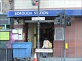
|   Borough Underground Station - Borough High Street, London, UK Borough Underground Station - Borough High Street, London, UK
in Wikipedia Entries Borough tube station, in south London, stands on the south west side of the road junction formed by Borough High Street and Marshalsea Road. The station opened in 1890. posted by:  Master Mariner Master Mariner location: London, United Kingdom date approved: 07/12/2014 last visited: never |
 view gallery view galleryNE0 km |  Borough Underground Station - Borough High Street, London, UK Borough Underground Station - Borough High Street, London, UK
in The Underground Borough tube station, in south London, stands on the south west side of the road junction formed by Borough High Street and Marshalsea Road. The station opened in 1890. posted by: Master Mariner location: London, United Kingdom date approved: 07/14/2014 last visited: never |
 view gallery view gallery S0 km S0 km
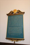
|  Reconsecration of St. Mary-le-Bow, Cheapside, London, UK Reconsecration of St. Mary-le-Bow, Cheapside, London, UK
in Grand Opening This plaque commemorates the 1964 re-consecration of St. Mary-le-Bow Church, which was rebuilt after being destroyed in WWII posted by:  Benchmark Blasterz Benchmark Blasterz location: London, United Kingdom date approved: 09/20/2016 last visited: 07/21/2016 |
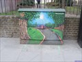
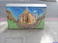 view gallery view galleryNE0 km |  St George the Martyr - Borough High Street - London, UK St George the Martyr - Borough High Street - London, UK
in Artistically Decorated Utility Boxes This utility box is on the north west side of Borough High Street opposite St George the Martyr church in south London. The artist has chosen to decorate the front of the box with an image of the church. posted by: Master Mariner location: London, United Kingdom date approved: 03/08/2015 last visited: never |
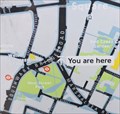
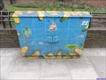
 view gallery view gallery SW0 km SW0 km
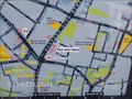
|  You Are Here - Borough High Street, London, UK You Are Here - Borough High Street, London, UK
in 'You Are Here' Maps This map is at a docking station for "Boris Bikes", more properly known as Barclay Bikes. This docking station is the north west side of Borough High Street. posted by: Master Mariner location: London, United Kingdom date approved: 04/12/2014 last visited: never |
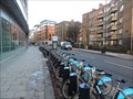
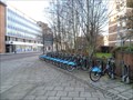 view gallery view gallerySW0 km |  The Borough - Borough High Street, London, UK The Borough - Borough High Street, London, UK
in Bicycle Rentals A docking station for "Boris Bikes", more properly known as Barclay Bikes. This docking station is on the north west side of Borough High Street. posted by: Master Mariner location: London, United Kingdom date approved: 04/14/2014 last visited: never |
 view gallery view galleryNE0.2 km | Sugar Cane - Borough High Street, London, UK in Artistically Decorated Utility Boxes This utility box is on the south east side of Borough High Street at the junction with Tabard Street near St George the Martyr church. The main image is of sugar cane. posted by: Master Mariner location: London, United Kingdom date approved: 03/23/2015 last visited: never |
 view gallery view galleryNE0.2 km | Little Dorrit Park - Borough High Street, London, UK in Artistically Decorated Utility Boxes This utility box is on the north west side of Borough High Street outside Little Dorrit Park. The artist has chosen to decorate it with a picture of the park and the children's play area. posted by: Master Mariner location: London, United Kingdom date approved: 03/08/2015 last visited: never |
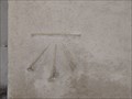
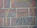
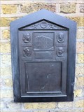
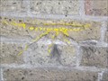
 view gallery view galleryS0.2 km |  Cut Bench Mark & Bolt - Swan Street, London, UK Cut Bench Mark & Bolt - Swan Street, London, UK
in U.K. and Ireland Trigpoints This mark is cut into the brickwork of a building at the junction of Swan Street and Trinity Church Square. The mark is cut into the Swan Street face of the building. posted by: Master Mariner location: London, United Kingdom date approved: 03/23/2015 last visited: never |
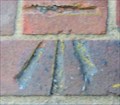
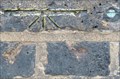 view gallery view galleryS0.2 km |  Cut Bench Mark & Bolt - Swan Street, London, UK Cut Bench Mark & Bolt - Swan Street, London, UK
in European Historic Survey Stones, Monuments and Benchmarks This mark is cut into the brickwork of a building at the junction of Swan Street and Trinity Church Square. The mark is cut into the Swan Street face of the building. posted by: Master Mariner location: London, United Kingdom date approved: 03/25/2015 last visited: never |
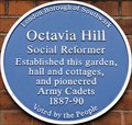 view gallery view gallery N0.2 km N0.2 km
|  Octavia Hill - Red Cross Way, London, UK Octavia Hill - Red Cross Way, London, UK
in Blue Plaques This blue plaque, erected on a building at the rear of Red Cross Gardens, indicates that Octavia Hill "established this garden, hall and cottages". The garden is on the north west side of Redcross Way in London. posted by: Master Mariner location: London, United Kingdom date approved: 09/01/2015 last visited: never |
 view gallery view gallerySW0.2 km | Cut Bench Mark - Borough High Street, London, UK in U.K. and Ireland Trigpoints This mark is cut into the stone face of a police station on the south east side of Borough High Street. posted by: Master Mariner location: London, United Kingdom date approved: 07/11/2014 last visited: never |
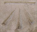 view gallery view gallerySW0.2 km | Cut Bench Mark - Borough High Street, London, UK in European Historic Survey Stones, Monuments and Benchmarks This mark is cut into the stone face of a police station on the south east side of Borough High Street. posted by: Master Mariner location: London, United Kingdom date approved: 07/16/2014 last visited: never |
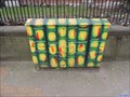
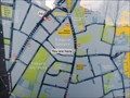
 view gallery view gallery NW0.3 km NW0.3 km
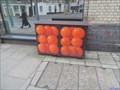
| Orange Box - Marshalsea Road, London, UK in Artistically Decorated Utility Boxes This utility box is on the north east side of Marshalsea Road at the junction with Southwark Bridge Road. The box has been decorated to look like two crates of oranges. posted by: Master Mariner location: London, United Kingdom date approved: 03/20/2015 last visited: never |
 view gallery view galleryNW0.3 km | You Are Here - Southwark Bridge Road, London, UK in 'You Are Here' Maps This "you are here" map is on the south east side of Southwark Bridge Road at the junction with Marshalsea Road. posted by: Master Mariner location: London, United Kingdom date approved: 09/01/2015 last visited: never |
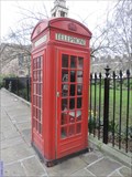 view gallery view galleryS0.3 km |  Red Telephone Box - Trinity Church Square, London, UK Red Telephone Box - Trinity Church Square, London, UK
in Red Telephone Boxes This red telephone box is located at the east corner of Trinity Church Square near the junction with Trinity Street. posted by: Master Mariner location: London, United Kingdom date approved: 09/01/2015 last visited: never |
 view gallery view gallery E0.3 km E0.3 km
| Cut Bench Mark - Long Lane, London, UK in U.K. and Ireland Trigpoints This mark is cut into brickwork at the south west corner of Balin House on the north side of Long Lane. The building is surrounded by provate gardens but the mark can be seen from the adjacent public footpath in Long Lane. posted by: Master Mariner location: London, United Kingdom date approved: 07/11/2014 last visited: never |
 view gallery view galleryE0.3 km | Cut Bench Mark - Long Lane, London, UK in European Historic Survey Stones, Monuments and Benchmarks This mark is cut into brickwork at the south west corner of Balin House on the north side of Long Lane. The building is surrounded by provate gardens but the mark can be seen from the adjacent public footpath in Long Lane. posted by: Master Mariner location: London, United Kingdom date approved: 07/16/2014 last visited: never |
 view gallery view galleryE0.3 km | Banana Map - Long Lane, London, UK in Artistically Decorated Utility Boxes This utility box is on the north east side of Long Lane close to a bus stop. The main image is a nautical chart surrounded by... bananas. posted by: Master Mariner location: London, United Kingdom date approved: 03/23/2015 last visited: never |
 view gallery view galleryNW0.3 km |  Evelina Children's Hospital - Southwark Bridge Road, London UK Evelina Children's Hospital - Southwark Bridge Road, London UK
in UK Historical Markers This plaque, at the junction of Southwark Bridge Road and Quilp Street, marks the location where the Evelina Children's Hospital stood from 1869 to 1976. posted by: Master Mariner location: London, United Kingdom date approved: 04/28/2012 last visited: never |
 view gallery view galleryE0.3 km | You Are Here - Empire Square, London, UK in 'You Are Here' Maps This map is at a docking station for "Boris Bikes", more properly known as Barclay Bikes. This docking station is on the south side of Long Lane. posted by: Master Mariner location: London, United Kingdom date approved: 04/12/2014 last visited: never |
 view gallery view galleryE0.3 km | The Borough - Empire Square, London, UK in Bicycle Rentals A docking station for "Boris Bikes", more properly known as Barclay Bikes. This docking station is on the south side of Long Lane. posted by: Master Mariner location: London, United Kingdom date approved: 04/14/2014 last visited: never |
 view gallery view galleryNW0.3 km | Welsh Congregational Chapel - Southwark Bridge Road, London, UK in Wikipedia Entries The original Borough Welsh Congregational Chapel opened on this site in 1806. The existing building dates from 1872. posted by: Master Mariner location: London, United Kingdom date approved: 04/28/2012 last visited: never |
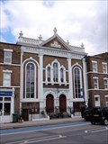 view gallery view galleryNW0.3 km |  Welsh Congregational Chapel - Southwark Bridge Road, London, UK Welsh Congregational Chapel - Southwark Bridge Road, London, UK
in This Old Church The original Borough Welsh Congregational Chapel opened on this site in 1806. The existing building dates from 1872. posted by: Master Mariner location: London, United Kingdom date approved: 04/28/2012 last visited: never |
 view gallery view galleryNW0.3 km | Cut Bench Mark - Quilp Street, London, UK in U.K. and Ireland Trigpoints This mark is cut into a wall at the junction of Quilp Street and Southwark Bridge Road. A plaque is also located on the wall commemorating a hospital that stood close by. posted by: Master Mariner location: London, United Kingdom date approved: 04/22/2012 last visited: never |
|