 view gallery view gallery W0.8 km W0.8 km
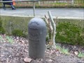
|   London County Council Boundary Post, Oxleas Woods. London. UK London County Council Boundary Post, Oxleas Woods. London. UK
in Public Land Survey Marks This boundary marker is one of several in the close vicinity posted by:  dave-harris dave-harris location: South East England, United Kingdom date approved: 02/04/2013 last visited: 12/18/2020 |
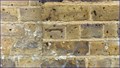
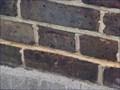
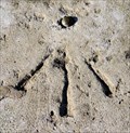
 view gallery view galleryW0.8 km |  Cut Bench Mark with Rivet - Welling Way, London, UK Cut Bench Mark with Rivet - Welling Way, London, UK
in U.K. and Ireland Trigpoints This rivet and cut mark are on top of a small wall that runs alongside a path leading north, from Welling Way, into Oxleas Wood. posted by:  Master Mariner Master Mariner location: London, United Kingdom date approved: 02/09/2013 last visited: never |
 view gallery view gallery E1 km E1 km
|  Welling - Russian 36 pounder carronade Welling - Russian 36 pounder carronade
in Static Artillery Displays A trophy of the Crimean War. posted by: Master Mariner location: South East England, United Kingdom date approved: 05/08/2011 last visited: 03/02/2021 |
 view gallery view gallery NW1.1 km NW1.1 km
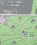
|  You Are Here - Oxleas Wood You Are Here - Oxleas Wood
in 'You Are Here' Maps You are here... At an entrance to Oxleas Woods. posted by: Master Mariner location: London, United Kingdom date approved: 05/01/2011 last visited: 05/14/2011 |
 view gallery view galleryW1.3 km | You Are Here, Oxleas Woods, London. UK in 'You Are Here' Maps The most southerly entrance to this ancient woodland posted by: dave-harris location: South East England, United Kingdom date approved: 02/02/2013 last visited: 02/09/2013 |
 view gallery view gallery SW1.4 km SW1.4 km
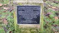
|  Twin Towns - Greenwich (UK) & Reinickendorf (Germany) Twin Towns - Greenwich (UK) & Reinickendorf (Germany)
in Sister City Monuments A stone with plaque mounted on it. posted by: Master Mariner location: London, United Kingdom date approved: 05/01/2011 last visited: 08/27/2011 |
 view gallery view gallery N1.8 km N1.8 km
| Cut Bench Mark - Woolwich New Cemetery, Camdale Road, London, UK in U.K. and Ireland Trigpoints A bench mark cut in the wall of Woolwich New Cemetery. posted by: Master Mariner location: London, United Kingdom date approved: 10/07/2011 last visited: never |
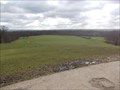 view gallery view galleryNW1.8 km |  Oxleas Meadows, Shooters Hill, London. UK Oxleas Meadows, Shooters Hill, London. UK
in Scenic Overlooks On a clear day you can see for miles at this useful beauty spot posted by: dave-harris location: South East England, United Kingdom date approved: 02/03/2013 last visited: 02/09/2013 |
 view gallery view galleryNW1.8 km | You Are Here, Oxleas Meadows, South East London. UK in 'You Are Here' Maps Visit this place and you are looking at 8000 years on ancient woodland posted by: dave-harris location: South East England, United Kingdom date approved: 02/02/2013 last visited: 06/23/2013 |
 view gallery view galleryNW1.8 km | Cut Bench Mark - Oxleas Meadow, Shooters Hill, London, UK in U.K. and Ireland Trigpoints This mark is cut into brick at the northern corner of the toilet block building at the top end of Oxleas Meadow in south east London. posted by: Master Mariner location: London, United Kingdom date approved: 02/09/2013 last visited: never |
 view gallery view galleryE1.8 km |  Danson House - Danson Park, London, UK Danson House - Danson Park, London, UK
in Pre-Victorian Historic Homes Danson House is a large, Georgian House built c1766 for Sir John Boyd. At the time of construction it was known as Danson Hill. The house stands near the centre of Danson Park and is now used for public functions. posted by: Master Mariner location: London, United Kingdom date approved: 01/02/2016 last visited: 02/24/2021 |
 view gallery view galleryE1.8 km |  Danson House - Danson Park, London, UK Danson House - Danson Park, London, UK
in Wikipedia Entries Danson House is a large, Georgian House built c1766 for Sir John Boyd. At the time of construction it was known as Danson Hill. The house stands near the centre of Danson Park and is now used for public functions. posted by: Master Mariner location: London, United Kingdom date approved: 12/29/2015 last visited: never |
 view gallery view galleryE1.8 km |  Danson House - Danson Park, London, UK Danson House - Danson Park, London, UK
in Satellite Imagery Oddities Danson House is a large, Georgian House built c1766 for Sir John Boyd. At the time of construction it was known as Banson Hill. The house stands near the centre of Danson Park and is now used for public functions. posted by: Master Mariner location: London, United Kingdom date approved: 12/30/2015 last visited: never |
 view gallery view galleryNW1.8 km | Oxleas Woods - Shooters Hill, London, UK in Wikipedia Entries Oxleas Wood is an ancient woodland, around 8000 years old, located in south east London just to the south of Shooters Hill and the old Roman Road known as Watling Street. posted by: Master Mariner location: London, United Kingdom date approved: 02/10/2013 last visited: 12/18/2020 |
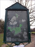 view gallery view galleryNW1.8 km |  Oxleas Woodlands - Oxleas Meadow, Shooters Hill, London, UK Oxleas Woodlands - Oxleas Meadow, Shooters Hill, London, UK
in Flora and Fauna Information Signs Oxleas Woodlands is designated a Site of Special Interest and this information board explains why. posted by: Master Mariner location: London, United Kingdom date approved: 02/13/2013 last visited: never |
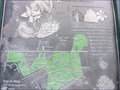 view gallery view galleryNW1.8 km | You Are Here - Oxleas Meadow, Shooters Hill, London, UK in 'You Are Here' Maps This map/information board is located at the southern end of the path leading from the car park to Oxleas Meadow. posted by: Master Mariner location: London, United Kingdom date approved: 02/09/2013 last visited: never |
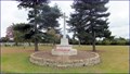 view gallery view galleryN1.9 km |  Woolwich Cemetery World War I Memorial - Camdale Road. Plumstead, London, UK Woolwich Cemetery World War I Memorial - Camdale Road. Plumstead, London, UK
in World War I Memorials and Monuments A generic World War I memorial in the new part of Woolwich Cemetery. posted by: Master Mariner location: London, United Kingdom date approved: 10/15/2011 last visited: never |
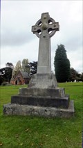 view gallery view galleryN1.9 km |  Princess Alice Memorial - Woolwich Cemetery, Camdale Road, Plumstead, London, UK Princess Alice Memorial - Woolwich Cemetery, Camdale Road, Plumstead, London, UK
in Disaster Memorials The pleasure steamer "Princess Alice" collided with a collier, the "Bywell Castle" that resulted in hundreds losing their lives to drowning or the ingestion of polluted river water. posted by: Master Mariner location: London, United Kingdom date approved: 12/02/2011 last visited: never |
 view gallery view galleryNW1.9 km |  Shooter's Hill Water Tower - South East London Shooter's Hill Water Tower - South East London
in Water Towers A gothic tower dominating the skyline. posted by: Master Mariner location: London, United Kingdom date approved: 04/30/2011 last visited: 12/18/2020 |
 view gallery view galleryNW1.9 km | Water Tower - Shooters Hill, South East London, UK in Satellite Imagery Oddities A gothic tower dominating the skyline of south east London. posted by: Master Mariner location: London, United Kingdom date approved: 01/11/2013 last visited: never |
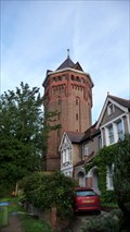 view gallery view galleryNW1.9 km |  Water Tower - Shooters Hill, South East London, UK Water Tower - Shooters Hill, South East London, UK
in Octagon Buildings This eight-sided gothic water tower dominates the skyline of south east London. posted by: Master Mariner location: London, United Kingdom date approved: 01/11/2013 last visited: never |
 view gallery view galleryN1.9 km | Woolwich Cemetery Chapel - Camdale Road, London, UK in U.K. and Ireland Trigpoints A cut bench mark in Woolwich Cemetery. posted by: Master Mariner location: London, United Kingdom date approved: 10/07/2011 last visited: never |
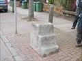
 view gallery view galleryE1.9 km |  Cut Mark and Rivet - Park View Road, London, UK Cut Mark and Rivet - Park View Road, London, UK
in European Historic Survey Stones, Monuments and Benchmarks The cut mark and rivet are on top of a stone on the south west side of Park View Road. The stone may, at some time, have been a milepost of boundary marker but there are no visible inscriptions. posted by: Master Mariner location: London, United Kingdom date approved: 01/17/2016 last visited: never |
 view gallery view galleryE1.9 km | Cut Mark and Rivet - Park View Road, London, UK in U.K. and Ireland Trigpoints The cut mark and rivet are on top of a stone on the south west side of Park View Road. The stone may, at some time, have been a milepost of boundary marker but there are no visible inscriptions. posted by: Master Mariner location: London, United Kingdom date approved: 01/14/2016 last visited: 02/24/2021 |
 view gallery view galleryNW2.1 km |  Mounting Block, Shooters Hill, London. UK Mounting Block, Shooters Hill, London. UK
in Historic Upping Stones, Hitching Posts, and Carriage Blocks This mounting block sits beside the main road at the top of Shooters Hill in London. UK posted by: dave-harris location: South East England, United Kingdom date approved: 02/02/2013 last visited: 12/18/2020 |
|