 view gallery view gallery SW9.3 km SW9.3 km
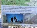
|   UTM 433020 5659619 - Parkplatz Hohe Bracht, Lennestadt, NRW, Germany UTM 433020 5659619 - Parkplatz Hohe Bracht, Lennestadt, NRW, Germany
in Permanent Geographic Coordinates DE: Auf dem Wanderparkplatz am Aussichtsturm "Hohe Bracht" befindet sich eine Übersichtskarte mit UTM-Koordinaten.
EN: There is an overview map with UTM coordinates on the hiking car park at the "Hohe Bracht" lookout tower. posted by:  FamilieFrohne FamilieFrohne location: Nordrhein-Westfalen, Germany date approved: 07/22/2022 last visited: never |
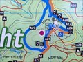 view gallery view gallerySW9.3 km |  Standort Parkplatz Hohe Bracht - Lennestadt, NRW, Germany Standort Parkplatz Hohe Bracht - Lennestadt, NRW, Germany
in 'You Are Here' Maps DE: Auf dem Wanderparkplatz am Aussichtsturm "Hohe Bracht" befindet sich eine Übersichtskarte mit Standortinformation.
EN: There is an overview map with location information on the hiking car park at the "Hohe Bracht" lookout tower. posted by: FamilieFrohne location: Nordrhein-Westfalen, Germany date approved: 07/12/2022 last visited: never |
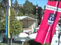
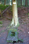
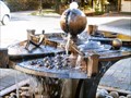 view gallery view gallery NE13 km NE13 km
|  Bad Fredeburg Bad Fredeburg
in Fountains a small little fountain in Bad Fredeburg, Germany posted by:  TeamAstelix TeamAstelix location: Nordrhein-Westfalen, Germany date approved: 11/28/2005 last visited: 09/17/2017 |
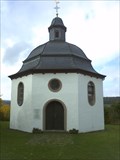 view gallery view gallery W15.4 km W15.4 km
|  Marienkapelle Oberveischede - Gernamany - North Rhine/Westfalia Marienkapelle Oberveischede - Gernamany - North Rhine/Westfalia
in Octagon Buildings DE: Kapelle `Unserer lieben Frau vom Rennenberg` in Oberveischede.
EN: Chapel `Unserer lieben Frau vom Rennenberg` in Oberveischede. posted by: ColleIsarco location: Nordrhein-Westfalen, Germany date approved: 11/14/2013 last visited: 02/10/2013 |
 view gallery view gallery SE17.5 km SE17.5 km
|  750 Jahrfeier Bad Berleburg 750 Jahrfeier Bad Berleburg
in Web Cameras Webcam zur 750 jahrfeier der Stadt Bad Berleburg posted by: Beardieteam location: Nordrhein-Westfalen, Germany date approved: 09/03/2008 last visited: 10/05/2015 |
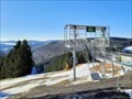 view gallery view gallery E22.2 km E22.2 km
|  Astenkick - Altastenberg, NRW, Germany Astenkick - Altastenberg, NRW, Germany
in Zip-line DE: In Altastenberg im Sauerland befindet sich die zweitlängste Zip-Line Europas.
EN: The second longest zip line in Europe is located in Altastenberg in Sauerland. posted by: FamilieFrohne location: Nordrhein-Westfalen, Germany date approved: 03/05/2022 last visited: 07/22/2022 |
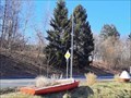 view gallery view galleryW22.2 km |  Kleines Segelboot - Sondern bei Olpe, NRW, Germany Kleines Segelboot - Sondern bei Olpe, NRW, Germany
in Landlocked Boats DE: Ein zum Blumenkübel umfunktioniertes Segelboot findet sich in Sondern beim Restaurant see:sicht.
EN: A sailing boat that has been converted into a flower pot can be found in Sondern at the see:sicht restaurant. posted by: FamilieFrohne location: Nordrhein-Westfalen, Germany date approved: 03/03/2022 last visited: never |
 view gallery view gallery S22.9 km S22.9 km
|  Origin - Sieg River Origin - Sieg River
in River Origins, Destinations and Confluences Die Quelle der Sieg liegt im südlichen Rothaargebirge | The origin of the of the river Sieg lies in the southern part of the Rothaargebirge posted by: Eibacher Kuckuck location: Nordrhein-Westfalen, Germany date approved: 04/02/2015 last visited: 08/26/2016 |
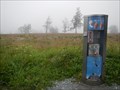
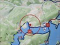 view gallery view galleryW23 km | Standort Listermauer - Attendorn, NRW, Germany in 'You Are Here' Maps DE: Nahe der Staumauer der Lister-Talsperre befindet sich auch eine Standorttafel.
EN: There is also a location board near the dam wall of the Lister dam. posted by: FamilieFrohne location: Nordrhein-Westfalen, Germany date approved: 03/01/2022 last visited: never |
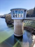 view gallery view galleryW23.2 km |  Listerkraftwerk - Attendorn, NRW, Germany Listerkraftwerk - Attendorn, NRW, Germany
in Hydroelectric Power Stations DE: Das Listerkraftwerk war eines der ersten, das zur Erzeugung von elektrischem Strom im Sauerland genutzt wurde.
EN: The Lister power plant was one of the first to be used to generate electricity in the Sauerland. posted by: FamilieFrohne location: Nordrhein-Westfalen, Germany date approved: 03/02/2022 last visited: never |
 view gallery view galleryW23.2 km |  20 - Attendorn - DE - Radnetz Südwestfalen 20 - Attendorn - DE - Radnetz Südwestfalen
in Cycling Routes DE: Direkt am südlichen Ende der Lister-Sperrmauer befindet sich der Knotenpunkt 20 des Radnetzes Südwestfalen.
EN: Junction 20 of the South Westphalia Cycle Network is located directly at the southern end of the Lister dam. posted by: FamilieFrohne location: Nordrhein-Westfalen, Germany date approved: 03/03/2022 last visited: never |
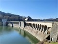 view gallery view galleryW23.2 km |  Sperrmauer Listertalsperre - Attendorn, NRW, Germany Sperrmauer Listertalsperre - Attendorn, NRW, Germany
in Water Dams DE: Die 40m hohe Sperrmauer der Listertalsperre bei Attendorn staut das Wasser seit 1912.
EN: The 40m high water dam of the Listertalsperre near Attendorn has been damming the water since 1912. posted by: FamilieFrohne location: Nordrhein-Westfalen, Germany date approved: 02/28/2022 last visited: never |
 view gallery view gallery NW23.2 km NW23.2 km
|  Polizeiwache Plettenberg, Am Wall, Plettenberg Polizeiwache Plettenberg, Am Wall, Plettenberg
in Police Stations Derzeitige Polizeiwache in Plettenberg posted by: Dorfsheriff location: Nordrhein-Westfalen, Germany date approved: 11/25/2010 last visited: 02/09/2019 |
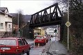 view gallery view galleryNW23.2 km |  Kreisverkehr "Schwarze Brücke" in Plettenberg, Germany Kreisverkehr "Schwarze Brücke" in Plettenberg, Germany
in Railroad Bridges Ehemaliger Standort einer Eisenbahnbrücke der Werksstrecke Plettenberg-Eiringhausen nach Plettenberg-Oberstadt posted by: Dorfsheriff location: Nordrhein-Westfalen, Germany date approved: 11/24/2010 last visited: 02/09/2019 |
 view gallery view galleryE23.2 km | ORIGIN: Lenne - Winterberg, NRW, Germany in River Origins, Destinations and Confluences DE: Die Lenne entspringt in der Nähe des Kahlen Astens bei Winterberg.
EN: The Lenne has its source near the Kahler Asten near Winterberg. posted by: FamilieFrohne location: Nordrhein-Westfalen, Germany date approved: 05/27/2022 last visited: 07/22/2022 |
 view gallery view galleryE23.5 km |  Kahler Asten Penny Smasher Kahler Asten Penny Smasher
in Penny Smashers Near the weather station on top of the Kahler Asten there's this penny smasher. posted by: naj16 location: Nordrhein-Westfalen, Germany date approved: 07/27/2014 last visited: 09/22/2017 |
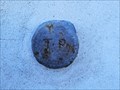 view gallery view galleryE23.5 km |  TP - Astenturm - Winterberg, NRW, Germany TP - Astenturm - Winterberg, NRW, Germany
in German Trigonometric Points DE: Ein nicht mehr genutzter TP-Bolzen befindet sich am Astenturm auf dem Kahlen Asten.
EN: A TP bolt that is no longer used is located at the Astenturm on the Kahler Asten. posted by: FamilieFrohne location: Nordrhein-Westfalen, Germany date approved: 03/25/2022 last visited: 07/22/2022 |
 view gallery view galleryE23.5 km | Standort Parkplatz Kahler Asten - Winterberg, NRW, Germany in 'You Are Here' Maps DE: Am Wanderparkplatz am Kahlen Asten nahe Winterberg befindet sich auch eine Übersichtskarte mit Standortinformation.
EN: There is also an overview map with location information at the Kahlen Asten hiking car park near Winterberg. posted by: FamilieFrohne location: Nordrhein-Westfalen, Germany date approved: 05/25/2022 last visited: never |
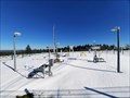 view gallery view galleryE23.5 km |  Wetterstation Kahler Asten - Winterberg, NRW, Germany Wetterstation Kahler Asten - Winterberg, NRW, Germany
in Weather Stations DE: Der deutsche Wetterdienst betreibt am Kahlen Asten eine Wetterstation.
EN: The German Weather Service operates a weather station at Kahler Asten. posted by: FamilieFrohne location: Nordrhein-Westfalen, Germany date approved: 03/21/2022 last visited: 07/22/2022 |
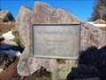
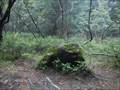 view gallery view galleryE23.7 km |  Blutstein, Winterberg - Germany Blutstein, Winterberg - Germany
in European Historic Survey Stones, Monuments and Benchmarks Next to the Rothaarsteig you can find this old boundary stone. posted by: naj16 location: Nordrhein-Westfalen, Germany date approved: 07/27/2014 last visited: 12/06/2021 |
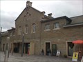 view gallery view galleryNW24.3 km |  Plettenberg Eiringhausen Plettenberg Eiringhausen
in Train Stations/Depots Train-Station Plettenberg Eiringhausen posted by: snowcacher location: Nordrhein-Westfalen, Germany date approved: 11/15/2010 last visited: 02/09/2019 |
 view gallery view galleryS25.6 km | ORIGIN - Lahn River in River Origins, Destinations and Confluences Die Lahn entspringt in einem kleinen Teich in Lahnhof, einem Ortsteil der Stadt Netphen | The Lahn has its source in a small pond in Lahnhof. posted by: Eibacher Kuckuck location: Nordrhein-Westfalen, Germany date approved: 10/20/2014 last visited: 10/05/2015 |
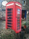 view gallery view galleryNW26.6 km |  Rote Telefonzelle in Altenaffeln, Sauerland Rote Telefonzelle in Altenaffeln, Sauerland
in Red Telephone Boxes Eine rote Telefonzelle ohne Telefon zu Deko-Zwecken posted by: Dorfsheriff location: Nordrhein-Westfalen, Germany date approved: 01/17/2011 last visited: 01/23/2011 |
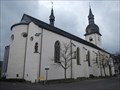 view gallery view gallery N26.7 km N26.7 km
|  St. Walburga, Meschede, Deutschland St. Walburga, Meschede, Deutschland
in Roman Catholic Churches St. Walburga is an old roman-catholic church in the centre of Meschede posted by: Becktracker location: Nordrhein-Westfalen, Germany date approved: 02/19/2020 last visited: 12/11/2021 |
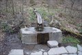
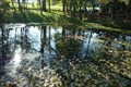
 view gallery view galleryS27 km |  Heilige Ilsequelle - Heiligenborn, NRW, Germany Heilige Ilsequelle - Heiligenborn, NRW, Germany
in Holy Wells Als heilige Ilse-Quelle war diese Quelle bereits im Mittelalter bekannt, ihrem Wasser wurden heilsame Kräfte zugeschrieben. | This holy well was already known in the Middle Ages. Healing powers were attributed to its water. posted by: Eibacher Kuckuck location: Nordrhein-Westfalen, Germany date approved: 10/20/2014 last visited: 11/15/2021 |
|