 view gallery view gallery N8.5 km N8.5 km
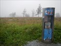
|   Bad Fredeburg Bad Fredeburg
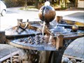
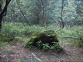
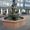
in Fountains a small little fountain in Bad Fredeburg, Germany posted by:  TeamAstelix TeamAstelix location: Nordrhein-Westfalen, Germany date approved: 11/28/2005 last visited: 09/17/2017 |
 view gallery view gallery SE9.7 km SE9.7 km
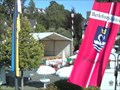
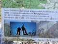
|  750 Jahrfeier Bad Berleburg 750 Jahrfeier Bad Berleburg
in Web Cameras Webcam zur 750 jahrfeier der Stadt Bad Berleburg posted by: Beardieteam location: Nordrhein-Westfalen, Germany date approved: 09/03/2008 last visited: 10/05/2015 |
 view gallery view gallery NE14 km NE14 km
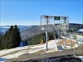
|  Astenkick - Altastenberg, NRW, Germany Astenkick - Altastenberg, NRW, Germany
in Zip-line DE: In Altastenberg im Sauerland befindet sich die zweitlängste Zip-Line Europas.
EN: The second longest zip line in Europe is located in Altastenberg in Sauerland. posted by:  FamilieFrohne FamilieFrohne location: Nordrhein-Westfalen, Germany date approved: 03/05/2022 last visited: 07/22/2022 |
 view gallery view galleryNE14.6 km |  ORIGIN: Lenne - Winterberg, NRW, Germany ORIGIN: Lenne - Winterberg, NRW, Germany
in River Origins, Destinations and Confluences DE: Die Lenne entspringt in der Nähe des Kahlen Astens bei Winterberg.
EN: The Lenne has its source near the Kahler Asten near Winterberg. posted by: FamilieFrohne location: Nordrhein-Westfalen, Germany date approved: 05/27/2022 last visited: 07/22/2022 |
 view gallery view galleryNE14.8 km |  Kahler Asten Penny Smasher Kahler Asten Penny Smasher
in Penny Smashers Near the weather station on top of the Kahler Asten there's this penny smasher. posted by: naj16 location: Nordrhein-Westfalen, Germany date approved: 07/27/2014 last visited: 09/22/2017 |
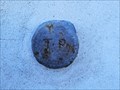 view gallery view galleryNE14.8 km |  TP - Astenturm - Winterberg, NRW, Germany TP - Astenturm - Winterberg, NRW, Germany
in German Trigonometric Points DE: Ein nicht mehr genutzter TP-Bolzen befindet sich am Astenturm auf dem Kahlen Asten.
EN: A TP bolt that is no longer used is located at the Astenturm on the Kahler Asten. posted by: FamilieFrohne location: Nordrhein-Westfalen, Germany date approved: 03/25/2022 last visited: 07/22/2022 |
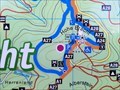
 view gallery view galleryNE14.8 km |  Standort Parkplatz Kahler Asten - Winterberg, NRW, Germany Standort Parkplatz Kahler Asten - Winterberg, NRW, Germany
in 'You Are Here' Maps DE: Am Wanderparkplatz am Kahlen Asten nahe Winterberg befindet sich auch eine Übersichtskarte mit Standortinformation.
EN: There is also an overview map with location information at the Kahlen Asten hiking car park near Winterberg. posted by: FamilieFrohne location: Nordrhein-Westfalen, Germany date approved: 05/25/2022 last visited: never |
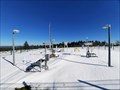 view gallery view galleryNE15 km |  Wetterstation Kahler Asten - Winterberg, NRW, Germany Wetterstation Kahler Asten - Winterberg, NRW, Germany
in Weather Stations DE: Der deutsche Wetterdienst betreibt am Kahlen Asten eine Wetterstation.
EN: The German Weather Service operates a weather station at Kahler Asten. posted by: FamilieFrohne location: Nordrhein-Westfalen, Germany date approved: 03/21/2022 last visited: 07/22/2022 |
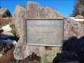
 view gallery view galleryNE15.1 km |  Blutstein, Winterberg - Germany Blutstein, Winterberg - Germany
in European Historic Survey Stones, Monuments and Benchmarks Next to the Rothaarsteig you can find this old boundary stone. posted by: naj16 location: Nordrhein-Westfalen, Germany date approved: 07/27/2014 last visited: 12/06/2021 |
 view gallery view gallery W18.3 km W18.3 km
|  UTM 433020 5659619 - Parkplatz Hohe Bracht, Lennestadt, NRW, Germany UTM 433020 5659619 - Parkplatz Hohe Bracht, Lennestadt, NRW, Germany
in Permanent Geographic Coordinates DE: Auf dem Wanderparkplatz am Aussichtsturm "Hohe Bracht" befindet sich eine Übersichtskarte mit UTM-Koordinaten.
EN: There is an overview map with UTM coordinates on the hiking car park at the "Hohe Bracht" lookout tower. posted by: FamilieFrohne location: Nordrhein-Westfalen, Germany date approved: 07/22/2022 last visited: never |
 view gallery view galleryW18.3 km | Standort Parkplatz Hohe Bracht - Lennestadt, NRW, Germany in 'You Are Here' Maps DE: Auf dem Wanderparkplatz am Aussichtsturm "Hohe Bracht" befindet sich eine Übersichtskarte mit Standortinformation.
EN: There is an overview map with location information on the hiking car park at the "Hohe Bracht" lookout tower. posted by: FamilieFrohne location: Nordrhein-Westfalen, Germany date approved: 07/12/2022 last visited: never |
 view gallery view galleryNE20.9 km | ORIGIN - Ruhr River, Germany in River Origins, Destinations and Confluences Near Winterberg you can find the source of the river Ruhr. posted by: naj16 location: Nordrhein-Westfalen, Germany date approved: 07/27/2014 last visited: 08/16/2017 |
 view gallery view gallery S22.2 km S22.2 km
| Altstadtbrunnen - Bad Laasphe, NRW, Germany in Fountains This fountain was set up in 1994 near the Stadtkirche. It depicts scenes of the history of Bad Laasphe posted by: Eibacher Kuckuck location: Nordrhein-Westfalen, Germany date approved: 01/15/2017 last visited: never |
 view gallery view galleryS22.2 km |  Evangelische Stadtkirche - Bad Laasphe, NRW, Germany Evangelische Stadtkirche - Bad Laasphe, NRW, Germany
in Medieval Churches The Protestant Church in Bad Laasphe was built in the early 13th century and is the oldest preserved building in the town posted by: Eibacher Kuckuck location: Nordrhein-Westfalen, Germany date approved: 01/14/2017 last visited: never |
 view gallery view galleryS22.2 km | Origin - Sieg River in River Origins, Destinations and Confluences Die Quelle der Sieg liegt im südlichen Rothaargebirge | The origin of the of the river Sieg lies in the southern part of the Rothaargebirge posted by: Eibacher Kuckuck location: Nordrhein-Westfalen, Germany date approved: 04/02/2015 last visited: 08/26/2016 |
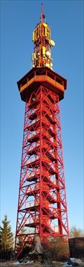 view gallery view galleryN24 km |  Stüppelturm Stüppelturm
in Look-Out Towers Der Stüppelturm ist ein Aussichtturm, der schon aus der Ferne zu erkennen ist. posted by: rennschnecke60 location: Nordrhein-Westfalen, Germany date approved: 03/07/2022 last visited: never |
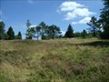 view gallery view galleryNE24.1 km |  Die Niedersfelder Hochheide Die Niedersfelder Hochheide
in Scenic Overlooks Die Niedersfelder Hochheide liegt in dem Naturschutzgebiet Neuer Hagen am Nordhang des 839m hohen Clemensberges. Hier liegt eine einzigartige Heidelandschaft mit Hochmoorgebiet mit einer seltenen Tier- und Pflanzenwelt. posted by: Hide*seek location: Nordrhein-Westfalen, Germany date approved: 05/10/2014 last visited: 11/08/2021 |
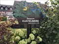 view gallery view galleryNE24.1 km |  Weser-Rhein-Wasserscheide - Medebach-Küstelberg, NRW, D Weser-Rhein-Wasserscheide - Medebach-Küstelberg, NRW, D
in Watershed Markers and Monuments Watershed between Rhine and Weser marked on a wood carving in Küstelberg, township of Medebach in the Hochsauerland region. posted by: André de Montbard location: Nordrhein-Westfalen, Germany date approved: 09/22/2018 last visited: never |
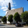
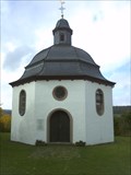 view gallery view galleryW24.6 km |  Marienkapelle Oberveischede - Gernamany - North Rhine/Westfalia Marienkapelle Oberveischede - Gernamany - North Rhine/Westfalia
in Octagon Buildings DE: Kapelle `Unserer lieben Frau vom Rennenberg` in Oberveischede.
EN: Chapel `Unserer lieben Frau vom Rennenberg` in Oberveischede. posted by: ColleIsarco location: Nordrhein-Westfalen, Germany date approved: 11/14/2013 last visited: 02/10/2013 |
 view gallery view galleryS25.1 km | ORIGIN - Lahn River in River Origins, Destinations and Confluences Die Lahn entspringt in einem kleinen Teich in Lahnhof, einem Ortsteil der Stadt Netphen | The Lahn has its source in a small pond in Lahnhof. posted by: Eibacher Kuckuck location: Nordrhein-Westfalen, Germany date approved: 10/20/2014 last visited: 10/05/2015 |
 view gallery view galleryNE25.3 km |  The Highest Point in Nordrhein-Westfalen, Germany The Highest Point in Nordrhein-Westfalen, Germany
in Geographic High Points Der Langenberg ist mit 843,2 m ü. NHN[1] der höchste Berg im Rothaargebirge, in Nordrhein-Westfalen und im Nordwestteil von Deutschland. Er liegt zwischen Niedersfeld im nordrhein-westfälischen Hochsauerlandkreis und Willingen im hessischen Landkreis Waldeck-Frankenberg. posted by: friesede location: Nordrhein-Westfalen, Germany date approved: 10/25/2018 last visited: 11/08/2021 |
 view gallery view galleryNE25.3 km | Der Langenberg - 843 m über N.N. in German Trigonometric Points Rund 15 m südöstlich des in der Deutschen Grundkarte mit 843,2 m Höhe verzeichneten Berggipfels und etwa 20 m südwestlich der Landesgrenze von Hessen und NRW liegt auf 843,1 m Höhe ein trigonometrischer Punkt des Deutschen Hauptdreiecksnetzes. posted by: Hide*seek location: Nordrhein-Westfalen, Germany date approved: 05/17/2014 last visited: 08/02/2018 |
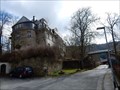 view gallery view gallerySE25.4 km |  Schloss Breidenstein Schloss Breidenstein
in Castles The Breidenstein Castle was built in 1712-1714 near the remains of a medieval castle. It is owned by the family von Breidenbach zu Breidenstein posted by: Eibacher Kuckuck location: Hessen, Germany date approved: 04/02/2016 last visited: 09/09/2016 |
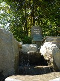
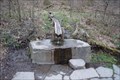
 view gallery view galleryS25.4 km |  Heilige Ilsequelle - Heiligenborn, NRW, Germany Heilige Ilsequelle - Heiligenborn, NRW, Germany
in Holy Wells Als heilige Ilse-Quelle war diese Quelle bereits im Mittelalter bekannt, ihrem Wasser wurden heilsame Kräfte zugeschrieben. | This holy well was already known in the Middle Ages. Healing powers were attributed to its water. posted by: Eibacher Kuckuck location: Nordrhein-Westfalen, Germany date approved: 10/20/2014 last visited: 11/15/2021 |
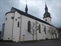 view gallery view galleryN25.7 km |  St. Walburga, Meschede, Deutschland St. Walburga, Meschede, Deutschland
in Roman Catholic Churches St. Walburga is an old roman-catholic church in the centre of Meschede posted by: Becktracker location: Nordrhein-Westfalen, Germany date approved: 02/19/2020 last visited: 12/11/2021 |
|