 view gallery view gallery SW1.8 km SW1.8 km
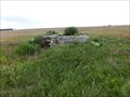
|   13°18'41,22"E 50°31'42,77"N, Bezrucovo údolí, Czechia 13°18'41,22"E 50°31'42,77"N, Bezrucovo údolí, Czechia
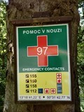
in Permanent Geographic Coordinates Tabulka "Pomoc v nouzi" 97 / Table "Emergency contacts" 97 posted by:  ashberry ashberry location: Ústecký kraj, Czechia date approved: 07/29/2020 last visited: never |
 view gallery view gallery S2.9 km S2.9 km
|  600 m - KAMENICKA (PREHR.), Czechia 600 m - KAMENICKA (PREHR.), Czechia
in Elevation Signs CZ/ Výška uvedená na rozcestníku "600 m - KAMENICKA (PREHR.)" EN/ Elevation Sign on crossroads "600 m - KAMENICKA (PREHR.)" posted by: ashberry location: Ústecký kraj, Czechia date approved: 07/30/2020 last visited: never |
 view gallery view gallery W3.1 km W3.1 km
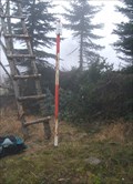
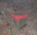
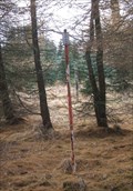
|  TB 0509-1 Jelenní vrch TB 0509-1 Jelenní vrch
in Czech Geodetic Points TB na jiznim uboci Jeleniho vrchu, 859m n.m. posted by: haggaeus location: Ústecký kraj, Czechia date approved: 11/02/2010 last visited: never |
 view gallery view gallery E3.5 km E3.5 km
| TB 0504-4 Jahodník in Czech Geodetic Points TB na vrcholu Mezihorskeho Vrchu, 916m n.m. posted by: haggaeus location: Ústecký kraj, Czechia date approved: 11/02/2010 last visited: never |
 view gallery view gallery N3.7 km N3.7 km
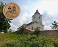
|  No. 2038, Kalek - Krusne Hory - Kostel svatého Václava, Czech Republic No. 2038, Kalek - Krusne Hory - Kostel svatého Václava, Czech Republic
in Tourist Stamps Photos Kalek - Krusne Hory - Church of St. Wenceslas posted by: ToRo61 location: Ústecký kraj, Czechia date approved: 07/15/2017 last visited: never |
 view gallery view galleryW4.2 km | TB 0509-7 Ve ctyrce in Czech Geodetic Points TB na zalesnenem kopci nad Bezrucovym udolim. posted by: haggaeus location: Ústecký kraj, Czechia date approved: 11/18/2009 last visited: never |
 view gallery view gallery NW4.3 km NW4.3 km
|  Altes Zollhaus Natzschung - Kriegwaldweg 49, Rübenau, Sachsen, Germany Altes Zollhaus Natzschung - Kriegwaldweg 49, Rübenau, Sachsen, Germany
in Bygone Toll Houses Torso of the old customs house (Altes Zollhaus Natzschung)on the Czech-Saxon border, at the bridge over the Natzschung Fluss. There was practically only a boat wall left. posted by: ashberry location: Sachsen, Germany date approved: 08/04/2021 last visited: never |
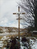 view gallery view galleryNW4.3 km |  Christian Cross - Altes Zollhaus, Rübenau, Sachsen, Germany Christian Cross - Altes Zollhaus, Rübenau, Sachsen, Germany
in Christian Crosses Cross at the border with the Czech Republic posted by: ashberry location: Sachsen, Germany date approved: 12/16/2019 last visited: never |
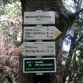 view gallery view gallerySW4.5 km |  Rozcestník turistických tras - Menhartice (rozv.), Czechia Rozcestník turistických tras - Menhartice (rozv.), Czechia
in Direction and Distance Arrows Rozcestník turistických tras Menhartice (rozv.) / Direction and Distance Arrows of tourist trails in Menhartice (rozv.) posted by: ashberry location: Ústecký kraj, Czechia date approved: 10/30/2019 last visited: never |
 view gallery view gallerySW4.5 km | 725m - MENHARTICE (ROZV.), Czechia in Elevation Signs CZ/ Výška uvedená na rozcestníku "725m - MENHARTICE (ROZV.)" EN/ Elevation Sign on crossroads "725m - MENHARTICE (ROZV.)" posted by: ashberry location: Ústecký kraj, Czechia date approved: 07/22/2019 last visited: never |
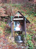 view gallery view gallerySW4.5 km |  Marian Spring in Bezrucovo udoli Marian Spring in Bezrucovo udoli
in Natural Springs A trailside spring with Virgin Mary picture. posted by: haggaeus location: Ústecký kraj, Czechia date approved: 11/18/2009 last visited: never |
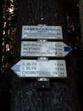
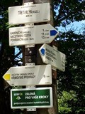 view gallery view galleryS4.8 km | Rozcestník turistických tras - Tretí mlýn (rozc.), Czechia in Direction and Distance Arrows Rozcestník turistických tras Tretí mlýn (rozc.) / Direction and Distance Arrows of tourist trails in Tretí mlýn (rozc.) posted by: ashberry location: Ústecký kraj, Czechia date approved: 10/31/2019 last visited: never |
 view gallery view galleryS4.8 km | 495m - TRETI MLÝN (ROZC.), Czechia in Elevation Signs CZ/ Výška uvedená na rozcestníku "495m - TRETI MLÝN (ROZC.)" EN/ Elevation Sign on crossroads "495m - TRETI MLÝN (ROZC.)" posted by: ashberry location: Ústecký kraj, Czechia date approved: 07/22/2019 last visited: never |
 view gallery view galleryS5 km |  The water dam of Krimov - Chomutov, Ustecky kraj/ Czech Republic The water dam of Krimov - Chomutov, Ustecky kraj/ Czech Republic
in Water Dams This is the water dam of Krimov posted by: kishin location: Ústecký kraj, Czechia date approved: 05/31/2014 last visited: never |
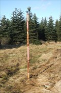
 view gallery view galleryNW5.3 km | TB 0508-6 U Vokraka in Czech Geodetic Points TB v Nacetinskych lesich. posted by: haggaeus location: Ústecký kraj, Czechia date approved: 11/02/2010 last visited: never |
 view gallery view gallerySW5.3 km |  Seidenspinner - Hora Svatého Šebestiána, Czech Republic Seidenspinner - Hora Svatého Šebestiána, Czech Republic
in Luftwaffe Radar Ruins Luftwaffe Radar Ruin Seidenspinner beside Hora Svatého Šebestiána village posted by: ToRo61 location: Ústecký kraj, Czechia date approved: 12/11/2017 last visited: never |
 view gallery view gallerySW6.1 km |  Transformátor CV 0866, Krimov, Czechia Transformátor CV 0866, Krimov, Czechia
in Historic Transformer Sub-Stations Buildings Distribucní zdená transformátorová stanice v Krimove, okr. Chomutov / Distribution brick transformer station in the Krimov village, Chomutov district posted by: ashberry location: Ústecký kraj, Czechia date approved: 08/19/2021 last visited: never |
 view gallery view gallerySW6.3 km | 705 m STRÁŽ (HÁJ.) - Krimov, Czechia in Elevation Signs Elevation Sign on crossroads "705 m STRÁŽ (HÁJ.)" posted by: ashberry location: Ústecký kraj, Czechia date approved: 08/19/2021 last visited: never |
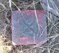
 view gallery view gallerySW6.3 km | BTP 3096.01 Hora Svatého Šebestiána in Czech Geodetic Points Tíhový bod 3096.01 Hora Svatého Šebestiána. Bod leží na severovýchodní strane námestí, v travnatém okraji parku. Bod je stabilizován betonovou deskou s hrebovou nivelacní znackou uprostred. posted by: ashberry location: Ústecký kraj, Czechia date approved: 08/14/2019 last visited: never |
 view gallery view galleryW6.3 km | TB 0508-5 V jednadvacítce in Czech Geodetic Points TB v modrinovem lese na vrcholu kopce, 840 m n.m. posted by: haggaeus location: Ústecký kraj, Czechia date approved: 11/18/2009 last visited: never |
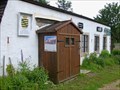
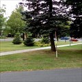
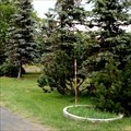
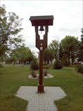 view gallery view gallerySW6.3 km |  Belfry in Hora Svatého Šebestiána / Zvonicka v Hore Svatého Šebestiána, Czechia Belfry in Hora Svatého Šebestiána / Zvonicka v Hore Svatého Šebestiána, Czechia
in Bell Towers Malá drevená zvonicka na námestí v Hore Svatého Šebestiána / Small wooden bell tower on the square in SHora svatého Šebestiána posted by: ashberry location: Ústecký kraj, Czechia date approved: 08/03/2019 last visited: never |
 view gallery view gallerySW6.3 km |  Payphone / Telefonni automat - Hora Svateho Sebestiana, Czech Republic Payphone / Telefonni automat - Hora Svateho Sebestiana, Czech Republic
in Payphones Classical Telefonica 02 Czech payphone. posted by: ToRo61 location: Ústecký kraj, Czechia date approved: 12/16/2017 last visited: never |
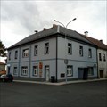 view gallery view gallerySW6.3 km |  Ceská pošta - 431 82 - Hora Svatého Šebestiána, Czechia Ceská pošta - 431 82 - Hora Svatého Šebestiána, Czechia
in European Post Offices Local post office in Hora Svatého Šebestiána 60. posted by: ashberry location: Ústecký kraj, Czechia date approved: 08/02/2019 last visited: never |
 view gallery view gallerySW6.3 km | TB 0509-10.1 Hora Sv.Šebestiána,kst. in Czech Geodetic Points Trigonometrický bod TB 0509-10.1 Hora Sv.Šebestiána,kst. Bod je námestí v Hore Svatého Šebestiána. Centrum prevedeno na ZB1 (kostel byl zboren). posted by: ashberry location: Ústecký kraj, Czechia date approved: 08/14/2019 last visited: never |
 view gallery view galleryE6.3 km | Bolebor - 431 21, Bolebor, Czech Republic in European Post Offices Local post office in Bolebor 57 posted by: ToRo61 location: Ústecký kraj, Czechia date approved: 07/16/2017 last visited: never |
|