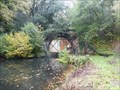
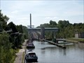
 view gallery view gallery NE0.6 km NE0.6 km
|   North West Entrance - Tunnel van Godarville - Charleroi-Brussel, channel - Belgium North West Entrance - Tunnel van Godarville - Charleroi-Brussel, channel - Belgium
in Canal Tunnels NW entrance of the 1050 meters long, (abandoned) Tunnel of Godarville posted by:  Axel-F Axel-F location: Hainaut, Belgium date approved: 10/26/2019 last visited: 03/16/2020 |
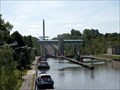
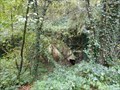 view gallery view gallery E1.4 km E1.4 km
| South East entrance - Tunnel van Godarville - Charleroi-Brussel, channel - Belgium in Canal Tunnels SE entrance of the 1050 meters long, (abandoned) Tunnel of Godarville posted by: Axel-F location: Hainaut, Belgium date approved: 10/28/2019 last visited: 10/28/2019 |
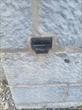 view gallery view gallery W2.9 km W2.9 km
|  NGI Point Altimétrique Kot4 - Manage - Belgique NGI Point Altimétrique Kot4 - Manage - Belgique
in Belgium Benchmarks Route Nivelles - Manage, église saintes Catherine et Philomène, Repère en fonte. posted by: PaulLassiter location: Hainaut, Belgium date approved: 05/10/2023 last visited: never |
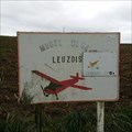 view gallery view galleryNE4.7 km |  Model Club Leuzois - Obaix, Belgium Model Club Leuzois - Obaix, Belgium
in Model Aircraft Fields Basis grass field of Model Club Leuzois. posted by: Axel-F location: Hainaut, Belgium date approved: 10/26/2019 last visited: 10/29/2019 |
 view gallery view gallery N6.1 km N6.1 km
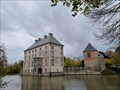
|  Château fort de Feluy - Feluy - Belgique Château fort de Feluy - Feluy - Belgique
in Castles [FR] Château fort du XIVème siècle, classé monument historique. [EN] 14th century castle, classified as a historical monument. posted by: PaulLassiter location: Brabant wallon, Belgium date approved: 11/29/2021 last visited: never |
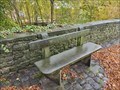 view gallery view galleryN6.1 km |  José Nicaise - Feluy - Belgique José Nicaise - Feluy - Belgique
in Dedicated Benches [FR] Banc public en pierre calcaire dédié à José Nicaise situé devant les douves du château de Feluy. [EN] Limestone public bench dedicated to José Nicaise located in front of the moat of Feluy castle. posted by: PaulLassiter location: Brabant wallon, Belgium date approved: 09/22/2023 last visited: never |
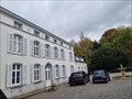 view gallery view galleryN6.1 km | Château Trichon - Feluy - Belgique in Castles [FR] Demeure du dernier Bailli de Feluy construit au XVIIIe siècle. [EN] Residence of the last Bailiff of Feluy built in the 18th century. posted by: PaulLassiter location: Brabant wallon, Belgium date approved: 12/01/2021 last visited: never |
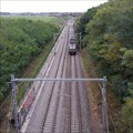 view gallery view galleryE6.8 km |  Bridge - Point-a Celles, Belgium Bridge - Point-a Celles, Belgium
in Active Rail Locations 2 site view point on bridge near Point-a Celles. posted by: Axel-F location: Hainaut, Belgium date approved: 10/27/2019 last visited: 10/05/2019 |
 view gallery view gallery SW6.9 km SW6.9 km
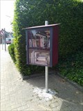
|  Boîte à livres à Morlanwelz, Belgique Boîte à livres à Morlanwelz, Belgique
in Free Community Book Exchanges Fr - Morlanwelz est une commune francophone de Belgique située en Région wallonne dans la province de Hainaut.
En - Morlanwelz is a French speaking commune in Belgium located in the Walloon Region in the province of Hainaut. posted by: geotrouvtou59 location: Hainaut, Belgium date approved: 08/06/2019 last visited: 08/08/2019 |
 view gallery view galleryW7.4 km |  La Porte de Garde du "Blanc Pain" La Porte de Garde du "Blanc Pain"
in Waterway Locks, Planes and Lifts The "Porte de Garde du Blanc Pain" is a security gate on the "Canal du Centre" posted by: brixmed location: Belgium date approved: 07/27/2006 last visited: never |
 view gallery view galleryW7.6 km |  La Cam des Loups / Wolf's cam La Cam des Loups / Wolf's cam
in Web Cameras Webcam du site Météo amateur de La Louvière posted by: Efreet location: Hainaut, Belgium date approved: 04/30/2012 last visited: never |
 view gallery view gallery S9.5 km S9.5 km
|  Le cimetière militaire Français de Carnières-Collarmont, Begique Le cimetière militaire Français de Carnières-Collarmont, Begique
in Veteran Cemeteries Fr - Le cimetière de Carnières-Collarmont, et ses 248 tombes françaises, sont là pour rappeler les tragiques combats
En - Carnières-Collarmont Cemetery, and its 248 French graves, are here to remember the tragic battles posted by: geotrouvtou59 location: Hainaut, Belgium date approved: 08/06/2019 last visited: 08/08/2019 |
 view gallery view galleryS9.5 km |  Le cimetière militaire Français de Carnières-Collarmont, Belgique Le cimetière militaire Français de Carnières-Collarmont, Belgique
in World War I Sites Fr - Le cimetière de Carnières-Collarmont, et ses 248 tombes françaises, sont là pour rappeler les tragiques combats
En - Carnières-Collarmont Cemetery, and its 248 French graves, are here to remember the tragic battles posted by: geotrouvtou59 location: Hainaut, Belgium date approved: 12/26/2022 last visited: 01/07/2023 |
 view gallery view galleryS9.5 km |  Le cimetière militaire Français de Carnières-Collarmont, Begique Le cimetière militaire Français de Carnières-Collarmont, Begique
in Satellite Imagery Oddities En - Carnières-Collarmont Cemetery, and its 248 French graves, are here to remember the tragic battles
Fr - Le cimetière de Carnières-Collarmont, et ses 248 tombes françaises, sont là pour rappeler les tragiques combats posted by: geotrouvtou59 location: Hainaut, Belgium date approved: 04/26/2020 last visited: 04/26/2020 |
 view gallery view galleryW9.8 km | Le Pont Canal du Sart in Waterway Locks, Planes and Lifts The "Pont Canal du Sart" is a 498 meters long bridge, over the "Thiriau du Sart" valley, allowing ships up to 1350 tons to cross over two speedways (N 55 and N 535). posted by: brixmed location: Belgium date approved: 07/27/2006 last visited: 12/21/2008 |
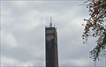 view gallery view gallery NW10 km NW10 km
| NGI Meetpunt 39F50C1, Tour du plan incliné, Ronquieres in Belgium Benchmarks Tour du plan incliné de Ronquieres posted by:  TeamYakara TeamYakara location: Brabant wallon, Belgium date approved: 09/09/2023 last visited: never |
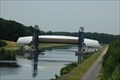
 view gallery view galleryNW10 km |  Plan incliné de Ronquières - Ronquières, Belgique Plan incliné de Ronquières - Ronquières, Belgique
in Wikipedia Entries FR - Le plan incliné de Ronquières est un ascenseur à bateaux près de Ronquières (Braine-le-Comte).
EN - The inclined plane of Ronquières is a boat lift near Ronquières. posted by: geotrouvtou59 location: Hainaut, Belgium date approved: 04/17/2020 last visited: 08/10/2017 |
 view gallery view galleryNW10 km | Plan incliné de Ronquières - Ronquières, Belgique in Satellite Imagery Oddities FR - Le plan incliné de Ronquières est un ascenseur à bateaux près de Ronquières (Braine-le-Comte).
EN - The inclined plane of Ronquières is a boat lift near Ronquières. posted by: geotrouvtou59 location: Hainaut, Belgium date approved: 04/23/2020 last visited: 04/23/2020 |
 view gallery view galleryNW10 km | Plan incliné de Ronquières - Ronquières, Belgique in Waterway Locks, Planes and Lifts FR - Le plan incliné de Ronquières est un ascenseur à bateaux près de Ronquières (Braine-le-Comte).
EN - The inclined plane of Ronquières is a boat lift near Ronquières (Braine-le-Comte). posted by: geotrouvtou59 location: Hainaut, Belgium date approved: 04/17/2020 last visited: 04/18/2016 |
 view gallery view galleryN11.3 km | NGI Meetpunt Kn15, Centrale électrique du plan incliné. in Belgium Benchmarks Centrale électrique du plan incliné, Ronquieres posted by: TeamYakara location: Brabant wallon, Belgium date approved: 08/31/2023 last visited: never |
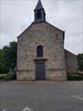 view gallery view gallery SE11.6 km SE11.6 km
|  Chapelle Notre-Dame de Heigne - Charleroi - Belgique Chapelle Notre-Dame de Heigne - Charleroi - Belgique
in Roman Catholic Churches Romanesque and Gothic chapel of the 12th century, important place of pilgrimage at the time dedicated to the Virgin of Heigne, sometimes called the 'Virgin with pebbles' posted by: PaulLassiter location: Hainaut, Belgium date approved: 08/15/2018 last visited: never |
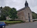 view gallery view gallerySE11.7 km |  Chapelle Notre-Dame de Heigne - Charleroi - Belgique Chapelle Notre-Dame de Heigne - Charleroi - Belgique
in Belgium Monument Registers Romanesque and Gothic chapel of the 12th century, important place of pilgrimage at the time dedicated to the Virgin of Heigne, sometimes called the 'Virgin with pebbles'. posted by: PaulLassiter location: Hainaut, Belgium date approved: 08/15/2018 last visited: never |
 view gallery view gallerySE11.7 km | Chapelle Notre-Dame de Heigne - Charleroi - Belgique in Wikipedia Entries Romanesque and Gothic chapel of the 12th century, important place of pilgrimage at the time dedicated to the Virgin of Heigne, sometimes called the 'Virgin with pebbles'. posted by: PaulLassiter location: Hainaut, Belgium date approved: 08/15/2018 last visited: never |
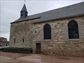 view gallery view gallerySE11.7 km |  Chapelle Notre-Dame de Heigne - Charleroi - Belgique Chapelle Notre-Dame de Heigne - Charleroi - Belgique
in Romanesque Architecture Romanesque and Gothic chapel of the 12th century, important place of pilgrimage at the time dedicated to the Virgin of Heigne, sometimes called the 'Virgin with pebbles' posted by: PaulLassiter location: Hainaut, Belgium date approved: 09/09/2018 last visited: never |
 view gallery view gallerySE11.7 km | Chapelle Notre-Dame de Heigne - Charleroi - Belgique in This Old Church Romanesque and Gothic chapel of the 12th century, important place of pilgrimage at the time dedicated to the Virgin of Heigne, sometimes called the 'Virgin with pebbles'. posted by: PaulLassiter location: Hainaut, Belgium date approved: 09/17/2018 last visited: never |
|