 view gallery view gallery NW1 km NW1 km
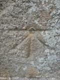
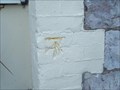
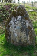
|   CUT BENCH MARK, ST MARY'S CHURCH, PLYMPTON CUT BENCH MARK, ST MARY'S CHURCH, PLYMPTON
in U.K. and Ireland Trigpoints A cut bench mark on a Plymouth church. posted by:  plymplodder plymplodder location: United Kingdom date approved: 06/26/2008 last visited: 06/26/2008 |
 view gallery view gallery W2.6 km W2.6 km
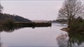
|  DESTINATION River Plym Plymouth Devon UK DESTINATION River Plym Plymouth Devon UK
in River Origins, Destinations and Confluences The river Plym enters the Plymouth Sound posted by:  MoreOutdoor MoreOutdoor location: South West England, United Kingdom date approved: 06/27/2019 last visited: 06/27/2019 |
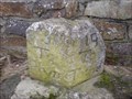
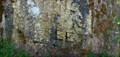
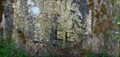
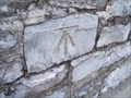 view gallery view galleryW2.6 km | CUT BENCH MARK, PLYMOUTH ROAD, PLYMOUTH in U.K. and Ireland Trigpoints A cut benchmark in Plymouth. posted by: plymplodder location: United Kingdom date approved: 04/05/2008 last visited: 04/21/2010 |
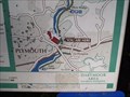 view gallery view galleryNW2.7 km |  Plym Valley Cycle Way, Coy Pool, Plymouth, Devon UK. Plym Valley Cycle Way, Coy Pool, Plymouth, Devon UK.
in 'You Are Here' Maps A map in Plymouth, Devon. posted by: Brentorboxer location: South West England, United Kingdom date approved: 11/24/2010 last visited: 12/03/2010 |
 view gallery view gallery SW2.9 km SW2.9 km
| CUT BENCH MARK, ELBURTON HOTEL, PLYMOUTH in U.K. and Ireland Trigpoints A cut bench mark on a Plymouth pub. posted by: plymplodder location: United Kingdom date approved: 05/21/2008 last visited: 05/21/2008 |
 view gallery view gallerySW2.9 km |  Guidestone on A379 Billacombe Road Guidestone on A379 Billacombe Road
in Milestones A guide stone in Plymouth. posted by: plymplodder location: United Kingdom date approved: 01/04/2009 last visited: 01/04/2009 |
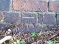 view gallery view gallerySW3.1 km | CUT BENCH MARK, ELBURTON ROAD, PLYMOUTH in U.K. and Ireland Trigpoints A cut bench mark in Plymouth. posted by: plymplodder location: United Kingdom date approved: 05/20/2008 last visited: 05/20/2008 |
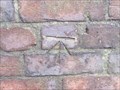 view gallery view gallerySW3.1 km | CUT BENCH MARK, COLESDOWN HILL in U.K. and Ireland Trigpoints A cut bench mark in Plymouth. posted by: plymplodder location: United Kingdom date approved: 06/05/2008 last visited: 06/05/2008 |
 view gallery view galleryNW3.5 km |  Dragon fly Dragon fly
in Insect Sculptures Walking up from the Marsh Mills car park alongside of the rail line I came across this dragon fly Sculpture posted by: MoreOutdoor location: South West England, United Kingdom date approved: 04/30/2019 last visited: 03/31/2017 |
 view gallery view gallery NE3.5 km NE3.5 km
|  582 feet - Hemerdon Ball Height Stone Plymouth Devon UK 582 feet - Hemerdon Ball Height Stone Plymouth Devon UK
in Elevation Signs A very old stone, with markings above sea level, which read.
"HHT 1862 THE SEA LEVEL OF THIS PLACE IS 582 FEET" with a bench mark under. posted by: MoreOutdoor location: South West England, United Kingdom date approved: 05/29/2019 last visited: 05/28/2019 |
 view gallery view galleryNE3.5 km |  Hemerdon Ball Height Stone Plymouth Devon UK Hemerdon Ball Height Stone Plymouth Devon UK
in UK Historical Markers An old stone, with markings, which read.
"HHT 1862 THE SEA LEVEL OF THIS PLACE IS 582 FEET" with a bench mark under. What is unusual about this stone is its location and the question why was the sea level height measured at this point? posted by: MoreOutdoor location: South West England, United Kingdom date approved: 05/30/2019 last visited: 05/29/2019 |
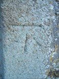
 view gallery view galleryNE3.5 km | Cut Benchmark Hemerdon Ball Plympton Devon UK in U.K. and Ireland Trigpoints A cut Benchmark set within a large stone and markings indicating height above sea level. posted by: MoreOutdoor location: South West England, United Kingdom date approved: 06/03/2019 last visited: 05/28/2019 |
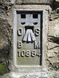
 view gallery view galleryNE3.5 km |  Survey Stone Hemerdon Ball Plympton Devon UK Survey Stone Hemerdon Ball Plympton Devon UK
in European Historic Survey Stones, Monuments and Benchmarks Above the city of Plymouth UK is a stone which has been inscribed with HHT 1892 THE SEA LEVEL OF THIS PLACE IS 582 FEET with a Bench Mark underneath. posted by: MoreOutdoor location: South West England, United Kingdom date approved: 05/30/2019 last visited: 05/28/2019 |
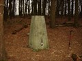 view gallery view galleryNE3.5 km | Hemerdon Ball TP in U.K. and Ireland Trigpoints Trig Pillar on Hemerdon Ball, a hill north-west of Sparkwell, Devon posted by: Lord Darcy location: United Kingdom date approved: 01/29/2008 last visited: 01/29/2008 |
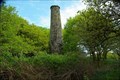 view gallery view galleryNE3.5 km |  Lone Chimney Hemerdon, Plympton Devon UK Lone Chimney Hemerdon, Plympton Devon UK
in Lonely Chimneys Found this lone chimney hidden within the woods. posted by: MoreOutdoor location: South West England, United Kingdom date approved: 05/29/2019 last visited: 05/29/2019 |
 view gallery view galleryNW3.5 km | FLUSH BRACKET, PLYM BRIDGE in U.K. and Ireland Trigpoints A flush bracket on a former railway bridge. posted by: plymplodder location: United Kingdom date approved: 04/01/2008 last visited: 09/13/2008 |
 view gallery view gallery S3.5 km S3.5 km
| CUT BENCH MARK, ST MARYS CHURCH, BRIXTON in U.K. and Ireland Trigpoints A cut bench mark on a South Devon church. posted by: plymplodder location: United Kingdom date approved: 04/05/2008 last visited: 04/04/2008 |
 view gallery view galleryNW3.5 km |  Plymbridge railway bridge on the Plym Valley Cycle Route, Devon Plymbridge railway bridge on the Plym Valley Cycle Route, Devon
in Arch Bridges An old arched railway bridge now used as part of the Plym Valley Cycle Route posted by: Sir Lose-a-lot location: United Kingdom date approved: 09/14/2008 last visited: 09/14/2008 |
 view gallery view galleryNW3.5 km |  Plymbridge railway bridge on the Plym Valley Cycle Route, Devon Plymbridge railway bridge on the Plym Valley Cycle Route, Devon
in Stone Bridges An old stone railway bridge now used as part of the Plym Valley Cycle Route posted by: Sir Lose-a-lot location: United Kingdom date approved: 09/15/2008 last visited: 09/14/2008 |
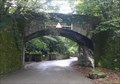 view gallery view galleryNW3.5 km |  Plymbridge railway bridge on the Plym Valley Cycle Route, Devon , UK Plymbridge railway bridge on the Plym Valley Cycle Route, Devon , UK
in Railroad Bridges An old railway bridge now used as part of the Plym Valley Cycle Route posted by: Sir Lose-a-lot location: United Kingdom date approved: 09/15/2008 last visited: 09/14/2008 |
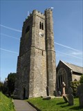 view gallery view galleryS3.7 km |  St Mary's Parish Church, Brixton, South Devon St Mary's Parish Church, Brixton, South Devon
in This Old Church A pleasant country church in the South Devon village of Brixton. posted by: Sir Lose-a-lot location: United Kingdom date approved: 04/07/2008 last visited: 04/04/2008 |
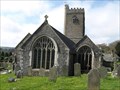 view gallery view galleryS3.7 km |  St Mary's Parish Church, Brixton, South Devon St Mary's Parish Church, Brixton, South Devon
in Medieval Churches A pleasant mediaeval church in the South Devon village of Brixton. posted by: Sir Lose-a-lot location: United Kingdom date approved: 04/14/2008 last visited: 04/04/2008 |
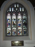 view gallery view galleryS3.7 km |  Stained glass window in St Mary's Church, Brixton, Devon Stained glass window in St Mary's Church, Brixton, Devon
in Stained Glass Windows St Mary's is a lovely church with some very nice stained glass. posted by: Sir Lose-a-lot location: United Kingdom date approved: 04/11/2008 last visited: 04/04/2008 |
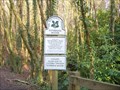 view gallery view galleryNW3.7 km |  Plymbridge Woods, near Plymouth Plymbridge Woods, near Plymouth
in National Trust U.K. Plymbridge Woods, near Plymouth, Devon, on and around the Plym Valley Cycle Trail. One of many entrances. posted by: Lord Darcy location: United Kingdom date approved: 02/12/2008 last visited: 09/13/2008 |
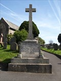 view gallery view galleryS3.7 km |  War Memorial at Brixton, South Devon War Memorial at Brixton, South Devon
in World War I Memorials and Monuments A First World War Memorial sited in the churchyard of St Mary's church in Brixton. posted by: Sir Lose-a-lot location: United Kingdom date approved: 04/13/2008 last visited: 04/04/2008 |
|