 view gallery view gallery N3.9 km N3.9 km
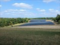
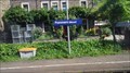
|   Solarpark Kaifenheim - Kaifenheim - Germany, Rhineland-Palatinate Solarpark Kaifenheim - Kaifenheim - Germany, Rhineland-Palatinate
in Solar Power A solar plant on a former debris dump. posted by:  ColleIsarco ColleIsarco location: Rheinland-Pfalz, Germany date approved: 03/13/2023 last visited: never |
 view gallery view gallery S4.2 km S4.2 km
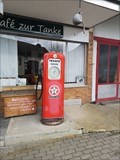
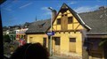
|  Texaco Station Kail - Germany - Rhineland-Palatinate Texaco Station Kail - Germany - Rhineland-Palatinate
in Vintage Gasoline Pumps An old gasoline pump of the long gone (in Germany) brand Texaco. posted by: ColleIsarco location: Rheinland-Pfalz, Germany date approved: 04/15/2022 last visited: never |
 view gallery view gallery NE4.3 km NE4.3 km
|  Bericht "Burg Pyrmont: Hier werden Märchen wahr" - Roes, RP, Germany Bericht "Burg Pyrmont: Hier werden Märchen wahr" - Roes, RP, Germany
in News Article Locations Bericht "Burg Pyrmont: Hier werden Märchen wahr" in der Rhein-Zeitung. posted by: kaschper69 location: Rheinland-Pfalz, Germany date approved: 03/29/2018 last visited: 03/29/2018 |
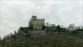
 view gallery view galleryNE4.3 km |  Burg Pyrmont - Pillig, Rhineland-Palatinate, Germany Burg Pyrmont - Pillig, Rhineland-Palatinate, Germany
in Wikipedia Entries The Pyrmont Castle (Burg Pyrmont) is west of Münstermaifeld near Roes and Pillig on a slate rock above the waterfall of Elzbachs in the southern Eifel. It belongs to the denunciation of the local church Roes (district Cochem-Zell). posted by: kaschper69 location: Rheinland-Pfalz, Germany date approved: 08/01/2016 last visited: 07/31/2016 |
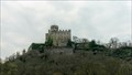 view gallery view galleryNE4.3 km |  Castle Pyrmont - Pillig, Rhineland-Palatinate, Germany Castle Pyrmont - Pillig, Rhineland-Palatinate, Germany
in Castles The Pyrmont Castle is west of Münstermaifeld near Roes and Pillig on a slate rock above the waterfall of Elzbachs in the southern Eifel. It belongs to the denunciation of the local church Roes (district Cochem-Zell). posted by: kaschper69 location: Rheinland-Pfalz, Germany date approved: 08/01/2016 last visited: 08/01/2016 |
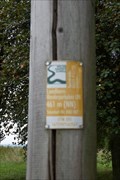
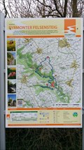 view gallery view galleryNE4.5 km |  Traumpfad - Pyrmonter Felsensteig - Roes, Rhineland-Palatinate, Germany Traumpfad - Pyrmonter Felsensteig - Roes, Rhineland-Palatinate, Germany
in Hiking and walking trailheads Traumpfad "Pyrmonter Felsensteig" in Roes. posted by: kaschper69 location: Rheinland-Pfalz, Germany date approved: 03/06/2017 last visited: 03/06/2017 |
 view gallery view galleryNE4.5 km |  Elzbach 3 - Pillig - RLP - Germany Elzbach 3 - Pillig - RLP - Germany
in Bridgeless Water Crossings Furt am Elzbach für land- und forstwirtschaftliche Fahrzeuge. posted by:  CADS11 CADS11 location: Rheinland-Pfalz, Germany date approved: 03/13/2018 last visited: 03/13/2018 |
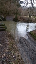 view gallery view galleryNE4.5 km | Elzbach 2 - Pillig - RLP - Germany in Bridgeless Water Crossings Furt am Elzbach für land- und forstwirtschaftliche Fahrzeuge. posted by: CADS11 location: Rheinland-Pfalz, Germany date approved: 03/13/2018 last visited: 03/13/2018 |
 view gallery view gallery E4.8 km E4.8 km
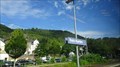
|  Theaterdorf Möntenich - Germany - Rhineland / Palatinate Theaterdorf Möntenich - Germany - Rhineland / Palatinate
in Welcome Signs The actors of the local theater let you welcome. posted by: ColleIsarco location: Rheinland-Pfalz, Germany date approved: 09/14/2021 last visited: never |
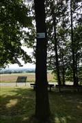
 view gallery view galleryNE5.6 km |  341 m ü. NN Viewpoint Kollig, Rhineland-Palatinate, Germany 341 m ü. NN Viewpoint Kollig, Rhineland-Palatinate, Germany
in Elevation Signs [DE] An diesem Aussichtspunkt überhalb von Kollig befindet sich dieses Elevation Sign. [EN] This Elevation sign is located at a viewpoint above Kollig. posted by: kaschper69 location: Rheinland-Pfalz, Germany date approved: 03/18/2016 last visited: 03/18/2016 |
 view gallery view gallery SE6.3 km SE6.3 km
|  Pommern - Germany Pommern - Germany
in Train Stations/Depots Pommen is a train station in the south of Germany posted by: superstein location: Rheinland-Pfalz, Germany date approved: 12/14/2021 last visited: 07/07/2022 |
 view gallery view galleryS6.4 km | Klotten - Germany in Train Stations/Depots Klotten is a bahnhof on the Mosel track line posted by: superstein location: Rheinland-Pfalz, Germany date approved: 12/06/2021 last visited: never |
 view gallery view gallerySE6.6 km | Treis Karden - Germany in Train Stations/Depots The train station in Treis-Karden is on the Moselle route. Here the RE (regional express) and RB (regional train) run between Trier and Koblenz. posted by: superstein location: Rheinland-Pfalz, Germany date approved: 12/18/2021 last visited: 07/07/2022 |
 view gallery view gallery W6.6 km W6.6 km
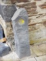
|  Way Marker - Balduinstraße/Brunnenstraße - Kaisersesch, Rhineland-Palatinate, Germany Way Marker - Balduinstraße/Brunnenstraße - Kaisersesch, Rhineland-Palatinate, Germany
in Way of St. James [DE] Way marker in Kaisersesch.
[EN] Way marker in Kaisersesch. posted by: kaschper69 location: Rheinland-Pfalz, Germany date approved: 10/06/2016 last visited: 10/01/2016 |
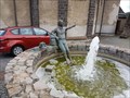
 view gallery view galleryW6.6 km |  Pilgerbrunnen - Kaisersesch, Rhineland-Palatinate, Germany Pilgerbrunnen - Kaisersesch, Rhineland-Palatinate, Germany
in Fountains T posted by: kaschper69 location: Rheinland-Pfalz, Germany date approved: 10/06/2016 last visited: 10/02/2016 |
 view gallery view galleryW6.6 km | Way Marker - Pilgerbrunnen - Kaisersesch, Rhineland-Palatinate, Germany in Way of St. James [DE] Way marker in Kaisersesch.
[EN] Way marker in Kaisersesch. posted by: kaschper69 location: Rheinland-Pfalz, Germany date approved: 10/06/2016 last visited: 10/02/2016 |
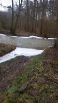 view gallery view galleryE6.8 km | Elzbach 1 - Keldung - RLP - Germany in Bridgeless Water Crossings Furt am Elzbach für land- und forstwirtschaftliche Fahrzeuge. posted by: CADS11 location: Rheinland-Pfalz, Germany date approved: 03/13/2018 last visited: 03/17/2018 |
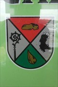 view gallery view galleryW6.8 km |  Coat of Arms - Landkern, Germany Coat of Arms - Landkern, Germany
in Coats of Arms Coat of Arms inside Info Punkt Landkern located along the L98 between Kaiseresch and Landkern, Germany. posted by: dreamhummie location: Rheinland-Pfalz, Germany date approved: 12/29/2021 last visited: never |
 view gallery view galleryW6.8 km | 461m - Landkern, Germany in Elevation Signs Elevation Sign, 461m, near the Info Punkt Landkern located along the L98 between Kaiseresch and Landkern, Germany. posted by: dreamhummie location: Rheinland-Pfalz, Germany date approved: 05/23/2022 last visited: never |
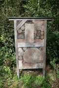 view gallery view galleryW6.8 km |  Insektenhotel - Landkern, Germany Insektenhotel - Landkern, Germany
in Insect Hotels Insektenhotel nearby Schutzhütte Landkern in the outskirts od the town Landkern, Germany. posted by: dreamhummie location: Rheinland-Pfalz, Germany date approved: 12/28/2021 last visited: never |
 view gallery view galleryW6.8 km |  Matthias Frings Eiche - Landkern, Germany Matthias Frings Eiche - Landkern, Germany
in Dedicated Trees Oak dedicated to Matthias Frings in front of the Schutzhütte in Landkern, Germany. posted by: dreamhummie location: Rheinland-Pfalz, Germany date approved: 05/25/2023 last visited: never |
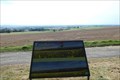 view gallery view galleryW6.8 km |  Landkern Mein Urlaubsziel - Landkern, Germany Landkern Mein Urlaubsziel - Landkern, Germany
in Orientation Tables Orientation Table on a hill, located in the outskirts of Landkern, Germany. posted by: dreamhummie location: Rheinland-Pfalz, Germany date approved: 12/27/2021 last visited: never |
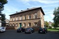 view gallery view gallerySE7.2 km |  Ehemalige Knabenschule - Treis-Karden, Deutschland Ehemalige Knabenschule - Treis-Karden, Deutschland
in Deutsche Denkmallisten - German Monument Registers Ehemalige Knabenschule Am Plenzer 1 in Treis-Karden, Deutschland posted by: dreamhummie location: Rheinland-Pfalz, Germany date approved: 09/29/2021 last visited: never |
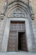 view gallery view gallerySE7.2 km |  Doorway - St. Johannes der Täufer - Treis-Karden, Germany Doorway - St. Johannes der Täufer - Treis-Karden, Germany
in Doorways of the World Doorway of the church named "St. Johannes der Täufer" located Am Plenzer 2 in Treis-Karden, Germany. posted by: dreamhummie location: Rheinland-Pfalz, Germany date approved: 10/02/2021 last visited: never |
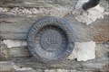 view gallery view gallerySE7.2 km |  Königlich Preußische Landesaufnahme - Pfarrkirche St. Johannes der Täufer - Treis-Karden, Germany Königlich Preußische Landesaufnahme - Pfarrkirche St. Johannes der Täufer - Treis-Karden, Germany
in German Benchmarks Height fixed point of the Royal Prussian Land Survey at the Pfarrkirche St. Johannes der Täufer Am Plenzer 2 in Treis-Karden, Germany. posted by: dreamhummie location: Rheinland-Pfalz, Germany date approved: 09/29/2021 last visited: never |
|