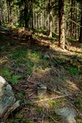
 view gallery view gallery S3.2 km S3.2 km
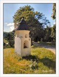
|   Wayside shride of Saint Onuphrius / Kapliczka sw.Onufrego - Pisary, Poland Wayside shride of Saint Onuphrius / Kapliczka sw.Onufrego - Pisary, Poland
in Wayside shrines Prismatic wayside shrine made of plastered bricks with a conical roof at the road in village Pisary near Miedzylesie at the borders with the Czech Republic posted by:  vraatja vraatja location: Dolnośląskie, Poland date approved: 07/28/2019 last visited: never |
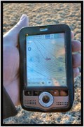
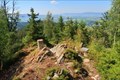
 view gallery view gallery E3.4 km E3.4 km
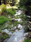
|  ORIGIN - Nysa Klodzka ORIGIN - Nysa Klodzka
in River Origins, Destinations and Confluences The origin of Nysa Klodzka. posted by:  Anneke Anneke location: Dolnośląskie, Poland date approved: 05/05/2009 last visited: 05/02/2009 |
 view gallery view gallery SE3.5 km SE3.5 km
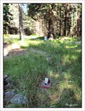
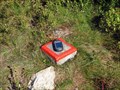
|  TB 2511-8 Jelení vrch, PL TB 2511-8 Jelení vrch, PL
in Czech Geodetic Points Trigonometrický bod ležící na okraji masívu Kralického Snežníku na území Polské Republiky posted by: vraatja location: Dolnośląskie, Poland date approved: 07/21/2011 last visited: never |
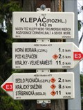
 view gallery view galleryE3.9 km | TB 2511-4 Klepác in Czech Geodetic Points Trigonometrický bod na vrcholu Klepác posted by: alicek location: Pardubický kraj, Czechia date approved: 09/28/2008 last visited: 12/27/2015 |
 view gallery view galleryE3.9 km |  No. 1879, Rozhledna Klepy, PL No. 1879, Rozhledna Klepy, PL
in Tourist Stamps Photos Klepy Look-Out posted by: ToRo61 location: Śląskie, Poland date approved: 12/12/2015 last visited: never |
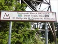 view gallery view galleryE3.9 km |  Trójmorski Wierch - Klepy, Poland Trójmorski Wierch - Klepy, Poland
in Geographical Centers Trójmorski Wierch - Europe watershed (a roof of Europe). posted by: ToRo61 location: Śląskie, Poland date approved: 12/16/2015 last visited: never |
 view gallery view galleryE3.9 km |  Elevation Sign - Klepy, Poland.1143m Elevation Sign - Klepy, Poland.1143m
in Elevation Signs Elevation Sign - Klepy, on the top of Klepy Mountain posted by: ToRo61 location: Śląskie, Poland date approved: 12/12/2015 last visited: never |
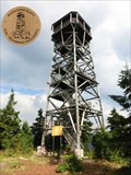
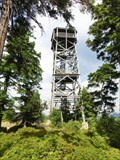 view gallery view galleryE3.9 km |  Klepac Look-Out - Klepy, Poland Klepac Look-Out - Klepy, Poland
in Look-Out Towers Klepac Look-Out posted by: ToRo61 location: Małopolskie, Poland date approved: 12/12/2015 last visited: never |
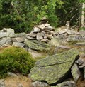 view gallery view galleryE3.9 km |  Cairn - Klepy, Poland Cairn - Klepy, Poland
in Cairns Cairn on the top of roof of Europe... posted by: ToRo61 location: Śląskie, Poland date approved: 12/28/2015 last visited: never |
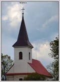
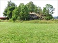
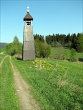 view gallery view gallerySE4.2 km |  Bell tower at Freudeberg / Zvonicka na Freudebergu Bell tower at Freudeberg / Zvonicka na Freudebergu
in Bell Towers An interesting bell tower close to the tourist trail. posted by: Dadan location: Pardubický kraj, Czechia date approved: 05/05/2009 last visited: 08/22/2010 |
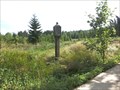
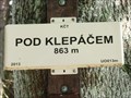 view gallery view galleryE4.2 km | Elevation Sign - Pod Klepacem, Czech Republic.863m in Elevation Signs Elevation Sign - Pod Klepacem posted by: ToRo61 location: Pardubický kraj, Czechia date approved: 12/12/2015 last visited: never |
 view gallery view gallerySE4.7 km | TB 2511-10 Vetronka, CZ in Czech Geodetic Points Trigonometrický bod na vrcholu Vetrného kopce v oblasti prírodního parku Kralický Snežník. posted by: vraatja location: Pardubický kraj, Czechia date approved: 08/22/2010 last visited: never |
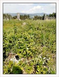
 view gallery view gallerySE5 km |  Palindrome - Horní Lipka (East Bohemia), Czech Republic Palindrome - Horní Lipka (East Bohemia), Czech Republic
in Coordinate Palindromes Coordinate palindrome on pastures located on the fringe of national nature preserve - Kralický Snežník mountain range. posted by: vraatja location: Pardubický kraj, Czechia date approved: 03/10/2011 last visited: never |
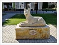 view gallery view gallery W5.1 km W5.1 km
|  Wolf of Miedzylesie / Wilk Miedzyleski - Miedzylesie, Poland Wolf of Miedzylesie / Wilk Miedzyleski - Miedzylesie, Poland
in Figurative Public Sculpture Marble statue of a wolf, a heraldic animal of the city Miedzylesie is located on the town' square (Rynek Miejski) since 2014. posted by: vraatja location: Dolnośląskie, Poland date approved: 11/26/2020 last visited: never |
 view gallery view gallerySE5.1 km | TB 2512-3 kostel, Horní Lipka, CZ in Czech Geodetic Points Trigometrický bod tvorený stredem makovice veže rímskokatolického filiálního kostela sv. Anny v Horní Lipce. posted by: vraatja location: Pardubický kraj, Czechia date approved: 05/24/2010 last visited: never |
 view gallery view galleryS5.3 km | TB 2512-2 Roudný, CZ in Czech Geodetic Points Trigonometrický bod na vrcholu kopce Roudný ležícího západním smerem nad Horní Lipkou na Kralicku. posted by: vraatja location: Pardubický kraj, Czechia date approved: 05/28/2018 last visited: never |
 view gallery view gallery NE6.3 km NE6.3 km
| TB 2511-2 U boudy in Czech Geodetic Points Trigonometrický bod v masivu Králického Snežníku posted by: alicek location: Pardubický kraj, Czechia date approved: 07/19/2015 last visited: never |
 view gallery view galleryE6.4 km | ZGS 16_n KRAL in Czech Geodetic Points Bod základní geodynamické síte c. 16 KRAL (Králíky) posted by: rsc_cz location: Pardubický kraj, Czechia date approved: 02/12/2021 last visited: never |
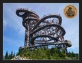 view gallery view galleryE6.6 km | No. 2255 - Stezka v oblacích - Dolní Morava, CZ in Tourist Stamps Photos The Sky Walk is a 55-m (180-ft)-high wooden walkway on top of a mountain at the top station of chair lift Snežník, at an altitude of 1116 meters above sea level./ Unikátní 55 metru vysoká rozhledna na úpatí hory Slamník v nadmorské výšce 1116 metru. posted by: vraatja location: Pardubický kraj, Czechia date approved: 07/12/2016 last visited: 09/22/2017 |
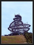 view gallery view galleryE6.6 km | Sky walk / Stezka v oblacích - Dolní Morava, Czech Republic in Look-Out Towers Unique, huge wooden structure at the top station of chair lift Snežník, at an altitude of 1116 meters above sea level. Its height is 55 meters and the summit can be easily reached along a wooden path even with strollers and wheelchairs. posted by: vraatja location: Pardubický kraj, Czechia date approved: 07/11/2016 last visited: 09/22/2017 |
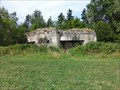
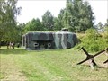 view gallery view gallerySE6.6 km |  Infantry blockhouse K-S 8 - Cerveny Potok, Czech Republic Infantry blockhouse K-S 8 - Cerveny Potok, Czech Republic
in Military Installations The infantry blockhouse K-S 8 (code name "U nádraží") is part of the extended system of fortifications built to defend the former Czechoslovakia during the second half of the 30s. posted by: ToRo61 location: Pardubický kraj, Czechia date approved: 12/18/2015 last visited: never |
 view gallery view galleryNE6.8 km | TB 2511-1 Maly Sneznik in Czech Geodetic Points Trigonometrický bod na Malém Snežníku posted by: alicek location: Pardubický kraj, Czechia date approved: 07/19/2015 last visited: never |
 view gallery view gallerySE6.9 km | Wayside shrine - Cerveny Potok, Czech Republic in Wayside shrines Wayside shrine - Cerveny Potok posted by: ToRo61 location: Pardubický kraj, Czechia date approved: 12/18/2015 last visited: never |
 view gallery view gallerySE6.9 km | Infantry blockhouse K-S 7 - Cerveny Potok, Czech Republic in Military Installations The infantry blockhouse K-S 7 (code name "U vesnice") is part of the extended system of fortifications built to defend the former Czechoslovakia during the second half of the 30s. posted by: ToRo61 location: Pardubický kraj, Czechia date approved: 12/18/2015 last visited: never |
 view gallery view gallerySE6.9 km | Infantry blockhouse K-S 6 - Cerveny Potok, Czech Republic in Military Installations The infantry blockhouse K-S 6 (code name "U kaplicky") is part of the extended system of fortifications built to defend the former Czechoslovakia during the second half of the 30s. posted by: ToRo61 location: Pardubický kraj, Czechia date approved: 12/18/2015 last visited: never |
|