 view gallery view gallery E1.9 km E1.9 km
|   TB 2511-8 Jelení vrch, PL TB 2511-8 Jelení vrch, PL
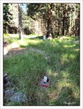
in Czech Geodetic Points Trigonometrický bod ležící na okraji masívu Kralického Snežníku na území Polské Republiky posted by:  vraatja vraatja location: Dolnośląskie, Poland date approved: 07/21/2011 last visited: never |
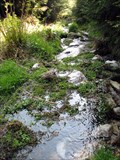 view gallery view galleryE1.9 km |  ORIGIN - Nysa Klodzka ORIGIN - Nysa Klodzka
in River Origins, Destinations and Confluences The origin of Nysa Klodzka. posted by:  Anneke Anneke location: Dolnośląskie, Poland date approved: 05/05/2009 last visited: 05/02/2009 |
 view gallery view gallery SW2.4 km SW2.4 km
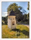
|  Wayside shride of Saint Onuphrius / Kapliczka sw.Onufrego - Pisary, Poland Wayside shride of Saint Onuphrius / Kapliczka sw.Onufrego - Pisary, Poland
in Wayside shrines Prismatic wayside shrine made of plastered bricks with a conical roof at the road in village Pisary near Miedzylesie at the borders with the Czech Republic posted by: vraatja location: Dolnośląskie, Poland date approved: 07/28/2019 last visited: never |
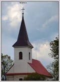
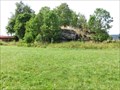
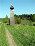 view gallery view galleryE2.4 km |  Bell tower at Freudeberg / Zvonicka na Freudebergu Bell tower at Freudeberg / Zvonicka na Freudebergu
in Bell Towers An interesting bell tower close to the tourist trail. posted by: Dadan location: Pardubický kraj, Czechia date approved: 05/05/2009 last visited: 08/22/2010 |
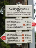
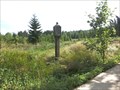
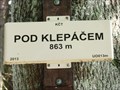 view gallery view galleryE2.7 km |  Elevation Sign - Pod Klepacem, Czech Republic.863m Elevation Sign - Pod Klepacem, Czech Republic.863m
in Elevation Signs Elevation Sign - Pod Klepacem posted by: ToRo61 location: Pardubický kraj, Czechia date approved: 12/12/2015 last visited: never |
 view gallery view gallery SE2.7 km SE2.7 km
| TB 2511-10 Vetronka, CZ in Czech Geodetic Points Trigonometrický bod na vrcholu Vetrného kopce v oblasti prírodního parku Kralický Snežník. posted by: vraatja location: Pardubický kraj, Czechia date approved: 08/22/2010 last visited: never |
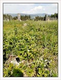
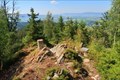
 view gallery view gallerySE2.9 km |  Palindrome - Horní Lipka (East Bohemia), Czech Republic Palindrome - Horní Lipka (East Bohemia), Czech Republic
in Coordinate Palindromes Coordinate palindrome on pastures located on the fringe of national nature preserve - Kralický Snežník mountain range. posted by: vraatja location: Pardubický kraj, Czechia date approved: 03/10/2011 last visited: never |
 view gallery view gallery NE2.9 km NE2.9 km
| TB 2511-4 Klepác in Czech Geodetic Points Trigonometrický bod na vrcholu Klepác posted by: alicek location: Pardubický kraj, Czechia date approved: 09/28/2008 last visited: 12/27/2015 |
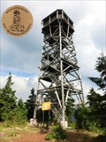 view gallery view galleryNE3.1 km |  No. 1879, Rozhledna Klepy, PL No. 1879, Rozhledna Klepy, PL
in Tourist Stamps Photos Klepy Look-Out posted by: ToRo61 location: Śląskie, Poland date approved: 12/12/2015 last visited: never |
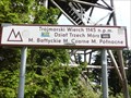 view gallery view galleryNE3.1 km |  Trójmorski Wierch - Klepy, Poland Trójmorski Wierch - Klepy, Poland
in Geographical Centers Trójmorski Wierch - Europe watershed (a roof of Europe). posted by: ToRo61 location: Śląskie, Poland date approved: 12/16/2015 last visited: never |
 view gallery view galleryNE3.1 km | Elevation Sign - Klepy, Poland.1143m in Elevation Signs Elevation Sign - Klepy, on the top of Klepy Mountain posted by: ToRo61 location: Śląskie, Poland date approved: 12/12/2015 last visited: never |
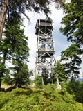 view gallery view galleryNE3.1 km |  Klepac Look-Out - Klepy, Poland Klepac Look-Out - Klepy, Poland
in Look-Out Towers Klepac Look-Out posted by: ToRo61 location: Małopolskie, Poland date approved: 12/12/2015 last visited: never |
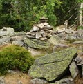 view gallery view galleryNE3.1 km |  Cairn - Klepy, Poland Cairn - Klepy, Poland
in Cairns Cairn on the top of roof of Europe... posted by: ToRo61 location: Śląskie, Poland date approved: 12/28/2015 last visited: never |
 view gallery view gallery S3.2 km S3.2 km
| TB 2512-3 kostel, Horní Lipka, CZ in Czech Geodetic Points Trigometrický bod tvorený stredem makovice veže rímskokatolického filiálního kostela sv. Anny v Horní Lipce. posted by: vraatja location: Pardubický kraj, Czechia date approved: 05/24/2010 last visited: never |
 view gallery view galleryS3.5 km | TB 2512-2 Roudný, CZ in Czech Geodetic Points Trigonometrický bod na vrcholu kopce Roudný ležícího západním smerem nad Horní Lipkou na Kralicku. posted by: vraatja location: Pardubický kraj, Czechia date approved: 05/28/2018 last visited: never |
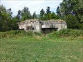
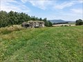
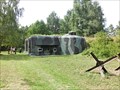 view gallery view gallerySE4.7 km |  Infantry blockhouse K-S 8 - Cerveny Potok, Czech Republic Infantry blockhouse K-S 8 - Cerveny Potok, Czech Republic
in Military Installations The infantry blockhouse K-S 8 (code name "U nádraží") is part of the extended system of fortifications built to defend the former Czechoslovakia during the second half of the 30s. posted by: ToRo61 location: Pardubický kraj, Czechia date approved: 12/18/2015 last visited: never |
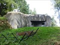
 view gallery view gallerySE4.8 km | Infantry blockhouse K-S 7 - Cerveny Potok, Czech Republic in Military Installations The infantry blockhouse K-S 7 (code name "U vesnice") is part of the extended system of fortifications built to defend the former Czechoslovakia during the second half of the 30s. posted by: ToRo61 location: Pardubický kraj, Czechia date approved: 12/18/2015 last visited: never |
 view gallery view gallerySE4.8 km | Wayside shrine - Cerveny Potok, Czech Republic in Wayside shrines Wayside shrine - Cerveny Potok posted by: ToRo61 location: Pardubický kraj, Czechia date approved: 12/18/2015 last visited: never |
 view gallery view galleryE5 km | ZGS 16_n KRAL in Czech Geodetic Points Bod základní geodynamické síte c. 16 KRAL (Králíky) posted by: rsc_cz location: Pardubický kraj, Czechia date approved: 02/12/2021 last visited: never |
 view gallery view gallerySE5 km | Infantry blockhouse K-S 6 - Cerveny Potok, Czech Republic in Military Installations The infantry blockhouse K-S 6 (code name "U kaplicky") is part of the extended system of fortifications built to defend the former Czechoslovakia during the second half of the 30s. posted by: ToRo61 location: Pardubický kraj, Czechia date approved: 12/18/2015 last visited: never |
 view gallery view galleryS5.1 km | Infantry blockhouse K-Bg-S 10 - Kraliky, Czech Republic in Military Installations The Infantry blockhouse K-Bg-S 10 (code name "U boží muky") is part of the Hurka Artillery Fort. posted by: ToRo61 location: Pardubický kraj, Czechia date approved: 12/18/2015 last visited: never |
 view gallery view gallerySE5.3 km | Infantry blockhouse K-S 5 - Cerveny Potok, Czech Republic in Military Installations The infantry blockhouse K-S 5 (code name "U potoka") is part of the extended system of fortifications built to defend the former Czechoslovakia during the second half of the 30s. posted by: ToRo61 location: Olomoucký kraj, Czechia date approved: 12/18/2015 last visited: never |
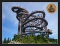 view gallery view galleryE5.3 km | No. 2255 - Stezka v oblacích - Dolní Morava, CZ in Tourist Stamps Photos The Sky Walk is a 55-m (180-ft)-high wooden walkway on top of a mountain at the top station of chair lift Snežník, at an altitude of 1116 meters above sea level./ Unikátní 55 metru vysoká rozhledna na úpatí hory Slamník v nadmorské výšce 1116 metru. posted by: vraatja location: Pardubický kraj, Czechia date approved: 07/12/2016 last visited: 09/22/2017 |
 view gallery view galleryS5.3 km |  Infantry blockhouse K-S 14 - Kraliky, Czech Republic Infantry blockhouse K-S 14 - Kraliky, Czech Republic
in Exact Replicas The model of the infantry blockhouse code name K-S 14 "Cihelna". posted by: ToRo61 location: Pardubický kraj, Czechia date approved: 11/30/2014 last visited: never |
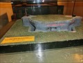
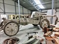 view gallery view galleryS5.3 km |  Howitzer vz. 18/47 - Kraliky, Czech Republic Howitzer vz. 18/47 - Kraliky, Czech Republic
in Static Artillery Displays The Czechoslovakian howitzer vz. 18/47 in Králíky Military Museum. posted by: ToRo61 location: Pardubický kraj, Czechia date approved: 11/30/2014 last visited: never |
|