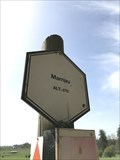
 view gallery view gallery E7.2 km E7.2 km
|   470 m - Marnau - Neufchâteau - Belgique 470 m - Marnau - Neufchâteau - Belgique
in Elevation Signs Signe d'altitude Marnau posted by:  franketmuriel franketmuriel location: Luxembourg, Belgium date approved: 04/23/2019 last visited: 03/13/2023 |
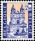 view gallery view gallery N12.2 km N12.2 km
|  Basilique Saint-Hubert - Saint-Hubert - Belgique Basilique Saint-Hubert - Saint-Hubert - Belgique
in Philatelic Photographs [FR] Timbre représentant la basilique Saint-Hubert, Église abbatiale de l'abbaye de Saint-Pierre en Ardenne (687-1797). [EN] Stamp picturing Saint-Hubert basilica, abbey church of Saint-Pierre abbey in Ardenne (687-1797). posted by: PaulLassiter location: Luxembourg, Belgium date approved: 12/31/2020 last visited: never |
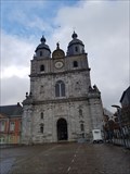 view gallery view galleryN12.2 km |  Basilique Saint-Hubert - Saint-Hubert - Belgique Basilique Saint-Hubert - Saint-Hubert - Belgique
in Wikipedia Entries [FR] Ancienne église de l'abbaye bénédictine fondée au VIIe siècle, reconstruite en 1526.[EN] Former church of the Benedictine abbey founded in the 7th century, rebuilt in 1526. posted by: PaulLassiter location: Luxembourg, Belgium date approved: 12/30/2020 last visited: never |
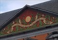
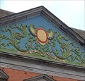 view gallery view galleryN12.2 km |  1729 - Abbaye de Saint-Hubert - Saint-Hubert, Belgique 1729 - Abbaye de Saint-Hubert - Saint-Hubert, Belgique
in Chronograms [FR] Chronogramme décoratif et coloré en haut du portail occidental du palais abbatial. [EN] Decorative and colourful chronogram at the top of the western portal of the abbot's palace. posted by: PaulLassiter location: Luxembourg, Belgium date approved: 01/05/2021 last visited: never |
 view gallery view galleryN12.2 km | 1729 - Abbaye de Saint-Hubert - Saint-Hubert, Belgique in Chronograms [FR] Chronogramme décoratif et coloré en haut du portail oriental du palais abbatial. [EN] Decorative and colourful chronogram at the top of the eastern portal of the abbot's palace. posted by: PaulLassiter location: Luxembourg, Belgium date approved: 01/05/2021 last visited: never |
 view gallery view galleryN12.2 km | Abbaye de Saint-Hubert - Saint-Hubert - Belgique in Wikipedia Entries [FR] Ancienne abbaye fondée vers 687 et devenue bénédictine en 817. [EN] Former abbey founded around 687 and became Benedictine in 817. posted by: PaulLassiter location: Luxembourg, Belgium date approved: 01/01/2021 last visited: never |
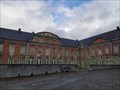 view gallery view galleryN12.2 km |  Abbaye de Saint-Hubert - Saint-Hubert - Belgique Abbaye de Saint-Hubert - Saint-Hubert - Belgique
in Abbeys, Convents and Monasteries [FR] Ancienne abbaye fondée vers 687 et devenue bénédictine en 817. [EN] Former abbey founded around 687 and became Benedictine in 817. posted by: PaulLassiter location: Luxembourg, Belgium date approved: 01/03/2021 last visited: never |
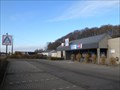 view gallery view galleryN12.2 km |  Aldi Store Saint-Hubert Belgium Aldi Store Saint-Hubert Belgium
in ALDI Stores Aldi Store Saint-Hubert Belgium posted by: Alfredo4 location: Luxembourg, Belgium date approved: 11/20/2011 last visited: never |
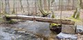 view gallery view galleryN17.7 km |  Pont Mauricy - Saint-Hubert, Luxembourg, Belgique Pont Mauricy - Saint-Hubert, Luxembourg, Belgique
in Hiking Path Footbridges [FR] Passerelle permettant d'enjamber le ruisseau de la Masblette [EN] Footbridge to cross the Masblette stream. posted by: Waldog location: Luxembourg, Belgium date approved: 04/05/2019 last visited: 11/29/2021 |
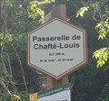 view gallery view gallery NW18 km NW18 km
|  49° 59' 30,96" 05° 08' 39,89" - Passerelle de Chafté-Louis - Libin - Belgique 49° 59' 30,96" 05° 08' 39,89" - Passerelle de Chafté-Louis - Libin - Belgique
in Permanent Geographic Coordinates [FR] Coordonnées géographiques DMS se trouvant sur le panneau de randonnée. [EN] Geographical coordinates DMS located on the hiking sign. posted by: PaulLassiter location: Luxembourg, Belgium date approved: 07/16/2019 last visited: never |
 view gallery view galleryNW18 km | Passerelle de Chafté-Louis - Libin - Belgique, 260 m. in Elevation Signs [FR] Signal d'altitude près de la passerelle sur une des promenades entre les rivières Lesse et Lomme. [EN] Altitude signal near the bridge on one of the parkways between the Lesse and Lomme rivers. posted by: PaulLassiter location: Luxembourg, Belgium date approved: 07/16/2019 last visited: never |
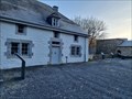 view gallery view galleryN18.5 km |  Ancien fourneau Saint-Michel et ses bâtiments - Saint-Hubert - Belgique Ancien fourneau Saint-Michel et ses bâtiments - Saint-Hubert - Belgique
in Belgium Monument Registers [FR] Ancien fourneau de l’abbaye de Saint-Hubert. [EN] Former furnace of the abbey of Saint-Hubert. posted by: PaulLassiter location: Luxembourg, Belgium date approved: 11/29/2021 last visited: never |
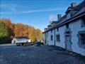 view gallery view galleryN18.5 km | Fourneau Saint-Michel - Saint-Hubert - Belgique in Wikipedia Entries [FR] Ancien fourneau de l’abbaye de Saint-Hubert. [EN] Former furnace of the abbey of Saint-Hubert. posted by: PaulLassiter location: Luxembourg, Belgium date approved: 11/29/2021 last visited: never |
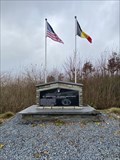 view gallery view gallery NE20.4 km NE20.4 km
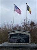
|  101st Airborne Division & 326th Airborne Medical Company Memorial - Saint-Ode 101st Airborne Division & 326th Airborne Medical Company Memorial - Saint-Ode
in World War II Memorials / Monuments Memorial for the 101st Airborne Division & 326th Airborne Medical Company posted by: Cecticide location: Luxembourg, Belgium date approved: 12/16/2021 last visited: never |
 view gallery view galleryNE20.4 km |  Barriere Hinck - WW2 - Saint-Ode, Belgium Barriere Hinck - WW2 - Saint-Ode, Belgium
in Field Hospitals Division Clearing Station of the 326th Airborne Medical Company with small hospital posted by: Cecticide location: Luxembourg, Belgium date approved: 12/13/2021 last visited: never |
 view gallery view gallery W22.7 km W22.7 km
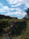
|  Château-Le-duc Château-Le-duc
in Castles Ruine du Château-le-Duc posted by: habot location: Belgium date approved: 08/16/2005 last visited: 07/25/2007 |
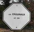 view gallery view galleryNW22.7 km | Les Erguinaux. Wellin, Belgique. 260 m. in Elevation Signs Signe d'altitude Les Erguinaux posted by: franketmuriel location: Luxembourg, Belgium date approved: 04/01/2020 last visited: never |
 view gallery view galleryNW23.2 km | Point de vue du Belvédère. Wellin, Belgique. 335 m. in Elevation Signs Signe d'altitude Point de vue du Belvédère. posted by: franketmuriel location: Luxembourg, Belgium date approved: 04/01/2020 last visited: never |
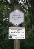 view gallery view galleryNW23.7 km | Chateau de Resteigne - Tellin - Belgique. 180m in Elevation Signs Signe d'altitude du lieu Château de Resteigne posted by: franketmuriel location: Luxembourg, Belgium date approved: 10/22/2017 last visited: 03/17/2019 |
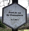 view gallery view galleryNW23.8 km | Point de vue de Chassepierre. Wellin, Belgique. 360 m. in Elevation Signs Signe d'altitude du Point de vue de Chassepierre. posted by: franketmuriel location: Luxembourg, Belgium date approved: 04/01/2020 last visited: never |
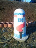 view gallery view galleryE24 km | Voie de la Liberté - N4 Hollange #2 in World War II Memorials / Monuments Liberty Road (French La voie de la Liberté) is the commemorative way marking the route of the Allied forces from D-Day in June 1944 posted by: naj16 location: Luxembourg, Belgium date approved: 12/04/2017 last visited: never |
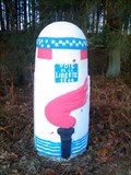 view gallery view galleryE24 km | Voie de la Liberté - N4 Hollange #3 in World War II Memorials / Monuments Liberty Road (French La voie de la Liberté) is the commemorative way marking the route of the Allied forces from D-Day in June 1944. posted by: naj16 location: Luxembourg, Belgium date approved: 12/04/2017 last visited: never |
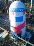 view gallery view galleryE24.1 km | Voie de la Liberté - N4 Hollange #1 in World War II Memorials / Monuments Liberty Road (French La voie de la Liberté) is the commemorative way marking the route of the Allied forces from D-Day in June 1944. posted by: naj16 location: Luxembourg, Belgium date approved: 12/04/2017 last visited: never |
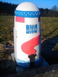 view gallery view galleryE24.1 km | Voie de la Liberté - N4 Sainlez #1 in World War II Memorials / Monuments Liberty Road (French La voie de la Liberté) is the commemorative way marking the route of the Allied forces from D-Day in June 1944. posted by: naj16 location: Luxembourg, Belgium date approved: 12/04/2017 last visited: never |
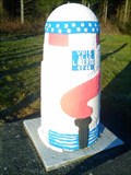 view gallery view galleryE24.3 km | Voie de la Liberté - N4 Sainlez #2 in World War II Memorials / Monuments Liberty Road (French La voie de la Liberté) is the commemorative way marking the route of the Allied forces from D-Day in June 1944. posted by: naj16 location: Luxembourg, Belgium date approved: 11/28/2017 last visited: never |
|