 view gallery view gallery N11.3 km N11.3 km
|   Lasca Creek Trailhead - Harrop, BC Lasca Creek Trailhead - Harrop, BC
in Mountain Bike Trailheads This wilderness trail is most easily reached from Harrop, on the south side of the West Arm. Get to Harrop by taking the ferry at Harrop Ferry Road south from Highway 3A, 7 km. west of the Balfour Ferry. posted by:  T0SHEA T0SHEA location: British Columbia, Canada date approved: 01/20/2014 last visited: 04/16/2014 |
 view gallery view galleryN11.3 km |  West Arm Provincial Park - Harrop, BC West Arm Provincial Park - Harrop, BC
in Campgrounds This wilderness park can be reached from Harrop, on the south side of the West Arm of Kootenay Lake. Get to Harrop by taking the ferry at Harrop Ferry Road, south from Highway 3A, 7 km. west of the Balfour Ferry. posted by: T0SHEA location: British Columbia, Canada date approved: 12/22/2014 last visited: never |
 view gallery view galleryN11.3 km | West Arm Provincial Park - Harrop, BC in Free Campsites This wilderness park can be reached from Harrop, on the south side of the West Arm of Kootenay Lake. Get to Harrop by taking the ferry at Harrop Ferry Road, south from Highway 3A, 7 km. west of the Balfour Ferry. posted by: T0SHEA location: British Columbia, Canada date approved: 12/21/2014 last visited: never |
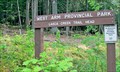 view gallery view galleryN11.3 km |  West Arm Provincial Park - Harrop, BC West Arm Provincial Park - Harrop, BC
in State/Provincial Parks This wilderness park can be reached from Harrop, on the south side of the West Arm. Get to Harrop by taking the ferry at Harrop Ferry Road, south from Highway 3A, 7 km. west of the Balfour Ferry. posted by: T0SHEA location: British Columbia, Canada date approved: 01/20/2014 last visited: 04/16/2014 |
 view gallery view galleryN11.3 km |  Lasca Creek Trailhead - Harrop, BC Lasca Creek Trailhead - Harrop, BC
in Hiking and walking trailheads This wilderness trail is most easily reached from Harrop, on the south side of the West Arm. Get to Harrop by taking the ferry at Harrop Ferry Road south from Highway 3A, 7 km. west of the Balfour Ferry. posted by: T0SHEA location: British Columbia, Canada date approved: 01/20/2014 last visited: 04/16/2014 |
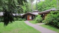
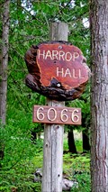 view gallery view galleryN11.6 km |  Harrop Hall - Harrop, BC Harrop Hall - Harrop, BC
in Municipal Community Centers The communities of Harrop and Procter each have a community hall - this is the Harrop Community Hall. posted by: T0SHEA location: British Columbia, Canada date approved: 02/05/2014 last visited: 05/16/2014 |
 view gallery view galleryN11.7 km |  Harrop Dedicated Welcome Sign - Harrop, BC Harrop Dedicated Welcome Sign - Harrop, BC
in Citizen Memorials This welcome sign is one of the village of Harrop's gifts to itself on its 100th birthday. It was dedicated in memory of Ernest and Bertha Harrop. posted by: T0SHEA location: British Columbia, Canada date approved: 01/26/2014 last visited: 04/28/2014 |
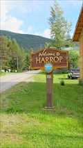 view gallery view galleryN11.7 km |  Welcome Sign - Harrop, BC Welcome Sign - Harrop, BC
in Community Commemoration This welcome sign is one of the village of Harrop's gifts to itself on its 100th birthday. posted by: T0SHEA location: British Columbia, Canada date approved: 01/27/2014 last visited: 04/27/2014 |
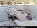 view gallery view galleryN11.9 km |  Harrop South Ferry Landing Webcam - Harrop, BC Harrop South Ferry Landing Webcam - Harrop, BC
in Web Cameras This is one of three BC Highways webcams at the north and south ferry landings for the Harrop Ferry. posted by: T0SHEA location: British Columbia, Canada date approved: 02/08/2016 last visited: never |
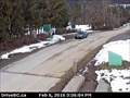
 view gallery view galleryN12.2 km | Harrop South Zoom Ferry Landing Webcam - Harrop, BC in Web Cameras This is one of three BC Highways webcams at the north and south ferry landings for the Harrop Ferry and one of a pair on the south side of the Kootenay River. posted by: T0SHEA location: British Columbia, Canada date approved: 02/08/2016 last visited: never |
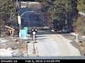
 view gallery view galleryN12.2 km | Harrop North Ferry Landing Webcam - Harrop, BC in Web Cameras This is one of three BC Highways webcams at the north and south ferry landings for the Harrop Ferry. posted by: T0SHEA location: British Columbia, Canada date approved: 02/08/2016 last visited: never |
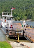
 view gallery view galleryN12.2 km |  North Side Landing - Harrop Procter Ferry - Harrop, BC North Side Landing - Harrop Procter Ferry - Harrop, BC
in Ferries and Ferry Landings This is the Harrop Procter Ferry landing on the north side of the Kootenay River. The ferry serves the communities of Harrop and Procter on the south side of the river, neither of which can be accessed by another road route. posted by: T0SHEA location: British Columbia, Canada date approved: 01/27/2014 last visited: 04/25/2014 |
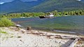
 view gallery view galleryN12.2 km | South Side Landing - Harrop Procter Ferry - Harrop, BC in Ferries and Ferry Landings This is the Harrop Procter Ferry landing on the south side of the Kootenay River. The ferry serves the communities of Harrop and Procter on the south side of the river, neither of which can be accessed by another road route. posted by: T0SHEA location: British Columbia, Canada date approved: 01/27/2014 last visited: 04/27/2014 |
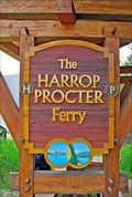
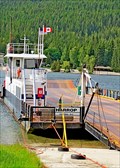
 view gallery view galleryN12.2 km |  Harrop Ferry - Harrop, BC Harrop Ferry - Harrop, BC
in Satellite Imagery Oddities This is the Harrop Procter Ferry which serves the communities of Harrop and Procter on the south side of the Kootenay River, neither of which can be accessed by another road route. posted by: T0SHEA location: British Columbia, Canada date approved: 02/20/2016 last visited: never |
 view gallery view galleryN12.2 km |  Harrop ferry moved to dry dock Harrop ferry moved to dry dock
in News Article Locations The Harrop Procter Ferry serves the communities of Harrop and Procter on the south side of the Kootenay River, AKA the West Arm of Kootenay Lake, neither of which can be accessed by another road route. posted by: T0SHEA location: British Columbia, Canada date approved: 04/04/2017 last visited: never |
 view gallery view gallery NW12.6 km NW12.6 km
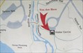
|  Kokanee Creek Park Visitor Centre UR Here Map Number 2 - Balfour, BC Kokanee Creek Park Visitor Centre UR Here Map Number 2 - Balfour, BC
in 'You Are Here' Maps This is one of two UR Here Maps outside the visitor centre in Kokanee Creek Provincial Park, which is about 11 km. west of Balfour, on Kootenay Lake. posted by: T0SHEA location: British Columbia, Canada date approved: 07/30/2013 last visited: 03/19/2014 |
 view gallery view galleryNW12.6 km | Kokanee Creek Park Visitor Centre UR Here Map Number 1 - Balfour, BC in 'You Are Here' Maps This is one of two UR Here Maps outside the visitor centre in Kokanee Creek Provincial Park, which is about 11 km. west of Balfour, on Kootenay Lake. posted by: T0SHEA location: British Columbia, Canada date approved: 07/30/2013 last visited: 03/19/2014 |
 view gallery view galleryN12.6 km | Grades 6 and 7 returning to Redfish school in News Article Locations About five kilometres west of the town of Balfour, On Kootenay Lake, is the Redfish Elementary, complete with School Bell Tower posted by: T0SHEA location: British Columbia, Canada date approved: 07/07/2018 last visited: never |
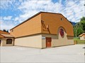
 view gallery view galleryN12.6 km |  1987 - Redfish Elementary School - Balfour, BC 1987 - Redfish Elementary School - Balfour, BC
in Dated Buildings and Cornerstones About five kilometres west of the town of Balfour, On Kootenay Lake, is the Redfish Elementary, complete with School Bell Tower posted by: T0SHEA location: British Columbia, Canada date approved: 07/07/2018 last visited: never |
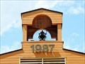 view gallery view galleryN12.6 km |  Redfish Elementary School Bell Tower - Balfour, BC Redfish Elementary School Bell Tower - Balfour, BC
in Bell Towers About five kilometres west of the town of Balfour, On Kootenay Lake, is the Redfish Elementary, complete with School Bell Tower posted by: T0SHEA location: British Columbia, Canada date approved: 07/07/2018 last visited: never |
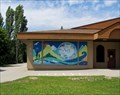 view gallery view galleryN12.6 km |  Kokanee Life Cycle - Nelson, British Columbia Kokanee Life Cycle - Nelson, British Columbia
in Murals Kokanee Life Cycle is on the Redfish Elementary School located at 265 Bryan Road just off Hwy. 3A. posted by: T0SHEA location: British Columbia, Canada date approved: 07/12/2018 last visited: never |
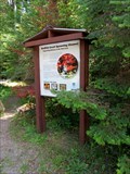 view gallery view galleryN12.6 km |  Redfish Creek Spawning Channel - Nelson, British Columbia Redfish Creek Spawning Channel - Nelson, British Columbia
in Flora and Fauna Information Signs Redfish Creek Spawning Channel informational sign is located off Hwy. 3A across from Redfish Elementary School on Bryan Road posted by: T0SHEA location: British Columbia, Canada date approved: 07/09/2018 last visited: never |
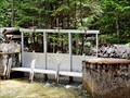 view gallery view galleryN12.6 km |  Redfish Creek Sluice Gates - Balfour, BC Redfish Creek Sluice Gates - Balfour, BC
in Historic Hand Operated Sluice Gates Stopped in at Redfish Creek yesterday and got a pleasant surprise. posted by: T0SHEA location: British Columbia, Canada date approved: 07/07/2018 last visited: never |
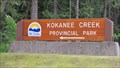 view gallery view galleryNW12.7 km | Kokanee Creek Provincial Park - Balfour, BC in Campgrounds This 260 hectare Provincial Park Straddles Highway 3A 19 km. east of Nelson and 12 km. west of Balfour. posted by: T0SHEA location: British Columbia, Canada date approved: 12/22/2014 last visited: never |
 view gallery view galleryNW12.7 km |  Kokanee Creek Provincial Park Visitor Centre - Balfour, BC Kokanee Creek Provincial Park Visitor Centre - Balfour, BC
in Tourist Information Centers - Visitor Centers This 260 hectare Provincial Park Straddles Highway 3A 19 km. east of Nelson and 12 km. west of Balfour. The visitor centre is within the administration centre west of the Sandspit Campground on the south side of the highway. posted by: T0SHEA location: British Columbia, Canada date approved: 01/22/2014 last visited: 04/16/2014 |
|