 view gallery view gallery W20.4 km W20.4 km
|   CEYLON GAP SWIM - Ceylon, Saskatchewan CEYLON GAP SWIM - Ceylon, Saskatchewan
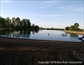
in Public Swimming Pools Man-made sandy pool in Ceylon Regional Park posted by:  Bon Echo Bon Echo location: Saskatchewan, Canada date approved: 12/15/2018 last visited: never |
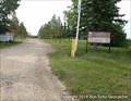 view gallery view galleryW20.4 km |  Ceylon Regional Park - Ceylon, Saskatchewan Ceylon Regional Park - Ceylon, Saskatchewan
in Municipal Parks and Plazas Regional Park near Ceylon SK posted by: Bon Echo location: Saskatchewan, Canada date approved: 11/19/2018 last visited: never |
 view gallery view gallery NW37.5 km NW37.5 km
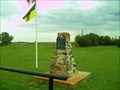
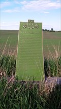
|  The Village of Amulet The Village of Amulet
in Saskatchewan Historical Markers Historical account of Amulet. posted by: Altima Voyageur location: Saskatchewan, Canada date approved: 09/29/2010 last visited: never |
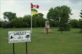 view gallery view galleryNW37.5 km |  Amulet, Sask. Amulet, Sask.
in Ghost Towns Nothing left but a few trees and memories. posted by: kjohn73 location: Saskatchewan, Canada date approved: 07/15/2009 last visited: never |
 view gallery view gallery NE38.6 km NE38.6 km
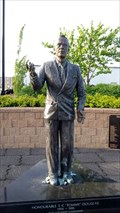
| Tommy Douglas in Saskatchewan Historical Markers North side of the river, West of 3rd Street South, South of Industrial Lane, or South Side of Kal Tire store. posted by: Altima Voyageur location: Saskatchewan, Canada date approved: 12/23/2016 last visited: never |
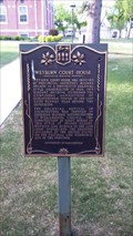 view gallery view galleryNE39.4 km | Weyburn Court House in Saskatchewan Historical Markers Located along Prairie Avenue, between Second Street and Fourth Street. posted by: Altima Voyageur location: Saskatchewan, Canada date approved: 12/23/2016 last visited: never |
 view gallery view galleryW46.3 km | Ogema Firewall 1915 in Saskatchewan Historical Markers Located on Main Street. posted by: Altima Voyageur location: Saskatchewan, Canada date approved: 05/02/2017 last visited: never |
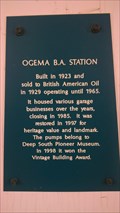 view gallery view galleryW46.3 km | Ogema B.A. Station in Saskatchewan Historical Markers An old British American gas station. posted by: Altima Voyageur location: Saskatchewan, Canada date approved: 05/02/2017 last visited: never |
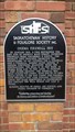
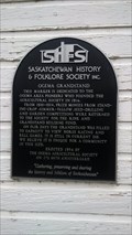 view gallery view galleryW46.3 km | Ogema Grandstand in Saskatchewan Historical Markers A marker describing the grandstand. posted by: Altima Voyageur location: Saskatchewan, Canada date approved: 05/02/2017 last visited: never |
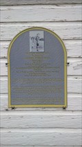 view gallery view galleryW46.3 km | Arleene Johnson Noga in Saskatchewan Historical Markers Arleene Johnson Noga earned a spot in the All-American Girls Professional Baseball League. A document movie was watch by Penny Marshall became inspirational movie called "A League of Their Own" This plaque is located on the Grandstand. posted by: Altima Voyageur location: Saskatchewan, Canada date approved: 05/02/2017 last visited: never |
 view gallery view gallery SE48 km SE48 km
| NWMP Trek West in Saskatchewan Historical Markers East side of HWY posted by: Altima Voyageur location: Saskatchewan, Canada date approved: 12/23/2016 last visited: never |
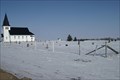
 view gallery view gallerySE58.9 km |  Lac Qui Parle Lutheran Cemetery - Torquay District, Sask. - Canada Lac Qui Parle Lutheran Cemetery - Torquay District, Sask. - Canada
in Churchyard Cemeteries A rather large cemetery on a quiet rural Saskatchewan road. posted by: kjohn73 location: Saskatchewan, Canada date approved: 02/25/2010 last visited: 08/26/2017 |
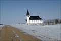
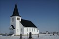 view gallery view gallerySE58.9 km |  Lac Qui Parle Lutheran Church - Torquay District, Sask. - Canada Lac Qui Parle Lutheran Church - Torquay District, Sask. - Canada
in Lutheran Churches Nicely maintained old church on a quiet road. posted by: kjohn73 location: Saskatchewan, Canada date approved: 02/22/2010 last visited: 08/26/2017 |
 view gallery view gallerySE58.9 km |  Lac Qui Parle Lutheran Church Outhouse - Torquay District, Sask. - Canada Lac Qui Parle Lutheran Church Outhouse - Torquay District, Sask. - Canada
in Outhouses A typical two-holer in a churchyard. posted by: kjohn73 location: Saskatchewan, Canada date approved: 02/23/2010 last visited: never |
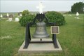 view gallery view galleryNE59.2 km |  Cedoux Parish Bell - Cedoux District, SK Cedoux Parish Bell - Cedoux District, SK
in Bells Beautiful old bell in a cemetery. posted by: kjohn73 location: Saskatchewan, Canada date approved: 07/14/2009 last visited: never |
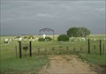 view gallery view galleryNE59.2 km |  Cedoux Community Cemetery - Cedoux District, SK Cedoux Community Cemetery - Cedoux District, SK
in Worldwide Cemeteries Rural cemetery contains many pioneer graves. Approx. 190 graves. posted by: kjohn73 location: Saskatchewan, Canada date approved: 07/16/2009 last visited: never |
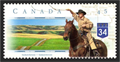 view gallery view galleryW63.4 km |  Big Muddy Badlands, SK, Canada Big Muddy Badlands, SK, Canada
in Philatelic Photographs This stamp shows the view from southbound highway 34 just before it descends into the Big Muddy Valley in southern Saskatchewan. posted by:  hykesj hykesj location: Saskatchewan, Canada date approved: 04/03/2017 last visited: never |
 view gallery view gallery SW64.4 km SW64.4 km
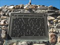
| Big Muddy Detachment RNWMP/ Last Mounted Horse Patrol in Saskatchewan Historical Markers Unfortunately this is located on private land that has a locked gate. I I was able to see this through a tour that is provided by Big Muddy Tours out of Coronach, Saskatchewan. posted by: Altima Voyageur location: Saskatchewan, Canada date approved: 09/30/2013 last visited: never |
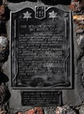 view gallery view gallerySW71.6 km | The Willow Bunch - Big Muddy Trail in Saskatchewan Historical Markers This cain was erected by the South Country Buckaroos, 4H Horse Club in co-operation with the Saskatchewan Department of Natural Resources in the year 1967. posted by: Altima Voyageur location: Saskatchewan, Canada date approved: 09/22/2013 last visited: 07/21/2017 |
 view gallery view gallery S72.6 km S72.6 km
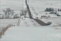
|  Comertown Turn-Off East - Plentywood, MT Comertown Turn-Off East - Plentywood, MT
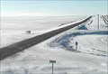
in Web Cameras This is one of 73 (as of January 2017) Road Weather Information System cameras operated by the Montana Department of Transportation to aid motorists as they make their way across BIG SKY Country. posted by: T0SHEA location: Montana date approved: 01/12/2017 last visited: never |
 view gallery view galleryS72.6 km | Comertown Turn-Off West - Plentywood, MT in Web Cameras This is one of 73 (as of January 2017) Road Weather Information System cameras operated by the Montana Department of Transportation to aid motorists as they make their way across BIG SKY Country. posted by: T0SHEA location: Montana date approved: 01/12/2017 last visited: never |
 view gallery view gallerySW75.2 km | Big Beaver, Schools that are History! in Saskatchewan Historical Markers This plaque is located on the Dan Galbraith cairn. It mentions all the country schools that were located around the community of Big Beaver. posted by: Altima Voyageur location: Saskatchewan, Canada date approved: 09/29/2013 last visited: never |
 view gallery view gallerySW75.2 km | Dan Galbraith in Saskatchewan Historical Markers This huge cairn was located by an building that was almost missed when I drove by! This is located in the small community of Big Beaver, Saskatchewan. posted by: Altima Voyageur location: Saskatchewan, Canada date approved: 09/29/2013 last visited: never |
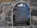
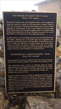 view gallery view galleryNW77.1 km | Sisters of Charity of St. Louis, Wilcox: 1920-present in Saskatchewan Historical Markers Located in the Town of Wilcox. posted by: Altima Voyageur location: Saskatchewan, Canada date approved: 05/02/2017 last visited: never |
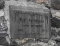
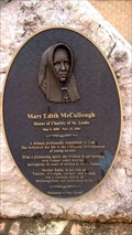 view gallery view galleryNW77.1 km | Mary Edith McCullough in Saskatchewan Historical Markers Located in town of Wilcox, this monument on the Campus of Notre Dame of Canada. posted by: Altima Voyageur location: Saskatchewan, Canada date approved: 05/02/2017 last visited: never |
|