 view gallery view gallery SE10.3 km SE10.3 km
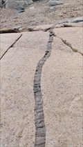
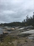
|   Diabase Rock Formation -Pointe des Monts Diabase Rock Formation -Pointe des Monts
in Places of Geologic Significance These dikes are always impressive. posted by:  davidb1957 davidb1957 location: Québec, Canada date approved: 08/26/2021 last visited: 12/13/2022 |
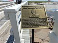 view gallery view gallerySE10.3 km |  Pont Lorrain Boucher-Pointes-des-Monts, Baie Trinité, Québec-Canada Pont Lorrain Boucher-Pointes-des-Monts, Baie Trinité, Québec-Canada
in People-Named Places Un pont pédestre au nom d'un citoyen dévoué;
A bridge named on behalf of a devoted citizen posted by: gemeloj location: Québec, Canada date approved: 10/16/2017 last visited: 08/17/2019 |
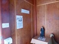 view gallery view gallerySE10.3 km |  Livre d'or de la Chapelle- Pointe-des-Monts, Baie Trinité, Qc-Canada Livre d'or de la Chapelle- Pointe-des-Monts, Baie Trinité, Qc-Canada
in Guest Books A logbook will be waiting in the chapel;Un livre de bord vous attend dans la chapelle posted by: gemeloj location: Québec, Canada date approved: 08/17/2015 last visited: 08/08/2018 |
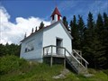 view gallery view gallerySE10.3 km |  Chapelle de Pointe-des-Monts- Baie Trinitée, Manicouagan, Québec-Canada Chapelle de Pointe-des-Monts- Baie Trinitée, Manicouagan, Québec-Canada
in Waychapels A small chapel, the door opening of the lighthouse and the river; Une petite chapelle , la porte s'ouvrant sur le phare et le fleuve posted by: gemeloj location: Québec, Canada date approved: 08/17/2015 last visited: 07/04/2016 |
 view gallery view gallerySE10.5 km |  Le pigeonnier-Pointe-des-Monts, Baie Trinité, Qc-Canada Le pigeonnier-Pointe-des-Monts, Baie Trinité, Qc-Canada
in Aviaries Ancien entrepôt du phare de la Pointe, en 1959, le bâtiment est devenu un pigeonnier. posted by: gemeloj location: Québec, Canada date approved: 08/17/2015 last visited: 08/08/2018 |
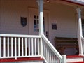 view gallery view gallerySE10.5 km |  B&B -phare du gardien-Pointe-des-Monts,Québec-Canada B&B -phare du gardien-Pointe-des-Monts,Québec-Canada
in Lighthouse Bed and Breakfasts Give yourself at least one night in one of the four rooms of the ancient gatehouse. posted by: gemeloj location: Québec, Canada date approved: 08/13/2015 last visited: 07/04/2016 |
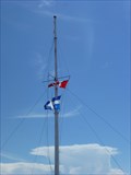 view gallery view gallerySE10.5 km |  Flag pole-Pointe-des-Monts- Québec,Canada Flag pole-Pointe-des-Monts- Québec,Canada
in Nautical Flag Poles A mat on the huge rocks of the Pointe
Un mat sur les énormes roches de la Pointe posted by: gemeloj location: Québec, Canada date approved: 08/17/2015 last visited: 08/08/2018 |
 view gallery view gallerySE10.5 km |  49° 19'20¨N 67° 22'30¨W-Pointe-des-Monts,Québec-Canada 49° 19'20¨N 67° 22'30¨W-Pointe-des-Monts,Québec-Canada
in Permanent Geographic Coordinates coordinates of Landmark of the North Coast;coordonées sur un site touristique de la côte nord posted by: gemeloj location: Québec, Canada date approved: 08/19/2015 last visited: 08/08/2018 |
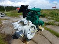 view gallery view gallerySE10.5 km |  Corne de brume de Pointe-des-Monts, Baie Trinitée, Québec-Canada Corne de brume de Pointe-des-Monts, Baie Trinitée, Québec-Canada
in Preserved Machines on Public Display Overall, a diesel engine and a compressor which was used to pump air was used to operate the foghorn
Ensemble, un moteur diesel et un compresseur qui a été utilisé pour pomper l'air qui était utilisée pour faire fonctionner la corne de brume posted by: gemeloj location: Québec, Canada date approved: 08/13/2015 last visited: 08/08/2018 |
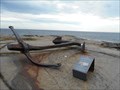 view gallery view gallerySE10.5 km |  L'Ancre du Cimba - Anchor salvaged from the Cimba L'Ancre du Cimba - Anchor salvaged from the Cimba
in Anchors Une vielle ancre à Pointe-des-Monts, Québec, Canada.
An anchor on public display at Pointe-des-Monts,Québec,Canada. posted by: VE2YWS location: Québec, Canada date approved: 09/13/2014 last visited: 08/08/2018 |
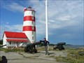 view gallery view gallerySE10.5 km | ") Phare de Pointe-des-Monts - Baie Trinité - Manicouagan Phare de Pointe-des-Monts - Baie Trinité - Manicouagan
in Histoire du Quebec (Quebec Historical Markers) Très beau phare à Baie Trinité où l'on peut déguster de très bon repas posted by: volatile location: Québec, Canada date approved: 09/09/2011 last visited: 07/04/2016 |
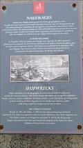 view gallery view gallerySE10.5 km |  Le Cimba Le Cimba
in Shipwrecks Un point de vue où l'épave de Cimba s'est produite.
A viewing point where the wreck of Cimba occured. posted by: VE2YWS location: Québec, Canada date approved: 09/14/2014 last visited: 08/08/2018 |
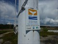
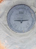
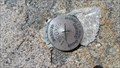 view gallery view gallerySE10.5 km |  Benchmarks à la Pointe des Monts 92k0541 Benchmarks à la Pointe des Monts 92k0541
in Canadian Benchmarks Benchmarks Énergies et Ressources Québec posted by: SCALAIRE location: Québec, Canada date approved: 08/26/2014 last visited: 08/08/2018 |
 view gallery view gallerySE10.5 km | DIABASE ROCK FORMATION in Places of Geologic Significance DIABASE, also called Dolerite, is fine to medium grained, dark gray to black intrusive igneous rock. posted by: davidb1957 location: Québec, Canada date approved: 09/14/2014 last visited: 08/08/2018 |
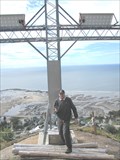
 view gallery view gallery SW10.9 km SW10.9 km
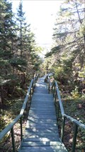
|  403 steps - Godbout, Quebec 403 steps - Godbout, Quebec
in Outdoor Stairways 403 steps to the cross and a great view of the bay. posted by: davidb1957 location: Québec, Canada date approved: 12/08/2015 last visited: 09/26/2018 |
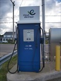 view gallery view gallerySW11.9 km |  Borne de recharge, Godbout, Qc. Canada Borne de recharge, Godbout, Qc. Canada
in Electric Car Charging Stations Borne de recharge à Godbout pres du quai An electric car charging station located in Godbout, Quebec. posted by: davidb1957 location: Québec, Canada date approved: 08/20/2020 last visited: 10/09/2021 |
 view gallery view gallery E12.1 km E12.1 km
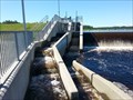
|  Passe à Saumon - Baie Trinité - Salmon Ladder Passe à Saumon - Baie Trinité - Salmon Ladder
in Fish Ladders Une passe à saumon situé sur la Rivière Trinité
A salmon ladder situated on the Trinité (Trinity) River. posted by: VE2YWS location: Québec, Canada date approved: 08/12/2015 last visited: 08/17/2019 |
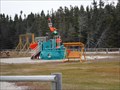 view gallery view gallerySW13.2 km |  Godbout Playground Godbout Playground
in Public Playgrounds Multi functional playground for the young and old. posted by: davidb1957 location: Québec, Canada date approved: 12/12/2015 last visited: 10/02/2016 |
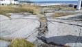
 view gallery view gallerySW13.7 km | Godbout's Alluvial Fan in Places of Geologic Significance An alluvial fan is a triangle-shaped deposit of gravel, sand, and even smaller pieces of sediment, such as silt. This sediment is called alluvium. posted by: davidb1957 location: Québec, Canada date approved: 09/14/2014 last visited: 10/13/2014 |
 view gallery view gallery NE21.1 km NE21.1 km
| HYDROGRAPHIC SERVICE CANADA #86L9249 at Pointe des Jourdains in Canadian Benchmarks HYDROGRAPHIC SERVICE CANADA #86L9249 posted by: davidb1957 location: Québec, Canada date approved: 07/27/2020 last visited: 09/24/2020 |
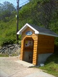
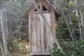 view gallery view gallerySW28.5 km |  La bécosse de l'Anse à la Croix - Franquelin, Qc La bécosse de l'Anse à la Croix - Franquelin, Qc
in Outhouses Une bécosse situé dans le bois près de l'Anse à la Croix à Franquelin. posted by: LadyKarine location: Québec, Canada date approved: 10/18/2019 last visited: 10/19/2019 |
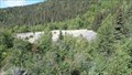
 view gallery view gallerySW28.5 km | Bloc Erratique Chemin de la Pointe à La Croix in Places of Geologic Significance Un bloc erratique est, en géologie et en géomorphologie, un fragment de roche d'origine morainique qui a été déplacé par un glacier parfois sur de grandes distances. Lors de la fonte du glacier, le bloc erratique est abandonné sur place posted by: Casper&Aero location: Québec, Canada date approved: 09/26/2019 last visited: 07/02/2022 |
 view gallery view gallerySW28.5 km |  Dyke Chemin de la Pointe à La Croix Dyke Chemin de la Pointe à La Croix
in Scenic Overlooks Un dyke ou dike est un filon de roches qui s'est injecté dans une fracturation de l'encaissant. De ce fait, un dyke recoupe les autres roches qu'il traverse (à la différence d'un sill). posted by: Casper&Aero location: Québec, Canada date approved: 09/25/2019 last visited: 07/02/2022 |
 view gallery view gallery W32.7 km W32.7 km
|  La Croix de Franquelin, Qc. Canada La Croix de Franquelin, Qc. Canada
in Christian Crosses Une Croix sur la montagne à plus de 200 metres d'altitude.
A cross on the mountain overlooking the town of Franquelin on the St.Lawrence River. posted by: VE2YWS location: Québec, Canada date approved: 09/12/2013 last visited: 10/31/2014 |
 view gallery view galleryW33.3 km |  La source a Wallace La source a Wallace
in Natural Springs Une source naturelle a Franquelin sur la rue des Cèdres (rt138) posted by: SCALAIRE location: Québec, Canada date approved: 08/17/2014 last visited: 10/14/2017 |
|